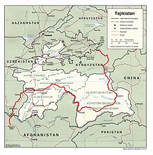
Tajikistan, officially the Republic of Tajikistan, is a landlocked country in Central Asia. Dushanbe is the capital and most populous city. Tajikistan is bordered by Afghanistan to the south, Uzbekistan to the west, Kyrgyzstan to the north, and China to the east. It is separated from Pakistan by Afghanistan's Wakhan Corridor. It has a population of approximately 10.6 million people.

Transport in Afghanistan is done mostly by road, rail and air. Much of the nation's road network was built in the mid-20th century but left to ruin during the last two decades of that century due to war and political turmoil. Officials of the current Islamic Emirate have continued to improve the national highways, roads, and bridges. In 2008, there were about 700,000 vehicles registered in Kabul. At least 1,314 traffic collisions were reported in 2022.

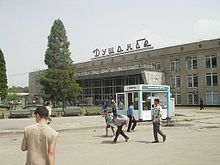
Dushanbe is the capital and largest city of Tajikistan. As of March 2024, Dushanbe had a population of 1,564,700, with this population being largely Tajik. Until 1929, the city was known in Russian as Dyushambe, and from 1929 to 1961 as Stalinabad, after Joseph Stalin. Dushanbe is located in the Gissar Valley, bounded by the Gissar Range in the north and east and the Babatag, Aktau, Rangontau and Karatau mountains in the south, and has an elevation of 750–930 m. The city is divided into four districts: Ismail Samani, Avicenna, Ferdowsi, and Shah Mansur.

The Tajik Soviet Socialist Republic, also commonly known as Soviet Tajikistan, the Tajik SSR, TaSSR, or simply Tajikistan, was one of the constituent republics of the Soviet Union which existed from 1929 to 1991 in Central Asia.

Khujand, sometimes spelled Khodjent and formerly known as Leninabad from 1936 to 1991, is the second-largest city of Tajikistan and the capital of Tajikistan's northernmost Sughd province.

Asian Highway 7 (AH7) is a route in the Asian Highway Network. It runs from Yekaterinburg, Russia to Karachi, Pakistan. All together, it is 5,868 km (3,646 mi) long. It passes from Russia, Kazakhstan, Kyrgyzstan, Uzbekistan, Tajikistan, Afghanistan and Pakistan.
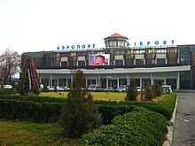
Tajik Air is a flag carrier airline of Tajikistan. It has its head office at Dushanbe International Airport in Dushanbe. The airline's main hub is Dushanbe International Airport.
Terrorism in Tajikistan stems largely from the forces of the political opposition who opposed the comprehensive peace agreement that ended the civil war in 1997. President Emomali Rahmonov and UTO leader Said Abdullah Nuri signed the agreement on 27 June, believing it would bring an end to hostilities. However, dissident Islamist militants led by Tohir Yo‘ldosh and Juma Namangani formed the Islamic Movement of Uzbekistan in 1998, allying with Al-Qaeda and vowing to unite Central Asia as an Islamic state. The latest terror attacks took place in the Qabodiyon District on November 6, 2019, when a policeman and a border guard were killed by several Islamic State militants. 15 terrorists were also killed.

Iran–Tajikistan relations refer to the bilateral relations between Iran and Tajikistan. Since the collapse of the Soviet Union, the two countries have naturally enjoyed a close and strong relationship with the two often being described as "one spirit in two bodies" by the ex-president of Iran Mahmoud Ahmadinejad due to both being Persian-speaking and Iranic countries.

The Anzob Tunnel, Istiqlol Tunnel, or Ushtur Tunnel is a 5,040-metre-long (16,540 ft) tunnel located 80 km (50 mi) northwest of Tajikistan's capital Dushanbe, at an elevation of 2,720 m (8,920 ft). The tunnel is part of the M34 highway and connects the Tajik capital to the country's second largest city, Khujand. The tunnel was opened in 2006 despite being only partially finished. In 2014 Iran's government signed an agreement to finish the tunnel and the tunnel was reopened in late 2015. The tunnel saves drivers at least 4 hours when traveling between Dushanbe and Khujand and allows travelers to avoid having to pass through Uzbekistan.
The population of Afghans in Tajikistan consists largely of Afghan refugees from the various wars which have plagued neighboring Afghanistan. They form the vast majority of all refugees in Tajikistan; the other refugees in the country include a few Uyghurs and Iraqis.

As of March 2017, the total length of Uzbekistan's main railway network is 4,714 kilometres (2,929 mi). A large percentage of the system's track requires major repair. The main line is the portion of the Transcaspian Railroad that connects Tashkent with the Amu Darya. There are rail links with Kazakhstan, Kyrgyzstan, Tajikistan, Afghanistan, and Turkmenistan. Suburban traffic only exists around Tashkent.

Rail transport in Tajikistan is limited, as the railroad system totals only 680 kilometres (420 mi) of non-electrified, single-track railway, all of it 1,520 mm broad gauge. The system connects the main urban centres of western Tajikistan with points in neighboring Uzbekistan. In 1999 a new line connected the southern cities of Bokhtar and Kulob. In 2016, another line connected both cities to the capital Dushanbe, thus linking southern and central railway networks together. The northern branch around Khujand remains physically disconnected from this main Tajik railway network, accessible only through a lengthy transit via Uzbekistan. As of 2017, the passenger service remains limited to infrequent international trains from Dushanbe and Khujand to Moscow, one weekly train from Dushanbe to Khujand as well as a local service between Dushanbe and Pakhtaabad (daily) and Kulyob/Shahrtuz.

Sughd free economic zone is an industrial-innovative type, which was established in 2009 according to the Decree of the Government of the Republic of Tajikistan dated May 2, 2008.

Much of the influence of the Soviet Union can be seen in the infrastructure of Central Asia. Central Asia is a nexus of said infrastructure for transportation, goods delivery and energy distribution. Much of the industrial infrastructure had greatly declined in the 1990s, after the fall of the Soviet Union, especially in Kyrgyzstan and Tajikistan. The roads, railroads and energy lines are thus oriented towards the Russian Federation and away from other regional neighbors, such as China, Afghanistan or Iran.

The Tajik Air and Air Defense Forces is the aerial military service branch of the Armed Forces of the Republic of Tajikistan, which currently consists of 20 helicopters. The force engages in search and rescue missions, as well as military raids.
The Five Nations Railway Corridor or Five States Railway Corridor is a proposed rail link in Central Asia between Iran in the west, through Afghanistan, Tajikistan, Kyrgyzstan, and reaching China in the east. Around half of the length of the railway would pass through northern Afghanistan. A preliminary agreement for developing the FNRC project was signed in the Tajik capital Dushanbe in December 2014 and has moved sluggishly since then. The project with a length of 2100 kilometres will run through five countries- China, Tajikistan, Kyrgyzstan, Afghanistan, and Iran, connecting China with the Iranian ports of Chabahar and Bandar Abbas. About 50 percent of the total railway line, roughly 1148 kilometres, will cross through Afghanistan's Kunduz, Balkh, Jawozjan, Faryab, Badghis, and Herat provinces. A preliminary agreement for the railway link was first signed in 2014, with costs estimated at US$2 billion, however construction of the main section through Afghanistan is uncertain due to the ongoing conflict in Afghanistan.

A list of roads in Tajikistan.