Related Research Articles

Indonesia is an archipelagic country located in Southeast Asia and Oceania, lying between the Indian Ocean and the Pacific Ocean. It is located in a strategic location astride or along major sea lanes connecting East Asia, South Asia and Oceania. Indonesia is the largest archipelago in the world. Indonesia's various regional cultures have been shaped—although not specifically determined—by centuries of complex interactions with its physical environment.
The Global 200 is the list of ecoregions identified by the World Wide Fund for Nature (WWF), the global conservation organization, as priorities for conservation. According to WWF, an ecoregion is defined as a "relatively large unit of land or water containing a characteristic set of natural communities that share a large majority of their species dynamics, and environmental conditions". For example, based on their levels of endemism, Madagascar gets multiple listings, ancient Lake Baikal gets one, and the North American Great Lakes get none.

The Indomalayan realm is one of the eight biogeographic realms. It extends across most of South and Southeast Asia and into the southern parts of East Asia.

Malesia is a biogeographical region straddling the Equator and the boundaries of the Indomalayan and Australasian realms, and also a phytogeographical floristic region in the Paleotropical Kingdom. The original definition by the World Geographical Scheme for Recording Plant Distributions included Papuasia, but this was split off in its 2001 version.

Sundaland is a biogeographical region of South-eastern Asia corresponding to a larger landmass that was exposed throughout the last 2.6 million years during periods when sea levels were lower. It includes Bali, Borneo, Java, and Sumatra in Indonesia, and their surrounding small islands, as well as the Malay Peninsula on the Asian mainland.
Wallacea is a biogeographical designation for a group of mainly Indonesian islands separated by deep-water straits from the Asian and Australian continental shelves. Wallacea includes Sulawesi, the largest island in the group, as well as Lombok, Sumbawa, Flores, Sumba, Timor, Halmahera, Buru, Seram, and many smaller islands. The islands of Wallacea lie between the Sunda Shelf to the west, and the Sahul Shelf including Australia and New Guinea to the south and east. The total land area of Wallacea is 347,000 km2 (134,000 sq mi).
The Philippine archipelago is one of the world's great reservoirs of biodiversity and endemism. The archipelago includes over 7000 islands, and a total land area of 300,780 km².
Geologically, the Sunda Shelf is a south-eastern extension of the continental shelf of Mainland Southeast Asia. Major landmasses on the shelf include Bali, Borneo, Java, Madura, and Sumatra, as well as their surrounding smaller islands. It covers an area of approximately 1.85 million km2. Sea depths over the shelf rarely exceed 50 metres and extensive areas are less than 20 metres resulting in strong bottom friction and strong tidal friction. Steep undersea gradients separate the Sunda Shelf from the Philippines, Sulawesi, and the Lesser Sunda Islands.
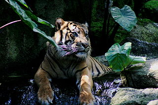
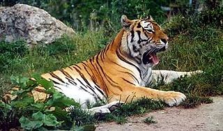
The fauna of Indonesia is characterised by high levels of biodiversity and endemicity due to its distribution over a vast tropical archipelago. Indonesia divides into two ecological regions; western Indonesia which is more influenced by Asian fauna, and the east which is more influenced by Australasian species.

The flora consists of many unique varieties of tropical plants. Blessed with a tropical climate and roughly 17,000 islands, Indonesia is the nation with the second highest biodiversity in the world. The flora of Indonesia reflects an intermingling of Asian, Australian and unique, Indonesian lineages. This is due to the geography of Indonesia, located between the aforementioned continents. The archipelago consists of a variety of regions, from the tropical rain forests of the northern lowlands and the seasonal forests of the southern lowlands through the hill and mountain vegetation, to subalpine shrub vegetation. With the second longest coastline in the world, Indonesia also has many swamps and other varieties of coastal vegetation. Combined, these all give rise to a huge floral biodiversity. There are about 28,000 species of flowering plants documented in Indonesia, including 2500 orchids, 122 species of bamboo, over 350 species of rattan and 400 species of Dipterocarpus, including ebony, sandalwood and teakwood. Indonesia is also home to some unusual species of carnivorous plants. One exceptional species is known as Rafflesia arnoldi, named after Sir Thomas Stamford Raffles and Dr. Thomas Arnold, who discovered the flower in the depths of Bengkulu, southwest Sumatra. This parasitic plant has the largest flower of any plant, does not produce leaves and grows only on one species of liana on the rainforest floor. Another unusual plant is Amorphophallus titanum from Sumatra. Numerous species of insect trapping pitcher plants can also be found in Borneo, Sumatra, and other islands of the Indonesian archipelago. There are a staggering 6000 traditional medicinal plants used as Jamu.,
All of the animals living in Asia and its surrounding seas and islands are considered the fauna of Asia. Since there is no natural biogeographic boundary in the west between Europe and Asia, the term "fauna of Asia" is somewhat elusive. Temperate Asia is the eastern part of the Palearctic realm, and its south-eastern part belongs to the Indomalayan realm. Asia shows a notable diversity of habitats, with significant variations in rainfall, altitude, topography, temperature and geological history, which is reflected in its richness and diversity of animal life.

The Central Indo-Pacific is a biogeographic region of Earth's seas, comprising the tropical waters of the western Pacific Ocean, the eastern Indian Ocean, and the connecting seas.

The Borneo lowland rain forests is an ecoregion, within the tropical and subtropical moist broadleaf forests biome, of the large island of Borneo in Southeast Asia. It supports approximately 15,000 plant species, 380 bird species and several mammal species. The Borneo lowland rain forests is diminishing due to logging, hunting and conversion to commercial land use.
New Guinea, lying within the tropics and with extensive mountain areas, comprises a wide range of ecoregions. These include rainforests, grasslands and mangrove.

The Lesser Sunda Islands, also known as Nusa Tenggara Islands, are an archipelago in Maritime Southeast Asia. Most of the Lesser Sunda Islands are located within the Wallacea region, except for the Bali province which is west of the Wallace Line and is within the Sunda Shelf. Together with the Greater Sunda Islands to the west they make up the Sunda Islands. The islands are part of a volcanic arc, the Sunda Arc, formed by subduction along the Sunda Trench in the Java Sea. Slightly over 20 million people live on the islands. Etymologically, Nusa Tenggara means "Southeast Islands" from the words of nusa which means 'island' from Old Javanese language and tenggara means 'southeast'.

The Sulawesi lowland rain forests is a tropical moist forest ecoregion in Indonesia. The ecoregion includes the lowlands of Sulawesi and neighboring islands.

The Sulawesi montane rain forests is a tropical moist forest ecoregion in Indonesia. It includes the highlands of Sulawesi.
The Eastern Java–Bali montane rain forests ecoregion covers the higher altitude mountain rainforests on the eastern side of the island of Java, and most of the center of the island of Bali in Indonesia. The region has a number of active volcanoes, but is under pressure from growing human populations pushing into higher elevations and more marginal land. With elevations rising from sea level to 3,426 metres (11,240 ft), and precipitation varying between rainforest and drier forest levels, the area has many different forest types – evergreen, deciduous and semi-alpine.
References
- Wikramanayake, Eric; Eric Dinerstein; Colby J. Loucks; et al. (2002). Terrestrial Ecoregions of the Indo-Pacific: a Conservation Assessment. Island Press; Washington, DC.
- Freshwater Ecoregions of the World
- Abell, R., Michele L. Thieme, Carmen Revenga, Mark Bryer et al. "Freshwater Ecoregions of the World: A New Map of Biogeographic Units for Freshwater Biodiversity Conservation". Bioscience Vol. 58 No. 5, May 2008, pp. 403-414.
- Spalding, Mark D., Helen E. Fox, Gerald R. Allen, Nick Davidson et al. "Marine Ecoregions of the World: A Bioregionalization of Coastal and Shelf Areas". Bioscience Vol. 57 No. 7, July/August 2007, pp. 573–583.