Northern New Guinea lowland rain and freshwater swamp forests

Last updated
Northern New Guinea lowland rain and freshwater swamp forests
Sago (Metroxylon sagu) in New Guinea.jpg
Sago palms ( Metroxylon sagu ) in East Sepik Province, Papua New Guinea
Ecoregion AA0115.png
Ecoregion territory (in purple)
Ecology
Realm Australasian realm
Biome tropical and subtropical moist broadleaf forests
Borders
Geography
Area134,543 km2 (51,947 sq mi)
Countries
Provinces
Coordinates 3°55′S142°19′E / 3.92°S 142.32°E / -3.92; 142.32 Coordinates: 3°55′S142°19′E / 3.92°S 142.32°E / -3.92; 142.32
Conservation
Conservation status Relatively stable/intact
Protected15,323 km² (11%) [1]

The Northern New Guinea lowland rain and freshwater swamp forests is a tropical moist broadleaf forest ecoregion of northern New Guinea. [2] [3] [4]

Contents

Setting

The Northern New Guinea lowland rain and freshwater swamp forests extend across the northern lowlands of the island of New Guinea, lying between the New Guinea Central Range to the south and the Pacific Ocean to the north. It extends from the eastern shore of Cenderawasih Bay in Indonesia's Papua Province east to Morobe Province of Papua New Guinea. [5]

Several east-west mountain ranges, including the Van Rees Mountains, Foja Mountains, Torricelli Mountains, and Finisterre Mountains, rise from the lowlands; these ranges are home to the distinct Northern New Guinea montane rain forests ecoregion.

The ecoregion is drained by several of New Guinea's large rivers, including the Mamberamo, Sepik, and Ramu, and Markham.

Flora

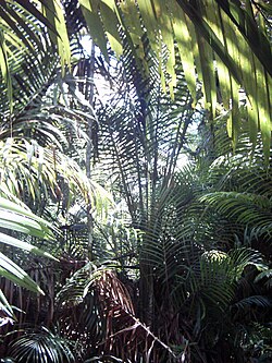
The plant communities of the ecoregion are diverse. Lowland evergreen rain forest is the most extensive, and includes alluvial forests in the plains, and hill forests in the foothills of the adjacent mountains.[ citation needed ]

There are extensive freshwater swamp forests in the coastal lowlands and in the Lakes Plains region between the Van Rees-Foja mountains and the Central Range. The swamp forest habitats are diverse, and include grass swamps, swamp savannas, and swamp woodlands and forests dominated by Melaleuca , sago palm (Metroxylon sagu), Pandanus , Campnosperma , and/or Terminalia . [6]

Fauna

The ecoregion corresponds to the Northern Papuan lowlands Endemic Bird Area. Limited-range and endemic species include the red-breasted paradise kingfisher (Tanysiptera nympha), brown lory (Chalcopsitta duivenbodei), Edwards's fig parrot (Psittaculirostris edwardsii), Salvadori's fig parrot (Psittaculirostris salvadorii), Brass's friarbird (Philemon brassi), white-bellied whistler (Pachycephala leucogastra), brown-headed crow (Corvus fuscicapillus), pale-billed sicklebill (Drepanornis bruijnii), and banded yellow robin (Gennaeodryas placens). [7]

Conservation and threats

A 2017 assessment found that 15,323 km², or 11%, of the ecoregion is in protected areas. [1] The largest is Mamberamo Foja Wildlife Reserve, which extends along the Mamberamo River and its tributaries the Tariku and Taritatu from the foothills of the Central Range to the sea, including the Foja Mountains.

Related Research Articles

<span class="mw-page-title-main">Solomon Islands rain forests</span>

The Solomon Islands rain forests are a terrestrial ecoregion covering most of the Solomon Islands archipelago.

<span class="mw-page-title-main">Mamberamo River</span> River in Indonesia

The Mamberamo is the second longest river on the island of New Guinea, after Sepik River and third largest in Oceania by discharge volume after Fly River and Sepik. It is located in the Indonesian province of Papua. It is the second largest river in Indonesia by volume of discharge after Kapuas River and also the widest.

<span class="mw-page-title-main">Foja Mountains</span>

The Foja Mountains are located just north of the Mamberamo river basin in Papua, Indonesia. The mountains rise to 2,193 metres (7,195 ft), and have 3,000 square kilometers of old growth tropical rainforest in the interior part of the range. The Foja forest tract covers 9,712 square kilometers and is the largest tropical forest without roads in the Asia Pacific region.

The Torricelli Mountains are a mountain range in Sandaun Province, north-western Papua New Guinea. The highest peak in the range is Mount Sulen at 1650 meters. The Bewani Mountains are located to the west, and the Prince Alexander Mountains are located to the east. To the north, the mountains slope down to the Pacific Ocean, and to the south lies the basin of the Sepik River. Named after the Italian physicist and mathematician Evangelista Torricelli during the German colonial period.

The Prince Alexander Mountains are a mountain range in Papua New Guinea. The range is located on the northern coast of New Guinea. The Torricelli Mountains lie to the west, and the basin of the Sepik River lies to the south. Mount Turu is a notable peak, located towards the eastern end of the range.

<span class="mw-page-title-main">Central Range montane rain forests</span> Ecoregion in New Guinea

The Central Range montane rain forests is a tropical moist forest ecoregion on the island of New Guinea. The ecoregion covers the Central Range of the New Guinea Highlands, which extends along the spine of the island. The montane rain forests of the ecoregion are distinct from the surrounding lowland forests, and are home to many endemic plants and animals.

<span class="mw-page-title-main">Huon Peninsula montane rain forests</span>

The Huon Peninsula montane rain forests is a tropical moist forest ecoregion in New Guinea. The ecoregion covers the mountains of northeastern New Guinea's Huon Peninsula.

New Guinea, lying within the tropics and with extensive mountain areas, comprises a wide range of ecoregions. These include rainforests, grasslands and mangrove.

<span class="mw-page-title-main">Sulawesi lowland rain forests</span> Ecoregion in Sulawesi, Indonesia

The Sulawesi lowland rain forests is a tropical moist forest ecoregion in Indonesia. The ecoregion includes the lowlands of Sulawesi and neighboring islands.

<span class="mw-page-title-main">Vogelkop–Aru lowland rain forests</span> Ecoregion in Indonesia

The Vogelkop–Aru lowland rain forests is a tropical moist forest ecoregion in Indonesia. The ecoregion covers the peninsular lowlands of western New Guinea, along with the Aru Islands and other nearby islands.

<span class="mw-page-title-main">Vogelkop montane rain forests</span> Ecoregion in New Guinea

The Vogelkop montane rain forests is a tropical moist forest ecoregion in western New Guinea. The ecoregion covers the mountains of western New Guinea's Bird's Head and Bomberai peninsulas.

<span class="mw-page-title-main">New Britain–New Ireland lowland rain forests</span>

The New Britain-New Ireland lowland rain forests is a tropical moist forest ecoregion in Papua New Guinea. The ecoregion covers the lowland rain forests of New Britain, New Ireland, and nearby islands in the Bismarck Archipelago.

<span class="mw-page-title-main">New Britain–New Ireland montane rain forests</span>

The New Britain-New Ireland montane rain forests is a tropical moist forest ecoregion in Papua New Guinea. The ecoregion includes the mountain rain forests on the islands of New Britain and New Ireland, which lie northeast of New Guinea.

<span class="mw-page-title-main">Northern New Guinea montane rain forests</span> Ecoregion in New Guinea

The Northern New Guinea montane rain forests is a tropical moist forest ecoregion in northern New Guinea. The ecoregion covers several separate mountain ranges lying north of New Guinea's Central Range and south of the Pacific Ocean.

<span class="mw-page-title-main">Mamberamo Foja Wildlife Reserve</span>

Mamberamo Foja Wildlife Reserve is a large protected area on New Guinea, in Indonesia's Papua Province. It covers an area of 16,610 km², and extends along the Mamberamo River and its tributaries from the foothills of the Central Range to the Pacific Ocean.

<span class="mw-page-title-main">Southeastern Papuan rain forests</span>

The Southeastern Papuan rain forests is a tropical moist forest ecoregion in southeastern New Guinea. The ecoregion covers the mountainous center and coastal lowlands of the Papuan Peninsula.

<span class="mw-page-title-main">Southern New Guinea lowland rain forests</span> Ecoregion in New Guinea

The Southern New Guinea lowland rain forests is a tropical moist forest ecoregion in southeastern New Guinea. The ecoregion covers portions of New Guinea's southern lowlands.

<span class="mw-page-title-main">Southern New Guinea freshwater swamp forests</span> Ecoregion in New Guinea

The Southern New Guinea freshwater swamp forests is a tropical moist forest ecoregion in southern New Guinea. The ecoregion includes the extensive swamp forests of southern and western New Guinea.

References

  1. 1 2 Eric Dinerstein, David Olson, et al. (2017). An Ecoregion-Based Approach to Protecting Half the Terrestrial Realm, BioScience, Volume 67, Issue 6, June 2017, Pages 534–545; Supplemental material 2 table S1b.
  2. "Map of Ecoregions 2017". Resolve. Retrieved August 20, 2021.
  3. "Northern New Guinea lowland rain and freshwater swamp forests". Digital Observatory for Protected Areas. Retrieved August 20, 2021.
  4. "Northern New Guinea lowland rain and freshwater swamp forests". The Encyclopedia of Earth. Retrieved August 20, 2021.
  5. Wikramanayake, Eric; Eric Dinerstein; Colby J. Loucks; et al. (2002). Terrestrial Ecoregions of the Indo-Pacific: a Conservation Assessment. Island Press; Washington, DC.
  6. "Northern New Guinea lowland rain and freshwater swamp forests". Terrestrial Ecoregions. World Wildlife Fund.
  7. BirdLife International (2020) "Endemic Bird Areas factsheet: Northern Papuan lowlands." Downloaded from http://www.birdlife.org on 30/05/2020.