The Mamberamo (Indonesian: Sungai Mamberamo) is the second-longest river on the island of New Guinea, after Sepik River (1,126 km) and the second largest in Oceania by discharge volume after Fly. It is located in the Indonesian province of Papua. It is the second largest river in Indonesia by volume of discharge after Kapuas and also the widest.[3]
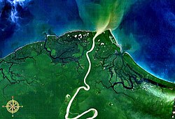
The river is formed from the confluence of its upper tributaries, the Tariku and Taritatu Rivers in the Lakes Plains region, an interior basin with extensive freshwater swamp forests and grasslands. It flows northwards between the Van Rees Range (Pegunungan Van Rees) and Foja Mountains through a series of rapids and gorges. The last 160 km of the river are navigable.[4] In the coastal lowlands, the river is lined with marshes and forms a broad river delta. The Mamberamo discharges into the Pacific Ocean at the northern point of Point D'Urville or Cape Narwaku (Tanjung Narwaku).
The river's huge valley is home to various uncontacted peoples and incredible biodiversity. In the 1990s, the Indonesian Government had plans to construct a large hydroelectric dam on the Mamberamo that would have submerged much of the area. This plan was shelved after the Indonesian financial crisis from 1998 to 1999, but there are concerns by environmental groups that it could be resurrected sometime in the future. At present, the Mamberamo remains the second largest river in the world to be completely unfragmented by dams in its catchment, behind only the relatively nearby Fly.[3]
The Mamberamo area also broadly refers to several nearby mountain ranges, including the Van Rees and Foja Mountains (also known as Foya), which were the subject of a recent rapid biological assessment conducted by Conservation International, the Indonesian Institute of Sciences, and Cenderawasih University. The scientific team discovered the first new bird species from New Guinea in 60 years, and a wealth of other new plants and animals. The Foya Mountains appear to be a globally outstanding repository of biodiversity.
Hydrology
Its length from the confluence of the Tariku and Taritatu is 283km (176mi). From the source of the Waruta, it covers a total distance of 1,112km (691mi). It has a catchment area of 79,000km2 (31,000sqmi) with an annual rainfall of 3,578 mm (Köppen climate classification classifies this area as type Af). Average width is 175–800m (574–2,625ft), depth 8m (26ft) (maximum 33 m).[5][6][1]
The region is geologically young (middle to late Miocene, i.e. less than 15 million years old) and remains tectonically active, with frequent earthquakes and landslides in the steepest areas. The mountain basin called "Mamberamo" is composed mostly of high floodplains, extensive swamps, forested wetlands, meandering rivers and backwater lakes. The sediment-rich rivers in the catchment belong to 'white-water' systems similar to the Amazonian moors. Three soil orders are present, of which the inceptisols are the most widespread, followed by ultisols and entisols. All soils are fine textured with poor drainage. The diversity of the region is a result of its geological history, which gives rise to a diversity of habitats. Riparian forests within the Mamberamo Basin are heavily influenced by dynamic river meanders that continually modify the landscape, with some banks eroding rapidly while others grow as new sediments accumulate.[11]
Ecology and vegetation
The Mamberamo Basin is one of the most important biodiversity hotspots in New Guinea. Both Asian and Australo-Pacific elements are present in terms of botanical affinities. One survey at the foothills of the Foja Mountains identified 487 putative plant species, 156 of which are not assigned to known taxa, indicating a high proportion of undescribed species. The floodplain forests of the basin include swamp forests, seasonally flooded lakeside forests and sago forests.
The upper Mamberamo River was photographed during the Central-North New Guinea Expedition led by Le Roux
In 1545, the Spanish navigator Iñigo Ortiz de Retes sailed along the northern coast of the island as far as the mouth of this river that he charted as San Agustín. At this spot, on 20 June 1545, he claimed the territory for the Spanish Crown, and in the process bestowed the name to the island (Nueva Guinea) by which it is known today.
The first European to enter the mouth of the Mamberamo was Dutchman Dr D. F. van Braam Morris in 1883. The residents from the northern Moluccas (Ternate) rowed up the river to ascertain that it was navigable by steamer.[12] The following year in 1884 Van Braam Morris returned to the steamship Havik and travelled 60mi (97km) (as the crow flies) along its course.[13]
The Mamberamo Foja Wildlife Reserve covers an area of 16,610km2, extending along the Mamberamo and its major tributaries from the Central Range foothills to the Pacific Ocean. It encompasses the central Lakes Plains region and extends southwards along the eastern side of the river to include the Foya Mountains, the river delta, and the sea.[14]
Mamberamo Bridge
The Mamberamo Bridge was the second longest cable-stayed span in Indonesia after Kutai Kartanegara Bridge with 235 meters and 270 meters respectively until the latter bridge collapsed in November 2011.
↑ (in Dutch)'Nieuw Guinea', in de De Locomotief, donderdag 5 maart 1885 no. 57. Visited 2 July 2013
↑ Petocz, Ronald G. (1989). Conservation and Development in Irian Jaya: A Strategy for Rational Resource Utilization. Brill, 1989.
This article incorporates text by Douglas Sheil, Manuel Boissière, Miriam van Heist, Ismail Rachman, Imam Basuki, Meilinda Wan, and Yoseph Watopa available under the CC BY 4.0 license.
External links
Souter, Gavin (1963). New Guinea: The Last Unknown. Angus & Robertson. ISBN0-207-94627-2.
This page is based on this Wikipedia article Text is available under the CC BY-SA 4.0 license; additional terms may apply. Images, videos and audio are available under their respective licenses.