Major rivers in Flores
List of rivers flowing in the island of Flores, East Nusa Tenggara province, Indonesia. [1]
List of rivers flowing in the island of Flores, East Nusa Tenggara province, Indonesia. [1]

Borneo is the third-largest island in the world, with an area of 748,168 km2 (288,869 sq mi). Situated at the geographic centre of Maritime Southeast Asia, it is one of the Greater Sunda Islands, located north of Java, west of Sulawesi, and east of Sumatra.

An island or isle is a piece of subcontinental land completely surrounded by water. Very small islands such as emergent land features on atolls can be called islets, skerries, cays or keys. An island in a river or a lake island may be called an eyot or ait, and a small island off the coast may be called a holm. Sedimentary islands in the Ganges Delta are called chars. A grouping of geographically or geologically related islands, such as the Philippines, is referred to as an archipelago.

Sumatra is one of the Sunda Islands of western Indonesia. It is the largest island that is fully within Indonesian territory, as well as the sixth-largest island in the world at 475,807.63 km2 (182,812 mi.2), including adjacent islands such as the Simeulue, Nias, Mentawai, Enggano, Riau Islands, Bangka Belitung and Krakatoa archipelago.
Java is one of the Greater Sunda Islands in Indonesia. It is bordered by the Indian Ocean to the south and the Java Sea to the north. With a population of 151.6 million people, Java is the world's most populous island, home to approximately 56% of the Indonesian population. Indonesia's capital city, Jakarta, is on Java's northwestern coast.
Paterson Inlet / Whaka a Te Wera is a large natural harbour in the eastern coast of Stewart Island/Rakiura, New Zealand, much of which is unspoilt forest.
The International School for Advanced Studies is an international, state-supported, post-graduate-education and research institute in Trieste, Italy.

New Guinea is the world's second-largest island, with an area of 785,753 km2 (303,381 sq mi). Located in Melanesia in the southwestern Pacific Ocean, the island is separated from Australia by the 150-kilometre wide Torres Strait, though both landmasses lie on the same continental shelf, and were united during episodes of low sea level in the Pleistocene glaciations as the combined landmass of Sahul. Numerous smaller islands are located to the west and east. The island's name was given by Spanish explorer Yñigo Ortiz de Retez during his maritime expedition of 1545 due to the resemblance of the indigenous peoples of the island to those in the African region of Guinea.

The following is an alphabetical list of topics related to the Republic of Indonesia.
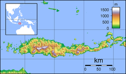
The Wera River is a river of Flores, East Nusa Tenggara province, Indonesia, about 1500 km east of the capital Jakarta.
The Sissa River is a river of Flores, East Nusa Tenggara, Indonesia. The 87-km river flows from a southwest to northeast direction, with the upstream at Mount Inielika north of Bajawa, Ngada Regency, and discharges into the Flores Sea near Mbay, Nagekeo Regency.
Wera may refer to:
Te Wera Hauraki (?–1839) a rangatira (chieftain) of the Ngāti Hineira and Te Uri Taniwha hapū of the Ngāpuhi iwi from the Northland region of New Zealand. From about 1818 to 1821, Te Wera went on expeditions and fought battles in the Bay of Plenty and the East Coast. In 1823, he was one of the leaders of the Ngāpuhi attack which defeated Te Arawa at Mokoia island on Lake Rotorua. Following the attack, Te Wera and his wife, Te Ao-kapurangi, negotiated a peace that prevented Ngāpuhi from taking further action against Te Arawa. After the conclusion of peace, he continued east and settled at Māhia Peninsula in Hawke's Bay, where he allied with Te Whareumu of Ngāti Rakaipaaka and Ngāti Hikairo and Te Pareihe of Ngāti Te Whatuiāpiti, helping them to fight off incursions from other tribes, especially Ngāti Te Ūpokoiri and Ngāti Raukawa. He remained at Māhia until his death in 1839.
WERA-LP is a Variety formatted broadcast radio station licensed to Arlington, Virginia, serving Arlington and Alexandria in Virginia and Washington, D.C. WERA-LP is owned and operated by Arlington Independent Media, the nonprofit that created the radio station.
Sissa may refer to:

Ulva Island-Te Wharawhara Marine Reserve is a marine reserve covering an area of 1,075 hectares south-west and north-east of Ulva Island, in the Paterson Inlet of New Zealand's Stewart Island. It was established in 2004 and is administered by the Department of Conservation.