WikiMili
List of rivers of Bali
Last updated
June 21, 2025
List of
rivers
flowing in the island of
Bali
,
Indonesia
.
[
1
]
Contents
In alphabetical order
See also
References
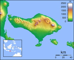
Topography of Bali
In alphabetical order
Ayung River
Sungi River
Telaga Waja River
See also
Drainage basins of Bali
List of drainage basins of Indonesia
List of bodies of water in Bali
List of rivers of Indonesia
List of rivers of Lesser Sunda Islands
References
↑
Map of Indonesia
. Peta Indonesia. Wawasan Nusantara. CV. Indo Prima Sarana. Accessed 29 Juli 2017.
v
t
e
Rivers
of
Bali
Ayung
Sungi
Telaga Waja
Rivers of Indonesia
v
t
e
Major
rivers
in
Indonesia
Sumatra
Aceh
Asahan
Silau
Banyuasin
Barumun
Batang Hari
Merangin
Tembesi
Gadis
Indragiri
Ombilin
Sinamar
Jamboaye
Kampar
Kampar Kanan
Kluet
Kualu
Mesuji
Musi
Komering
Ogan
Rawas
Simpang-kanan
Peureulak
Peusangen
Renun
Rokan
Kumu
Rokan-kanan
Rokan-kiri
Sekampung
Seputih
Siak
Mandau
Simpang-kiri
Tamiang
Teunom
Toru
Tripa
Tulangbawang
Tungkal
Wampu
Bohorok
Woyla
Java
Bengawan Solo
Bodri
Brantas
Kali Mas
Porong
Widas
Ci Durian
Ci Kaengan
Ci Liwung
Ci Mandiri
Ci Manuk
Ci Sadane
Ci Anten
Ci Tanduy
Ci Tarum
Ci Ujung
Progo
Opak
Pemali
Sanen
Serang
Serayu
Kalimantan
Barito
Alalak
Kapuas (Barito)
Kahayan
Kapuas
Melawi
Sekayam
Kayan
Lamandau
Arut
Mahakam
Lawa
Mendawai
Pawan
Pembuang
Sampit
Sesayap
Sulawesi
Bongka
Jeneberang
Kalaena
Karama
Lalindu
Lariang
Lasolo
Mamasa
Manado
Marisa
Paguyaman
Palu
Pangkajene
Poso
Sadang
Sampara
Walanae
Lesser Sunda Islands
Bali
:
Ayung
,
Sungi
,
Telaga Waja
Lombok
:
Babak
,
Dodokan
,
Jangkok
Flores
:
Sissa
,
Wera
Sumbawa
:
Brang Biji
,
Moyo
Sumba
:
Kadassa
,
Kadumbul
,
Kambaniru
,
Melolo
,
Polapare
West Timor
:
Benanain
,
Mina
,
Noel Besi
,
Pono
Maluku
Eti
Kawa
Masiwang
Sapalewa
Salawai
Tala
Waeapo
Western Papua
Bian
Bulaka
Digul
Kamundan
Kumbe
Lorentz
Mamberamo
Sobger
Songgato
Tariku
Taritatu
Van Daalen
Waruta
Mapi
Maro
Momats
Muturi
Pulau
Kampung
Vriendschaps
Seremuk
Tabai
Wamma
Warenai
Wapoga
Wiriagar
This page is based on this
Wikipedia article
Text is available under the
CC BY-SA 4.0
license; additional terms may apply.
Images, videos and audio are available under their respective licenses.