
The Barito River is the second longest river in Borneo after the Kapuas River with a total length of 1,090 km (680 mi) and a drainage basin of over 80,000 km2 (31,000 sq mi) in South Kalimantan, Indonesia. It originates in the Müller Mountain Range, from where it flows southward into the Java Sea. Its most important affluent is the Negara and Martapura, and it passes through the city of Banjarmasin.

The Brantas is the longest river in East Java, Indonesia. It has a length of 320 km, and drains an area of over 11,000 km2 from the southern slope of Mount Kawi-Kelud-Butak, Mount Wilis, and the northern slopes of Mount Liman-Limas, Mount Welirang, and Mount Anjasmoro. Its course is semi-circular or spiral in shape: at its source, the river heads southeast, but gradually curves south, then southwest, west, then north, and finally it flows generally eastward at the point where it branches off to become the Kalimas and Porong River.
Sekayam River is a river of Borneo, West Kalimantan province, Indonesia. It is a tributary of the Kapuas River. The Public Forest System Utility Program has a scheme on the river aimed at reducing the level of mercury content absorbed by humans.
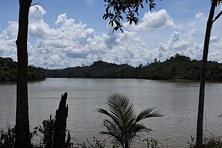
Mendawai River or Katingan River is a river of Borneo, it is located in Central Kalimantan, Indonesia. With a total length of 616 km (383 mi). The longhouses of the Pendahara are located along the river in its upper course. The river has its source in the Schwaner Mountain Range.
Berau River is a river of East Kalimantan, Indonesia, about 300 kilometers north of the provincial capital Samarinda. Tributaries include the Kelai River.
The Kayan River is a river of Borneo island, flowing in the North Kalimantan province of Indonesia, about 1,600 km northeast of the capital Jakarta. Tributaries include the Bahau River.
The Wera River is a river of Flores, East Nusa Tenggara province, Indonesia, about 1500 km east of the capital Jakarta.
Liman river or Ci Liman is the name of a river located at the western tip of Java Island, Banten Province, Indonesia. It originates from its headwaters in the southern mountains of Banten, around the Sareweh in the Lebak Regency, near the settlement of the Baduy Dalam tribe. It flows westward towards the coast in the Panimbang, region of Pandeglang and empties into Lada Bay, the Sunda Strait. It is approximately 73 km from the center of Cilegon city to the mouth of the river.

Asem River is a river in northern West Java province on Java island, Indonesia. The river rises on Mount Tangkuban Perahu and discharges into the Bay of Ciasem, Java Sea, traversing Ciasem, Subang Regency, around 90 km east of the capital Jakarta.
The Baliung River is a river flowing in southern Java, within the Banten province, Indonesia. The upstream starts in the southern mountains of Java; it flows southward into the Indian Ocean, about 130 kilometres (81 mi) southwest of Jakarta.
Mandiri River is a river in southwestern Java of West Java province, Indonesia. It flows mainly in the Sukabumi Regency.
Buni River is a river in southern West Java, Indonesia. The 109-km-long river flows in the Bandung and Cianjur regencies, with the upstream at the west slope of Mount Patuha and discharge into the Indian Ocean.
The Progo River is a river in southern central Java, Indonesia. The river passes through two provinces; Central Java and Yogyakarta Special Region. The source of the river is on the slopes of Mount Sindoro, Central Java.
The Wiriagar or AimauRiver is a river in southern West Papua province, Indonesia.

The Jamboaye River is a river in the province of Aceh in northern Sumatra, Indonesia, about 1,600 km northwest of the capital Jakarta.
Ci Kaengan is a river in the island of Java, Indonesia, that flows mainly in the Garut Regency of West Java province, about 210 km to the southeast of the capital Jakarta.

The Comal River is a river in Jawa Tengah, Indonesia. It rises in the North Serayu Mountains from Mount Slamet. The river has a length of around 109.18 km flowing from south to north, ending in Java Sea. It is the largest river in Pemalang Regency, Central Java, and flows through seven districts within that regency.
Mayang River or Kali Mayang is a river located in the south of East Java and flows into the Indian Ocean at a cape in Watuulo, Jember Regency, in the southern coastal area of Java. The river originates in the southwest of Mount Raung. It has a length of approximately 146 km (91 mi) and a watershed area covering 1,113 km2 (430 sq mi).
The Cihara is a river located in the Lebak Regency of Banten, Java, Indonesia.


