
This is a list of rivers flowing in the province of Banten, Indonesia. [1] [2]
This is a list of rivers flowing in the province of Banten, Indonesia. [1] [2]
In Banten Province there are four river regions (Indonesian: Wilayah Sungai); two of them are under the authority of Banten Province, i.e. Ciliman-Cibungur and Cibaliung-Cisawarna, whereas the other two are under the authority of the central government, i.e. Cidanau-Ciujung-Cidurian and Ciliwung-Cisadane. [3]
The government of Banten Province has the authority over 102 watershed areas (Indonesian: Daerah Aliran Sungai), including 75 areas in the Cibaliung Cisawarna river region and 27 other in Ciliman Cibungur river region. [4]
The watershed areas and the river regions in Banten Province are as follows:
The Mina River is a river of Timor, in the province of East Nusa Tenggara, Indonesia, about 2000 km east of the capital Jakarta. Above this river also stretches the Noelmina Bridge which connects Kupang with the South Central Timor Regency.
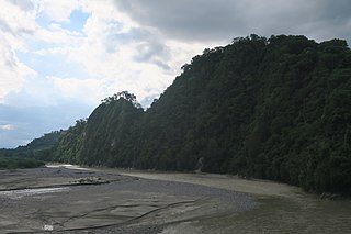
Liman river or Ci Liman is the name of a river located at the western tip of Java Island, Banten Province, Indonesia. It originates from its headwaters in the southern mountains of Banten, around the Sareweh in the Lebak Regency, near the settlement of the Baduy Dalam tribe. It flows westward towards the coast in the Panimbang, region of Pandeglang and empties into Lada Bay, the Sunda Strait. It is approximately 73 km from the center of Cilegon city to the mouth of the river.

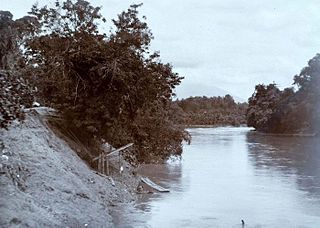
The Cisadane River is a 138 kilometres (86 mi) long river in northern West Java, Indonesia. Note that the prefixed syllable "Ci" means river, so to avoid tautology the true translation is "Sadane River". The river has its source at Mount Pangrango and passes through Bogor and Tangerang before flowing to the Java Sea.

Asem River is a river in northern West Java province on Java island, Indonesia. The river rises on Mount Tangkuban Perahu and discharges into the Bay of Ciasem, Java Sea, traversing Ciasem, Subang Regency, around 90 km east of the capital Jakarta.
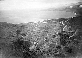
The Baliung River is a river flowing in southern Java, within the Banten province, Indonesia. The upstream starts in the southern mountains of Java; it flows southward into the Indian Ocean, about 130 kilometres (81 mi) southwest of Jakarta.
Mandiri River is a river in southwestern Java of West Java province, Indonesia. It flows mainly in the Sukabumi Regency.
Paguyaman River is a river in Gorontalo (province), Sulawesi island, Indonesia, about 1900 km northeast of capital Jakarta.

The Angke River is a 91.25-kilometre (56.70 mi) long river in Jakarta, Indonesia. The river flows from the Bogor area of West Java, passing through the cities of Tangerang (Banten) and Jakarta into the Java Sea via the Cengkareng Drain. The river is connected with the Cisadane River by the Mookervaart Canal.
The Grogol River is a small river in the western part of the Special Capital Region of Jakarta, Indonesia. The lower portions of the original river have been channelized with levees built along its banks, but flooding remains a real concern. Illegal buildings built along its banks were removed in 2014, and fifty-eight village families were provided with replacement housing, but most of them could not be accommodated.
The Ciujung is a river in the province of West Java and Banten on the island of Java, Indonesia.
Ci Kaengan is a river in the island of Java, Indonesia, that flows mainly in the Garut Regency of West Java province, about 210 km to the southeast of the capital Jakarta.
The Krukut River is a river flowing in Jakarta originating in Bogor Regency. In the past the river was clean and one of the tourist attractions during the Dutch East Indies administration, but due to denser housing on the banks and lack of maintenance, the water turned dark and filled with trash, causing routine flooding in rainy seasons.
Cakung River is a river in the Bekasi, West Java, and the eastern part of the Special Capital Region of Jakarta, Indonesia. The lower portions of the original river have been channelized and directed into the eastern flood canal, "Banjir Kanal Timur", which continues to flow to the Java Sea in the district of Marunda, Cilincing, North Jakarta. The river regularly causes flooding in the cities of Bekasi and Jakarta.
The Buaran River is a river flowing in the Bekasi, West Java, and the eastern part of the Special Capital Region of Jakarta, Indonesia. The lower portions of the original river have been channelized and directed into the eastern flood canal, "Banjir Kanal Timur", which continues to flow to the Java Sea in the district of Marunda, Cilincing, North Jakarta. The river regularly causes flooding in the cities of Bekasi and Jakarta.
Baru Timur River is a man-made canal flowing from Ci Liwung in Bogor Regency to Jakarta, Indonesia. It was one of two canals built in the 18th century under the order of Governor-General Gustaaf Willem van Imhoff originally to transport agricultural harvest from Bogor to Batavia. Currently, both canals, now known as Kali Baru Timur and Kali Baru Barat, are among the main rivers in Jakarta, and part of the Ciliwung Cisadane flood control project. Baru Timur River flows from the Katulampa flood gate, built at the same time as the canal, along the major road Bogor Highway, passing Cimanggis, Depok, Cilangkap, until reaching the Java Sea in Kali Besar, Tanjung Priok, North Jakarta.
The Baru Barat River is a man-made canal flowing from the Cisadane River in Bogor Regency to Jakarta, Indonesia. It was one of two canals built in the 18th century under the order of the Governor-General Gustaaf Willem van Imhoff, the other being the Baru Timur River. Both canals were originally built to transport agricultural harvests from Bogor to Batavia. They are among the main rivers in Jakarta, and part of the Ciliwung Cisadane flood control project. The Baru Barat River flows through the districts of Pancoran and Tebet in South Jakarta and drains into the Banjir Kanal Barat.
Ciomas is a kecamatan in Bogor Regency, West Java, Indonesia. It is located near the provincial border with Banten, about 21 kilometers southwest of the regency capital Cibinong, and 3 kilometers west of the city center of Bogor. It borders Bogor Barat in the north, Bogor Selatan in the east, Tamansari in the south, and Dramaga in the west. In 2021, Ciomas has a total population of 172,336.
The Cihara is a river located in the Lebak Regency of Banten, Java, Indonesia.