The Liman River is a river in northern Java, Indonesia.

Asem River is a river in northern West Java province on Java island, Indonesia. The river rises on Mount Tangkuban Perahu and discharges into the Bay of Ciasem, Java Sea, traversing Ciasem, Subang Regency, around 90 km east of the capital Jakarta.

The Manuk River is a river in West Java, Indonesia, about 170 km east of the capital Jakarta.
Pemali River is a river in northern Central Java, Indonesia, about 250 km east of the capital Jakarta.
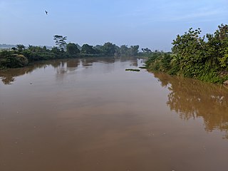
Serang River is a river in northern Central Java, Indonesia, about 400 km east of the capital Jakarta. The largest tributary is Lusi River, which discharges into Serang River after passing the city of Purwodadi.
Lusi River is a river in northern Central Java, Indonesia, about 400 km east of the capital Jakarta. It is a tributary of the Serang River, meeting after passing the city of Purwodadi.
The Porong River is a river flowing through Sidoarjo, East Java, Indonesia, about 700 km east of the capital Jakarta. It is one of the main distributary of the Brantas River that discharges into Bali Sea, close to the Madura Strait, and is the main outlet for the Lusi mudflow.
The Widas River is a river in northern East Java, Indonesia. It is a tributary of the Brantas River.
The Setail River is a river in southeastern Java, Indonesia.

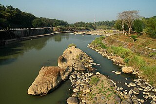
Kaso River, also Ci Kaso, is a river in Sukabumi Regency, West Java, Indonesia, about 140 km south of the capital Jakarta.

Buni River is a river in southern West Java, Indonesia. The 109-km-long river flows in the Bandung and Cianjur regencies, with the upstream at the west slope of Mount Patuha and discharge into the Indian Ocean.
The Laki River is a river in southern Java, Indonesia, about 160 kilometres (99 mi) south of the capital Jakarta. This river is the natural boundary between the Cianjur and Garut regencies.
The Progo River is a river in southern central Java, Indonesia. The river passes through two provinces; Central Java and Yogyakarta Special Region. The source of the river is on the slopes of Mount Sindoro, Central Java.
The Sanen River is a river in southern East Java province, Java island, Indonesia, about 800 km east of the capital Jakarta.
The Oyo River is a river in southern Central Java and Yogyakarta, in the central south area of Java island, Indonesia. It is a tributary of the Opak River.
Tungkal River is a river in Jambi province, Sumatra island, Indonesia, about 700 km northwest of the capital Jakarta.
The Bila River is a river in northern Sumatra, Indonesia, about 1200 km northwest of the capital Jakarta. It is a tributary of the Barumun River.
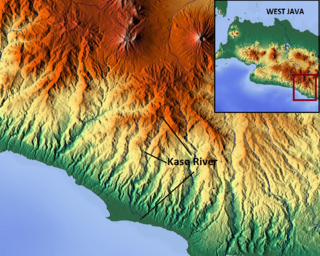
The Kaso River, also Ci Kaso, is a river in the Garut Regency of West Java, Indonesia, about 190 km southeast of the capital Jakarta. Coal-bearing sandstones, clays and limestones are typical geological traits of the Bandung area of southern Java. It flows past Pameungpeuk before flowing into the Indian Ocean.
The Tuntang is a major river of northern Central Java, Indonesia, about 400 km east of the capital Jakarta. It connects Lake Rawa Pening to the Java Sea, east of Semarang. There is a hydroelectric powerstation on the river near the lake.

The Ci Banten, or Ci Peteh, is a river in Banten province on the island of Java, Indonesia.

