Baru Timur River

Last updated
Baru Timur River
Kali Paseban, Kali Bluntas,
Kali Sentiong, Sungai Sentiong,
Kali Murtado
Map of rivers and canals in Jakarta 2012.jpg
Kali Baru Timur ("K. Baru Tmr"), bottom in the map of rivers and canals of Jakarta (2012)
Native nameKali Baru Timur (Indonesian)
Location
Country Indonesia
State Jakarta
Physical characteristics
Source 
  locationKatulampa, Bogor, West Java
Mouth Java Sea

Baru Timur River (Indonesian : Kali Baru Timur; Eastern New River) is a man-made canal flowing from Ci Liwung in Bogor Regency to Jakarta, Indonesia. [1] It was one of two canals built in the 18th century under the order of Governor-General Gustaaf Willem van Imhoff originally to transport agricultural harvest from Bogor to Batavia (now, Jakarta). [2] Currently, both canals, now known as Kali Baru Timur (Baru Timur River) and Kali Baru Barat (Baru Barat River), are among the main rivers in Jakarta, and part of the Ciliwung Cisadane flood control project. [3] Baru Timur River flows from the Katulampa flood gate, built at the same time as the canal, along the major road Bogor Highway, passing Cimanggis, Depok, Cilangkap, until reaching the Java Sea in Kali Besar, Tanjung Priok, North Jakarta. [4] [1]

Contents

Etymology

The name "Kali Baru" (New River) is connected to the fishing harbor in the Tanjung Priok area. In the 1960s, the harbor was established to replace the Kali Kresek Lahoa fishing harbor which was closed in 1967. The area was divided into two parts: Kalibaru Timur (Eastern Kali Baru) and Kalibaru Barat (Western Kali Baru). [5] Although the fishing harbor was closed in 1988, the harbor became a place to unload wood in Jakarta, but the name continues to be used for the rivers and areas. [6]

History

Baru Timur River between 1920 and 1932 COLLECTIE TROPENMUSEUM Kali Baru TMnr 60026229.jpg
Baru Timur River between 1920 and 1932

In 1739, the Dutch East Indies government under Governor General Van Imhoff built Oosterslokkan ("Eastern Canal") for irrigation and transportation of goods from inland. The canal was completed 14 years later, in 1753, but the effort to use it as a transportation way failed due to many leaks and the high cost of building multiple water gates. Finally, it is used only for irrigation. [7] There were three water gates to water the rice fields in the upstream areas of Ratim, Cibalok, and Cibanon. The water debit increased with the establishment of Katulampa Dam in Buitenzorg (Bogor) in 1749. The canal also supplied water to 9,075-hectare rice fields on the eastern side of Ci Liwung. [7]

In 1753, Oosterslokkan was lengthened to the eastern canal at Weltevreden (Lapangan Banteng), joining the Prapatan canal, to be known as "Kali Baru", and currently as "Kali Baru Timur" (Baru Timur River). As the eastern canal required high maintenance and repair costs, in 1776, Van Imhoff ordered the opening of another canal from the Cisadane River to flow into Ci Liwung. This canal was called Westerslokkan ("Western Canal"), and currently is called "Kali Baru Barat" (Baru Bart River). [2] [7] While the eastern canal was dug from Katulampa until Meester (Jatinegara) and received additional water supply from Cikeas River until Sunter River, the Westerslokkan or the eastern canal flowed from Cisadane River, passing Cipakancilan River, into the area of Kali Baru Barat, Matraman (Minangkabau River), and discharging into Banjir Kanal Barat. [8]

Since the 1960s, Kali Baru Timur contributed to the flood in the eastern part of Jakarta, which comprised the area of Sungai Sentiong Tanah Tinggi, Sumur Batu, Senen, Kali Baru Timur, and Percetakan Negara. [7]

In 1970 clear water flowed in Kali Baru Timur, allowing the white stones at the bottom to be seen, bordered by various trees at both banks. Various sweet water fish and shrimps lived in the river. Children swam and played in the water from Pondok Gede to the water gate of Kampung Gedong. [2] The water was used for irrigation, bathing, washing clothes, and source of drinking water. [2] However, in 1975, the condition changed drastically with the establishment of many factories along the Jalan Raya Bogor (Bogor Highway). As more workers settled in the area, rice fields were transformed into housing complexes. The river water became polluted by the waste discharges from the factories and garbage thrown by the inhabitants, so until today, the water is dark and dirty. [2]

Names

People live along the river from the border of Jakarta and Depok, until Cijantung, Cililitan, Cawang, and even Cipinang, generally calling the canal "Kali Baru Timur". [2] However, in Matraman or Pramuka, the river is called by various names. In Senen, Central Jakarta, it has been called Kali Paseban, Kali Bluntas, Kali Sentiong, or Kali Murtado. Those names are based on the village or roads passed by the stream. [2] The name "Kali Sentiong" is more popular in the area where Baru Timur River joins the Sentiong River before merging with Sunter River. [2]

Hydrology

Baru Timur River is grouped into the Eastern Area Stream Handling System of Jakarta, along with Cipinang, Sunter, Buaran, Jati Kramat and Cakung River, with a total entry debit at the upstream of 139 m3/sec and the downstream of 237 m3/sec, and the exit debit at the upstream of 39 m3/sec and the downstream of 40 m3/sec, from about 21 tributaries. [9] [10]

In 2016 it was observed that along Pasar Rebo, East Jakarta, the river condition was good with natural banks of stones, an inspection way, and trees along the river. In both banks, there were shopping and dining places. Until Cililitan, the stream narrowed, even flowed under Pusat Grosir Cililitan, one of the Cililitan shopping malls, until it 'reappeared' on the other side of the mall. [2] The stream briefly 'disappeared' again under the stapled interchanges of Cawang, East Jakarta. The width narrowed significantly after the trash filtering grid at the southern side of the Cawang interchanges, then flowing to the north direction passing the areas of Cipinang, Matraman, Salemba, and Johar Baru, until Kemayoran in Central Jakarta. In Kemayoran, the river joins the Sentiong River, then flows further to the north, joining the Ancol River before reaching the Java Sea. [2]

Geography

The river flows in the northwest area of Java with a predominantly tropical rainforest climate (designated as Af in the Köppen-Geiger climate classification). [11] The annual average temperature in the area is 27 °C. The warmest month is March, when the average temperature is around 30 °C, and the coldest is May, at 26 °C. [12] The average annual rainfall is 3674 mm. The wettest month is December, with an average of 456 mm of rainfall, and the driest is September, with 87 mm of rainfall. [13]

Normalisation

Baru Timur River is one of flooding sources in Jakarta, [14] mainly due to the accumulation of garbage thrown into the river. [15] The diving team of Indonesian Army helped to open the obstacles in the underground canal, opening the blocked 70 meter part of the 180-meter long water tunnel which connect the stream from Katulampa Bogor to the flood gate number 11 which divides the flow downstream to the Sentiong dan Ciliwung rivers. [15]

See also

Related Research Articles

<span class="mw-page-title-main">Ciliwung</span> River in Java, Indonesia

The Ciliwung is a 119km long river in the northwestern region of Java where it flows through two provinces, West Java and the special region of Jakarta. The natural estuary of the Ciliwung River, known as the Kali Besar, was an important strategic point for trade in the precolonial and colonial periods and was instrumental in the founding of the port city of Jakarta, but has been lost from a reorganization of the watercourse of the rivers around the area into canals.

<span class="mw-page-title-main">Jatinegara</span> District in East Jakarta, Indonesia

Jatinegara is one of the districts of the administrative city of East Jakarta, Indonesia. The name also refers to the larger, historic area of the colonial town of Meester Cornelis. Established in the 17th century, Jatinegara is one of the oldest areas in Jakarta, and contains a number of buildings from the colonial period.

<span class="mw-page-title-main">Tebet, South Jakarta</span> District in South Jakarta, Indonesia

Tebet is a district in the administrative city of South Jakarta, Indonesia. The boundaries of Tebet are Jend. Gatot Subroto-Letjen Haryono MT. tollway to the south, Ciliwung River to the east, Jalan Casablanca - Ciliwung River to the north, and Cideng River to the west. This district is home to SMA Negeri 8 Jakarta

<span class="mw-page-title-main">Floods in Jakarta</span> Flooding in Indonesia

Flooding in Jakarta occurs on the northwest coast of Java, at the mouth of the Ciliwung River on Jakarta Bay, which is an inlet of the Java Sea and has happened recently in 1996, 1999, 2007, 2013, and 2020.

<span class="mw-page-title-main">Jakarta Flood Canal</span> Channel in indonesia

The Jakarta Flood Canal refers to two canals that divert floods from rivers around Jakarta instead of going through the city. This first flood control channel was designed by Hendrik van Breen, an engineer working for the Dutch East Indian Department van Burgelijke Openbare Werken, after a big flood hit the city on 13 February 1918.

<span class="mw-page-title-main">Angke River</span> River in Jakarta, Indonesia

The Angke River is a 91.25-kilometre (56.70 mi) long river in Jakarta, Indonesia. The river flows from the Bogor area of West Java, passing through the cities of Tangerang (Banten) and Jakarta into the Java Sea via the Cengkareng Drain. The river is connected with the Cisadane River by the Mookervaart Canal.

<span class="mw-page-title-main">Grogol River</span> River in Indonesia

The Grogol River is a small river in the western part of the Special Capital Region of Jakarta, Indonesia. The lower portions of the original river have been channelized with levees built along its banks, but flooding remains a real concern. Illegal buildings built along its banks were removed in 2014, and fifty-eight village families were provided with replacement housing, but most of them could not be accommodated.

<span class="mw-page-title-main">Sunter River</span> River in Jakarta, Indonesia

The Sunter River or Kali Sunter is a river that flows in the eastern part of Jakarta, Indonesia. The river is about 37 km long and has 73,184,092 m2 of river basin. Neighborhoods along the Kali Sunter are very densely populated and prone to frequent flooding.

<span class="mw-page-title-main">Mookervaart River</span> River in Jakarta, Indonesia

The Mookervaart River is a canal connecting the Cisadane River in Tangerang and Kali Angke in Jakarta. Constructed from 1678 to 1689, this 25–30 meter wide channel is one of the important flood control water channels in Jakarta.

<span class="mw-page-title-main">Krukut River</span> River in Indonesia

The Krukut River is a river flowing in Jakarta originating in Bogor Regency. In the past the river was clean and one of the tourist attractions during the Dutch East Indies administration, but due to denser housing on the banks and lack of maintenance, the water turned dark and filled with trash, causing routine flooding in rainy seasons.

<span class="mw-page-title-main">Jatikramat River</span> River in Jakarta, Indonesia

The Jatikramat River is a river in Bekasi, West Java, and the eastern part of the Special Capital Region of Jakarta, Indonesia. The lower portions of the original river have been channelized and directed into the eastern flood canal, "Banjir Kanal Timur", which continues to flow to the Java Sea in the district of Marunda, Cilincing, North Jakarta. The river regularly causes flooding in the city of Bekasi and Jakarta.

<span class="mw-page-title-main">Cakung River</span> River in Java, Indonesia

Cakung River is a river in the Bekasi, West Java, and the eastern part of the Special Capital Region of Jakarta, Indonesia. The lower portions of the original river have been channelized and directed into the eastern flood canal, "Banjir Kanal Timur", which continues to flow to the Java Sea in the district of Marunda, Cilincing, North Jakarta. The river regularly causes flooding in the cities of Bekasi and Jakarta.

<span class="mw-page-title-main">Buaran River</span> River in Java, Indonesia

The Buaran River is a river flowing in the Bekasi, West Java, and the eastern part of the Special Capital Region of Jakarta, Indonesia. The lower portions of the original river have been channelized and directed into the eastern flood canal, "Banjir Kanal Timur", which continues to flow to the Java Sea in the district of Marunda, Cilincing, North Jakarta. The river regularly causes flooding in the cities of Bekasi and Jakarta.

<span class="mw-page-title-main">Cipinang River</span> River in Indonesia

The Cipinang River is a river in the Special Capital Region of Jakarta, Indonesia. The Cipinang River is a tributary of Sunter River, conjoining near I Gusti Ngurah Rai Street and Cipinang Muara Ilir Street, Jakarta, but in the middle it is cut by the beginning of Banjir Kanal Timur, near Cipinang Besar Selatan Street and IPN Street, Jakarta. The river flows mainly in the district of Makassar, East Jakarta, with many houses built on both banks.

<span class="mw-page-title-main">Baru Barat River</span> River in Jakarta, Indonesia

The Baru Barat River is a man-made canal flowing from the Cisadane River in Bogor Regency to Jakarta, Indonesia. It was one of two canals built in the 18th century under the order of the Governor-General Gustaaf Willem van Imhoff, the other being the Baru Timur River. Both canals were originally built to transport agricultural harvests from Bogor to Batavia. They are among the main rivers in Jakarta, and part of the Ciliwung Cisadane flood control project. The Baru Barat River flows through the districts of Pancoran and Tebet in South Jakarta and drains into the Banjir Kanal Barat.

<span class="mw-page-title-main">2020 Jakarta floods</span> 2020 flash flooding in Jakarta

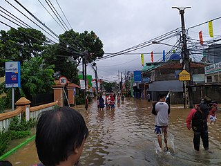
Flash floods occurred throughout the Indonesian capital of Jakarta and its metropolitan area on the early hours of 1 January 2020, due to the overnight rain which dumped nearly 400 millimetres (15 in) of rainwater, causing the Ciliwung and Cisadane rivers to overflow. At least 66 people have been killed, and 60,000 displaced in the worst flooding in the area since 2007.

<span class="mw-page-title-main">Jakarta Bypass</span> Bypass road in Jakarta, Indonesia

The Cililitan-Tanjung Priok Road, also known as the Jakarta Bypass or simply Bypass, is a 27 km long bypass road in Jakarta, Indonesia that connects the Dewi Sartika Road and the Bogor Main Road in Cililitan, East Jakarta to the Port of Tanjung Priok in North Jakarta. The road is divided into four parts: Jalan Mayjen Sutoyo Road, Jalan D.I. Panjaitan, Jalan Jend. Ahmad Yani Road, and Jalan Laksamana Yos Sudarso. The bypass was inaugurated by the first President of Indonesia, Sukarno on October 21, 1963. One of the Jakarta Inner Ring Road sections is built over the road.

References

  1. 1 2 Kali Baru - Geonames.org.
  2. 1 2 3 4 5 6 7 8 9 10 Kali Baru, Proyek Kanal Transportasi yang Gagal - Dian Dewi Purnamasari; Mukhamad Kurniawan/Saiful Rijal Yunus, Kompas.com - 26 September 2016.
  3. BBWS Ciliwung Cisadane. Pengendalian Banjir dan Perbaikan Sungai Ciliwung Cisadane (PBPS CC). Archived in Konservasi DAS Ciliwung - April 2012.
  4. (in Indonesian) Karim, Mulyawan (ed.). Ekspedisi Ciliwung: laporan jurnalistik Kompas : mata air, air mata. Publisher: Penerbit Buku Kompas, 2009. ISBN   9797094243, 9789797094249. 280 pages. Journalistic reportage of an expedition along Ciliwung River, Jawa Barat, Indonesia.
  5. (in Indonesian) Zaenuddin HM “212 Asal-Usul Djakarta Tempo Doeloe,” Penerbit: Ufuk Press October 2012. 377 halaman
  6. (in Indonesian) Inilah Asal usul Nama Kalibaru Jakarta - Nurudin Abdullah & Nurbaiti - 24 December 2014.
  7. 1 2 3 4 (in Indonesian) Gunawan, Restu. Gagalnya sistem kanal: pengendalian banjir Jakarta dari masa ke masa. Penerbit Buku Kompas, 2010. ISBN   9797094839, 9789797094836. 398 pages. p. 158.
  8. Adolf Heuken SJ. Atlas Sejarah Jakarta. Yayasan Cipta Loka Caraka, 2014.
  9. DPUD DKI Jakarta. Potensi Debit Air Baku Pada Wilayah Sungai DKI Jakarta. 2003.
  10. Penyelamatan tanah, air, dan lingkungan. Sitanala Arsyad, Ernan Rustiadi (eds.). Publisher: Yayasan Pustaka Obor Indonesia, 2008. ISBN   9794617024, 9789794617021. 288 pages. p. 98.
  11. Peel, M C; Finlayson, B L; McMahon, T A (2007). "Updated world map of the Köppen-Geiger climate classification". Hydrology and Earth System Sciences. 11 (5): 1633–1644. doi: 10.5194/hess-11-1633-2007 .
  12. "NASA Earth Observations Data Set Index". NASA. 30 January 2016. Archived from the original on 26 April 2020. Retrieved 16 January 2018.
  13. "NASA Earth Observations: Rainfall (1 month - TRMM)". NASA/Tropical Rainfall Monitoring Mission. 30 January 2016. Archived from the original on 9 October 2016. Retrieved 16 January 2018.
  14. Ini 5 Faktor Penyebab Banjir Jakarta, Enggak Cuma dari Cuaca Ekstrem - Silvia Rahmatina Okezone News, 13 December 2017.
  15. 1 2 Penyelam Koarmabar Atasi Penyumbatan Kali Baru Timur Cawang - Puspen TNI - 14 May 2010.

6°06′S106°48′E / 6.10°S 106.80°E / -6.10; 106.80