Map of the district and others. Click for broader map and to enable varied magnification.
Kemayoran is a district (kecamatan) of Central Jakarta, Jakarta in Indonesia. It was best known for the former Kemayoran Airport and it has been transforming as a new central business district.[1] As of 2023, it consists of numerous four and five-star hotels, restaurants, premium office towers, hospitals as well as shopping and entertainment centers. Kemayoran is also home to the Jakarta Fair, the largest and longest fair in Southeast Asia that attracts more than 4 million visitors annually.[2]
Kemayoran is between Jalan M.H. Thamrin, Ancol Dreamland, and the Port of Tanjung Priok. Its proximity between Jakarta's primary central business district, a Southeast Asian tourist hotspot, and one of the busiest ports in the world,[3] has made Kemayoran a prime real estate for many local and foreign investors. Moreover, Kemayoran is 20 20-minute journey from Soekarno-Hatta International Airport.
Kemayoran is serviced by Trans-Java Toll Road, which traverses the island of Java. As of 2022, the government has finished the construction of the Light Rail Transit (LRT) station in Kemayoran with the rest of Jakarta by that means.[4]
Villages
The district of Kemayoran comprises eight urban villages (kelurahan), having the postal/zip/area codes as follows:
Isaac de l'Ostal de Saint-Martin attributed to Jan de Baen, the landlord of several areas in Java, including Kemayoran in what is now Jakarta.
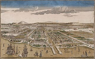
Even though the area that was known as Batavia stretches from Tangerang to Bogor, physical development is still limited to the area near the city center around the Sunda Kelapa harbor area. Limitations of this development is partly due to the condition of Batavia being a walled city with fortifications because of many attacks from local Sultanates to seize Batavia, as well as because of the centralized system of the government. Only in 1810 that the city wall of Batavia was demolished, during the reign of Daendels. Meanwhile, rural areas and suburbs of Batavia are still largely 'untouched' with several native villages. These rural areas were later shared to several landlords, one of which is the area that is now known as Kemayoran.[5]
The area that was known as Kemayoran was formerly land owned by the Dutch East India Company commander, Isaac de l'Ostal de Saint-Martin (ca. 1629–96). At the end of the 17th century, Isaac owned a large area in Java, [citation needed] which includes the area that is now Kemayoran, part of Ancol, Krukut at Tegalangus, and Cinere. Isaac held the title major, which is where the name Kemayoran comes from. The name is Mayoran first appeared in Java Government Gazette on February 24, 1816, described as "a land close to Weltevreden". Later, the area was known as Kemayoran until now.[6]
Until the early 20th century, Kemayoran was still dominated by swamps and paddies with small settlements. Administratively, Kemayoran was a Weekmeester governed by a Bek ("Defender"). After the independence of Indonesia, Kemayoran became part of the Sawah Besardistrict in Penjaringan, Jakarta Raya. From 1963 to 1968, Kemayoran was part of the district of Senen in Jakarta Raya. Ever since 1968, Kemayoran became a district of Central Jakarta.[5]
At first, the inhabitants of Kemayoran were natives from a mixture of several ethnic groups from the local kingdom of Pajajaran, Demak, Mataram, and several foreign nations who arrived as immigrants. After the Dutch occupied, there were immigrants from China, India, Sumatra, and East Indonesia that were used as workers for the expansion and development of Batavia or to participate in military service against Sultan Hasanuddin and Sultan Agung of Mataram.[5]
Under the government of Daendels, to collect funds for the construction of the new Anyer-Panarukan road, some lands were sold to private owners. Generally, the buyers were of Dutch, Chinese, and Arabic origin. Among them were Roosendaal, H. Hussein Madani (Indo-Dutch), Abdullah, and De Groof. These landlords had the power to regulate land from users, who were the indigenous population and serfs. After slavery was abolished, these people became farmers who worked for the landlords, then the landlords would determine the taxes to be paid.[5]
In 1903, Batavia moved to a decentralized form of government, which marked the period of modern colonialism in Batavia. Many lands are repaired, canals are constructed, and the city is expanded. Lands were purchased for the expansion of the city, which included the settlements of Kemayoran, Petojo, Jatibaru, Cideng, Kramat, and Tanah Tinggi. These lands were allocated to lower-middle-class people. More affluent citizens such as the Dutch people and other higher class people live closer to the center, such as in the Menteng residential area.[5]
Many of the people who resided in Kemayoran were Indo people (mixed Dutch and Indonesian). Most of them lived in Jl. Garuda. Even after World War II, many former Dutch soldiers settled in Kemayoran. Around the 1930s, Kemayoran was known as a settlement of the Indo people, giving rise to a new nickname for Kemayoran, "Belanda Kemayoran" (roughly translates to Kemayoran Netherlands). After Indonesian independence, a wave of urban migrants arrived in Kemayoran and Jakarta from various regions in Indonesia such as West Java, Central Java, Sumatra, Kalimantan, East Nusa Tenggara, and West Nusa Tenggara. Because of this, Kemayoran transformed into a more crowded settlement.[5]
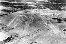
In 1935, Kemayoran Airport was opened. This started to change the economy of Kemayoran from agriculture to service, but many areas of Kemayoran were still sparsely distributed settlements with vacant land. With the opening of the Soekarno-Hatta International Airport and the closure of the Kemayoran Airport, Kemayoran was able to be transformed into the new central business district of Jakarta. Since then, many entertainment centres, hotels, and offices have been built. The government added numerous infrastructure such as the Light rail and Trans-Java Toll Road, to support the rapid growth of the central business district of Kemayoran.
Kota Baru Bandara Kemayoran
In 1986, Kemayoran Airport was officially closed. Under the 2015-2019 National Medium-Term Long-Term Development Plan (RPJMN), the Ministry of Public Works and Public Housing (PUPR) proposed Kemayoran to become an area that had the opportunity to become a new city.[7] The area that was formerly an airport was gradually turned into other developments such as Jakarta International Expo and Kotabaru Bandar Kemayoran (both of these were located in Pademangan District in North Jakarta instead of Kemayoran District in Central Jakarta. Kemayoran Planning and Development Center (PPK) is responsible for the development as well as monitoring of the area.
Kota Baru has an area of 454 hectares. At present, there are several vertical residential designation blocks, office blocks, hospitals, shopping center blocks as well as five and four-star hotels.[8][9] There is also an urban park of 22.3 hectares area which has a lake, a mangrove area, an amphitheater, viewing towers, jogging tracks, and a hanging bridge.[10]
Jakarta International Expo Kemayoran main building is actually located in Pademangan district, but is associated with Kemayoran district due to its location in the former area of the historic Kemayoran city, and its close proximity with Kemayoran.
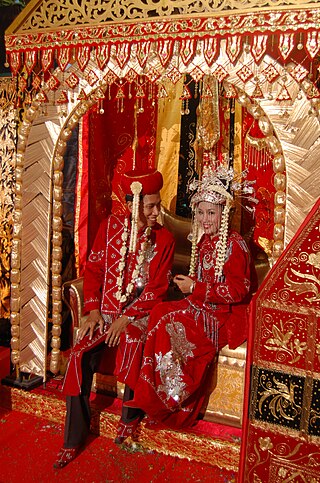
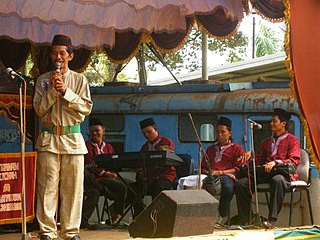
Many indigenous cultures, especially the Betawi culture, flourished in Kemayoran. Among them is the kroncong music, a mixture of indigenous music and Portuguese fado music. Kroncong Tugu, a variation of kroncong that originally came from Tugu (about 12km east of present-day Jakarta), is a variation that is closely associated with Kemayoran. Because of rapid development, Kemayoran has transformed into a modern city itself. Consequently, cultural values such as the Betawi culture are threatened.[5]
Gambang music also developed in Kemayoran under the influence of China. The variation of gambang that developed in Kemayoran is often called Gambang Kemayoran and it is not referred to as Gambang Kromong because the kromong (a kind of percussion) is not used. Songs that were popular at the time included Onde-onde, Si Jongkong Kopyor, and Kapal Karem.
The Wayang Kulit of Kemayoran originates from Javanese influences. The main difference is that the language used is the Betawi language instead of the Javanese language. During the colonial era, Wayang Kulit was usually performed at ceremonies such as wedding ceremonies, circumcision ceremonies, and New Year parties.
One of the popular artists associated with Kemayoran theater is Benyamin Sueb.
Pencak silat, a martial art of the Betawi people, also became popular in Kemayoran. Styles of pencak silat developed in Kemayoran area are Beksi, Cingkrik, Si tembak, Sin lam ba, and Kolong meja. Until the late 80's, it is a common routine for children to practice pencak silat after the Isha prayers.
During the 1990s, much of the traditional art and culture of Betawi characteristic of Kemayoran slowly disappeared.
Folklore
There are many folklores associated with Kemayoran, usually involving the conflict between the indigenous people of Kemayoran and the Dutch kompeni (local term for Dutch East India Company who applied huge taxes to the local people.) One of the popular heroes from the legend is Murtado "Si Macan Kemayoran" ("the Kemayoran Tiger") who protected the Kemayoran village area against the Dutch East India Company henchmen and the local bully who oppressed the villagers.
Jakarta, officially the Special Capital Region of Jakarta and formerly known as Batavia until 1949, is the nation's capital city and the centre of the largest metropolis of Indonesia. Lying on the northwest coast of Java, the world's most populous island, Jakarta is the largest metropole in Southeast Asia, and serves as the diplomatic capital of ASEAN. Jakarta is bordered by two provinces: West Java to the south and east; and Banten to the west. The Special Capital Region has a status equivalent to that of a province. Its coastline faces the Java Sea to the north, and it shares a maritime border with Lampung to the west. Jakarta's metropolitan area is ASEAN's second largest economy after Singapore.
Banten is the westernmost province on the island of Java, Indonesia. Its capital city is Serang and its largest city is Tangerang. The province borders West Java and the Special Capital Region of Jakarta on the east, the Java Sea on the north, the Indian Ocean on the south, and the Sunda Strait on the west and shares a maritime border with Bengkulu and Lampung to the east and Bangka Belitung Islands to the north. The province covers an area of 9,352.77 km2 (3,611.12 sq mi). It had a population of over 11.9 million in the 2020 census, up from about 10.6 million in 2010. The estimated mid-2023 population was 12.308 million. Formerly part of the province of West Java, Banten was split off to become a province on 17 October 2000.
Indonesia is a country with many different tribes and ethnic groups, and its music is also very diverse, coming in hundreds of different forms and styles. Every region has its own culture and art, and as a result traditional music from area to area also uniquely differs from one another. For example, each traditional type of music is often accompanied by its very own dance and theatre. Contemporary music scene have also been heavily shaped by various foreign influences, such as America, Britain, Japan, Korea, and India.
North Jakarta is one of the five administrative cities which form Special Capital Region of Jakarta, Indonesia. North Jakarta is not self-governed and does not have a city council, hence it is not classified as a proper municipality. It contains the entire coastal area within the Jakarta Special Capital Region. North Jakarta, along with South Jakarta is the only two cities in Jakarta to border Banten and West Java. It is also the only city of Jakarta with a coastline and thus not landlocked. North Jakarta, an area at the estuary of Ciliwung river was the main port for the kingdom of Tarumanegara, which later grew to become Jakarta. Many historic sites and artefacts of Jakarta can be found in North Jakarta. Both ports of Tanjung Priok and historic Sunda Kelapa are located in the city. The city, which covers an area of 139.99 km2, had 1,645,659 inhabitants at the 2010 census and 1,778,981 at the 2020 census; the official estimate as at mid 2023 was 1,801,963. It has its administrative centre in Tanjung Priok.
Pencak silat is an umbrella term for a class of related Indonesian martial arts. In neighbouring countries, the term usually refers to professional competitive silat. It is a full-body fighting form incorporating strikes, grappling, and throwing, in addition to weaponry. Every part of the body is used and subject to attack. Pencak silat was practiced not only for physical defense but also for psychological ends. There are hundreds of different pencak silat styles and schools which tend to focus either on strikes, joint manipulation, weaponry, or some combination thereof.
Betawi people, or Batavians, are an Austronesian ethnic group native to the city of Jakarta and its immediate outskirts, as such often described as the native inhabitants of the city. They are the descendants of the people who inhabited Batavia from the 17th century onwards.
Jagakarsa is the southernmost district in the administrative city of South Jakarta, Indonesia. Jagakarsa is bounded by Ciliwung River to the east, Krukut River to the west, and Margasatwa-Sagu-Joe-T.B.Simatupang-Poltangan Road to the north, while the boundary marches with Depok city to the south.
Jakarta is Indonesia's capital and largest city. Located on an estuary of the Ciliwung River, on the northwestern part of Java, the area has long sustained human settlement. Historical evidence from Jakarta dates back to the 4th century CE, when it was a Hindu settlement and port. The city has been sequentially claimed by the Indianized kingdom of Tarumanegara, the Hindu Kingdom of Sunda, the Muslim Sultanate of Banten, and by Dutch, Japanese and Indonesian administrations. The Dutch East Indies built up the area before it was taken during World War II by the Empire of Japan and finally became independent as part of Indonesia.
Kemayoran Airport, also known in its old spelling as Kemajoran, was the principal airport in Jakarta, Indonesia from 1940 until 1985. Kemayoran was built during Dutch East Indies administration by the Department of Transport, Public Works and Irrigation in 1934 on the land that was formerly swamps, rice fields, and residential areas.
The capital of Indonesia, officially the capital of the Unitary State of the Republic of Indonesia, is Jakarta, one of the oldest continuously inhabited cities in Southeast Asia. However, since the enaction of the Special Region of Jakarta Act, Jakarta lost its de jure status as capital of Indonesia, and currently in transitional period to its relocation to Nusantara.
Benteng people are a Chinese Indonesian community of 'Peranakan' or mixed descent, native to the historic Tangerang area in the modern-day Indonesian provinces of Jakarta, Banten and West Java.
The following is a timeline of the history of the city of Jakarta, Indonesia.
Gambang kromong is a traditional orchestra of Betawi people which is a blend of gamelan, Western music and Chinese-style pentatonic base tones. Gambang kromong is closely associated with the Chinese Betawi community, especially the Chinese Peranakan. It was popular in the 1930s.
A kongahyan is an Indonesian musical instrument played by drawing a bow across one or more strings. Kongahyans are similar to the rebab, which can be found in Java, Bali and Sunda Islands. This musical instrument is played for shows on those islands. The kongahyan is smaller than two other Indonesian instruments, the tehyan and sukong.
The following outline is provided as an overview of and topical guide to Jakarta:
Cingkrik Silat is one of the traditional pencak silat styles of the Betawinese. This style originally came from the Rawa Belong area, which is now part of the Kebon Jeruk subdistrict, West Jakarta, Indonesia. This style was created by Ki Maing around the 1920s. Cingkrik Silat has now been spread to various places in Jakarta through many silat schools opened by its practitioners.
Perguruan Silat Mustika Kwitang, or simply called Kwitang silat, is a Betawinese pencak silat style. It was originally developed in the Kwitang village, which is now part of the Senen subdistrict in Central Jakarta, Indonesia. This style is a hybrid martial arts, developed by combining the local silat with the Chinese-influenced kuntao. The Mustika Kwitang Silat School was founded in 1945 by H. Muhammad Djaelani, who previously studied the martial arts from his own family.
Roti gambang or ganjel rel is an Indonesian rectangular-shaped brown bread with sesame seeds, flavoured with cinnamon and palm sugar.
Tanjidor is a traditional Betawi musical ensemble developed in Jakarta, Indonesia. This musical ensemble took the form of a modest orchestra and was developed in the 19th century, pioneered by Augustijn Michiels better known as Major Jantje in the Citrap or Citeureup area on the outskirt of Batavia.
Silat Sabeni Tenabang, often shortened as Sabeni silat, is one of the Betawinese pencak silat styles. The style was created by its eponymous founder Sabeni bin Canam around the end of the 19th century, when Indonesia was still in the Dutch colonial period. It was originally developed in the Tanah Abang district, now part of Central Jakarta, Indonesia.
This page is based on this Wikipedia article Text is available under the CC BY-SA 4.0 license; additional terms may apply. Images, videos and audio are available under their respective licenses.