Gambir | |
|---|---|
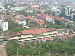 Gambir railway station and Immanuel Church are located in the eastern edge of Gambir. | |
 Interactive map of Gambir | |
| Country | Indonesia |
| Province | Jakarta |
| Administrative city | Central Jakarta |

Gambir is a district (Indonesian : kecamatan ) in the administrative city of Central Jakarta, Indonesia. It is characterized by many historic buildings from the colonial era. It hosts some of the foremost political and learning/tourism features of the capital. The Merdeka Palace (the presidential palace of Indonesia), the National Museum, the headquarters of the Indonesian Scout Movement and the Merdeka Square (in which stands the National Monument) are among these.
Contents
- Limits
- Toponym
- History
- Kelurahan (Administrative Villages)
- List of important places
- References
- Cited works
One of the busiest railway stations, Gambir Station, is in the focal Gambir neighbourhood (an underlying Administrative Village as the translation is usually rendered) of the district. The City Hall of Central Jakarta is in Petojo Selatan here.


