Jatinegara

Last updated

Jatinegara
Stasiun Jatinegara 2020.jpg
Jatinegara Station, gateway to Jatinegara.
Jatinegara
Location in East Jakarta
Coordinates: 6°49′35″S106°10′37″E / 6.82639°S 106.17694°E / -6.82639; 106.17694
Country Indonesia
Province Jakarta
Administrative city East Jakarta
Area
  Total10.64 km2 (4.11 sq mi)
Population
  Total263,706
  Density25,000/km2 (64,000/sq mi)
Postal code
133XX and 134XX

Jatinegara (originally known as Meester Cornelis or Meester for short) is one of the districts (Indonesian : kecamatan) of the administrative city of East Jakarta, Indonesia. The name also refers to the larger, historic area of the colonial town of Meester Cornelis. Established in the 17th century, Jatinegara is one of the oldest areas in Jakarta, and contains a number of buildings from the colonial period.

Contents

The area is historically known for its cosmopolitan character, dominated formerly by indigenous Christians from the so-called Outer Islands, but also with sizeable Chinese and Arab communities (Vreemde Oosterlingen or 'foreign orientals'). [1] Jatinegara railway station, one of the biggest railway stations in Jakarta, is located on the boundary between the districts of Jatinegara and Matraman.

Another Jatinegara, an administrative village in Cakung, has no known historic connection to Jatinegara in Jakarta.

History

Pre-colonial era

The name Jatinegara is derived from Jatina Nagara, Sundanese for "the might of the state", symbolizing the resistance of the princes of Banten in their fight against the Dutch East India Company. Local lore claims that, sometime in the 17th century, Jatinegara became home to a settlement of Bantenese princes and their followers. [2]

Early colonial period

During the Dutch colonial period, the area was renamed Meester Cornelis, after Cornelis Senen. He was one of the most celebrated Malay-speaking (Calvinist) preachers and schoolmasters of his time. He was the son of an indigenous Christian who had been resettled by the Company in Lontor, one of the (Banda Islands). [3] In 1656, Senen was granted a private estate ( particuliere land ) to the east of Ciliwung, with total area of 5 square kilometers, about 12 km southeast of the fort of Batavia. As a landlord (Landheer), he was addressed by the old Dutch honorific Meester or master. The land was harvested for timber and used mainly for agriculture. Cornelis Senen died in 1661, and gave his name to his old estate until it was renamed after Indonesian independence.

The post Meester Cornelis near Ciliwung Post Meester Cornelis Batavia 1744.jpg
The post Meester Cornelis near Ciliwung

During the 18th century, Meester Cornelis was a military district with residential areas, wide roads, and a semi-rural character. A buffalo market, known for its "Thursday Market", was built in the vicinity in 1706. A fort was built in 1734. The commander of the fort established entertainment facilities around the fort, including a playhouse. In 1746, an encampment for soldiers with malaria was built in this area because of its higher altitude and drier air.

An artillery school was established in 1805. In 1810, the Napoleonic Governor-General of the Dutch East Indies, Herman Willem Daendels (1762–1818) designated Meester Cornelis as Batavia's line of defence against a possible, British attack. The defence system was centered on the Meester Cornelis fort. The British attacked in 1811, won and installed a temporary British administration in the Dutch East Indies. In 1820, under the newly restored Dutch government, the fort was transformed into a prison. [4]

Meester Cornelis Military School COLLECTIE TROPENMUSEUM De Militaire School in Meester Cornelis Batavia TMnr 60022681.jpg
Meester Cornelis Military School

Meester Cornelis Military School was opened in 1852 and closed in 1892. While not the first military school in the Dutch East Indies, it was certainly the most successful. One third of the students were born in the colony; the majority came from the Netherlands; and one tenth were other Europeans, mostly from Germany. Most students were from the middle class. The school was later closed down because of financial problems: only one in three students graduated, so the costs per student were unacceptably high.

Modern colonial period

Bird's-eye view of the center of the municipal of Meester Cornelis around its main station. COLLECTIE TROPENMUSEUM Luchtfoto van Meester Cornelis met het S.S. station Batavia TMnr 10014900.jpg
Bird's-eye view of the center of the municipal of Meester Cornelis around its main station.

Beginning in the 19th century, Jatinegara became one of Batavia's key transportation nodes. A horse tram was established in 1869 connecting Meester Cornelis to Kota Intan (the "Diamond City", the oldest Dutch settlement in Jakarta), via Harmoni. On January 31, 1873, the Dutch East Indian Railway Company established a railway line from Meester Cornelis to Buitenzorg (now Bogor). This line converged on the Meester Cornelis Station (now Jatinegara Station), one of the four oldest railway stations in Jakarta. On April 6, 1875, a railway connection between Meester Cornelis and Batavia was inaugurated, thus connecting the old city of Batavia with Buitenzorg. In the 1880s, the Batavian Eastern Railway Company (BOS) also constructed a 35-mile (56 km) route linking Batavia with Karawang via Meester Cornelis and Bekasi.

In 1881, a steam-powered tram was established between Kota Intan and Meester Cornelis through Glodok, Harmoni, Pasar Baru, Pasar Senen and Kramat. On 6 April 1925, electric trains operated for the first time, serving a 15.6 km route from Port Tanjung Priok to Jatinegara and 2.6 km route from Jatinegara to Manggarai. The numerous public transportation lines servicing Meester Cornelis indicated the significance of this area at that time. [2]

Meester was, at first, governed by an Assistant-Resident, overseeing a traditional bureaucracy with separate administrations for the Europeans, 'Foreign Orientals' and indigenous population of the territory. In 1905, Meester Cornelis was chartered as a town with its own council, similar to Batavia; then sometime after 1922, a Mayor replaced the Assistant-Resident. The Mayors were Mr. M. Doorninck (1922–1932) and Mr. G. Pitlo (1933–1935).

Being strategically located, Meester Cornelis also became a center for entertainment and leisure. One of Jakarta's earliest cinemas, the relatively modest Centrale Cinema, was opened in 1912 on what is now Jalan Matraman. The cinema would continue to be called Centrale up until the early 1950s, but then underwent a name change to Djaja Cinema (probably during the Sukarno period). The cinema was demolished sometime in the 1980s. [5]

In 1935, Meester Cornelis was officially transferred to the administration of the government of Batavia.

Japanese occupation and Indonesian independence

Under the Japanese occupation, the name Meester Cornelis was deemed too Dutch, and was changed to Djatinegara. The name has been retained to this day, though older residents, certain transportation routes and one of the local markets still use the old, colonial name 'Meester'.

Subdistricts

Jatinegara is one of the districts of East Jakarta. The boundaries of Jatinegara are Bekasi Barat Raya - Bekasi Timur Raya - Jalan I. Gusti Ngurah Rai to the north, Kali Sunter to the east, Kali Malang canal - Jakarta-Cikampek Tollway to the south, and Ciliwung River to the west.

The district of Jatinegara is divided into eight kelurahan or subdistricts:

NameArea/postal code
Bali Mester13310
Kampung Melayu13320
Bidaracina1330
Cipinang Cempedak13340
Rawa Bunga13350
Cipinang Besar Utara13410
Cipinang Besar Selatan13410
Cipinang Muara13420

List of important places

Saint Joseph's Church in Jatinegara. Gereja Santo Yoseph, Matraman, Jatinegara, Jakarta.jpg
Saint Joseph's Church in Jatinegara.

Notable residents

Other

The Meester-Cornelis (H5) meteorite fell in Jakarta Raya, Indonesia, on 2 June 1915. A total mass of 24.75 kg was recovered.

Related Research Articles

<span class="mw-page-title-main">North Jakarta</span> Administrative city in Jakarta, Indonesia

North Jakarta is one of the five administrative cities which form Special Capital Region of Jakarta, Indonesia. North Jakarta is not self-governed and does not have a city council, hence it is not classified as a proper municipality. It contains the entire coastal area within the Jakarta Special Capital Region. North Jakarta, along with South Jakarta is the only two cities in Jakarta to border Banten and West Java. It is also the only two cities and regencies of Jakarta with a coastline and not landlocked along with the Thousand Islands Regency. North Jakarta, an area at the estuary of Ciliwung river was the main port for the kingdom of Tarumanegara, which later grew to become Jakarta. Many historic sites and artefacts of Jakarta can be found in North Jakarta. Both ports of Tanjung Priok and historic Sunda Kelapa are located in the city. The city, which covers an area of 139.99 km2, had 1,645,659 inhabitants at the 2010 census and 1,778,981 at the 2020 census; the official estimate as at mid 2022 was 1,793,550 - comprising 905,575 males and 887,975 females. It has its administrative centre in Tanjung Priok.

<span class="mw-page-title-main">Gambir, Jakarta</span> District in Central Jakarta, Indonesia

Gambir is a district in the administrative city of Central Jakarta, Indonesia.. It is characterized by many historic buildings from the colonial era. It hosts some of the foremost political and learning/tourism features of the capital. The Merdeka Palace, the National Museum, the headquarters of the Indonesian Scout Movement and the Merdeka Square are among these.

<span class="mw-page-title-main">Jakarta Kota railway station</span> Railway station in Indonesia

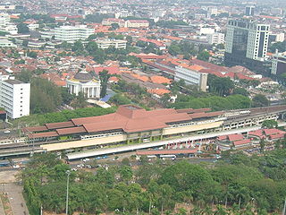
Jakarta Kota Station is a railway station, located in the old city core of Kota, Jakarta, Indonesia.

<span class="mw-page-title-main">Sawah Besar</span> District in Special Capital City District of Jakarta, Indonesia

Sawah Besar is a district (kecamatan) of Central Jakarta, Indonesia. Its neighborhoods are among the most historic, containing the 1820-established Pasar Baru, the new colonial city – Weltevreden – and the old course of the Ciliwung river. Landmarks include the Lapangan Banteng, the government's 19th century-built, low-rise A.A. Maramis Building and its high palmed-lawned vista, and Jakarta Cathedral.

<span class="mw-page-title-main">Senen</span> Subdistrict in Central Jakarta Administrative City, Indonesia

Senen is a long-established urban district of Central Jakarta, Indonesia that has kept many tourist attractions such as two museums, the National Library of Indonesia, Gelanggang Remaja Senen, and narrow alleys with old Chinese and similar style shops and restaurants. It was first developed in the 18th century as Pasar Senen when Governor Daendels established the bovenstad as the new center of government of the fledgling city. Its core remains in what is now the lower-division subdistrict of Senen, Kwitang, Kenari, Paseban, Kramat, and Bungur. Senen is bounded by a railway line to the east, Ciliwung River to the west, Pramuka Street to the south, and Abdul Rahman Saleh-Kwini II-Senen Raya IV Street to the north. The name is derived from Pasar Senen,.

<span class="mw-page-title-main">Ciracas</span> District in DKI Jakarta, Indonesia

Ciracas is a district (kecamatan) of East Jakarta, one of the five administrative cities of Jakarta, Indonesia. Ciracas is the southernmost district in Jakarta. The area of Cibubur Scout's camping ground complex is located partly within the Ciracas District, although the main camping ground area is located in Cipayung District. The boundaries of Ciracas District are: Cipinang River to the west, Cipinang River - Jambore Road to the south, Jagorawi Tollroad to the east, and Kelapa Dua Wetan Road to the north.

<span class="mw-page-title-main">Matraman</span>

Matraman is a district (kecamatan) of East Jakarta, Indonesia. Matraman is the smallest district of East Jakarta. The boundaries of Matraman are: Bekasi Barat Raya Road to the south, Prof Wiyoto Witono MSc Highway to the east, Pramuka Road to the north, and Ciliwung River to the west.

Pasar Rebo is a district (kecamatan) of East Jakarta, Indonesia. The boundaries of Pasar Rebo District are the Ciliwung to the west and north; and Bogor Raya Road and Cipinang River to the east. The city of Depok is located to the south of Pasar Rebo District.

<span class="mw-page-title-main">History of Jakarta</span> Timeline of Jakartas history

Jakarta is Indonesia's capital and largest city. Located on an estuary of the Ciliwung River, on the northwestern part of Java, the area has long sustained human settlement. Historical evidence from Jakarta dates back to the 4th century CE, when it was a Hindu settlement and port. The city has been sequentially claimed by the Indianized kingdom of Tarumanegara, the Hindu Kingdom of Sunda, the Muslim Sultanate of Banten, and by Dutch, Japanese and Indonesian administrations. The Dutch East Indies built up the area before it was taken during World War II by the Empire of Japan and finally became independent as part of Indonesia.

<span class="mw-page-title-main">Jatinegara railway station</span> Railway station in Indonesia

Jatinegara Station (JNG) is a large type A-class railway station located on the border between Jatinegara and Matraman in Pisangan Baru Subdistrict, Matraman, East Jakarta. The station is the main entrance to Jakarta from cities east of Jakarta. Jatinegara station is operated by Kereta Api Indonesia and KAI Commuter.

<span class="mw-page-title-main">Pasar Baru</span> Subdistrict in Jakarta, Indonesia

Pasar Baru is an subdistrict in the Sawah Besar district in Central Jakarta, Indonesia. It has postal code of 10710.

Kwitang is an administrative village (kelurahan) in the subdistrict (kecamatan) of Senen, Central Jakarta. It is one of the historic administrative village of Jakarta. The boundary of Kwitang is the Ciliwung to the west, Jalan Kramat Kwitang to the north, Jalan Kramat Raya to the east, and Jalan Kramat 4 to the south.

<span class="mw-page-title-main">Bekasi railway station</span> Railway station in Indonesia

Bekasi Station (BKS) is a railway station located in Marga Mulya, North Bekasi, Bekasi, West Java. The station is at an altitude of +19 meters above sea level. This station serves the KRL Commuterline and inter-city trains.

<span class="mw-page-title-main">Manggarai railway station</span> Railway station in Indonesia

Manggarai Station (MRI) is a railway station at Manggarai, Tebet, South Jakarta, Jakarta, Indonesia. At present, it serves primarily as a transit station for KRL Commuterline's Bogor Line, Cikarang Loop Line, and Soekarno–Hatta Airport Rail Link; The Bukit Duri depot is located at the south side of the station, it also serves as a storage for intercity trains before they go to Gambir or Jakarta Kota stations for their departure.

<span class="mw-page-title-main">KAI Commuter Cikarang Loop Line</span> Commuter rail line in Indonesia

The Cikarang Loop Line, officially the Cikarang Commuter Line, is a commuter rail line in Jakarta, Indonesia which is operated by PT Kereta Commuter Indonesia (KCI). The line connects Kampung Bandan station in North Jakarta and Cikarang station in Cikarang, Bekasi Regency, West Java. On maps and diagrams, the line is shown using the color "blue". Jakarta Kota–Cikarang is the extension of previously Jakarta Kota–Bekasi line which connects to Cikarang since 8 October 2017.

<span class="mw-page-title-main">Jalan Gajah Mada and Jalan Hayam Wuruk</span>

Jalan Gajah Mada and Jalan Hayam Wuruk, formerly Molenvliet West and Molenvliet Oost respectively, is a major thoroughfare located in Jakarta, Indonesia. The two streets with its canal, the Batang Hari, connect Glodok and Kota Tua Jakarta to the north with Harmoni Junction to the south. Completed in late 1640s, the canal-street Gajah Mada and Hayam Wuruk is Jakarta's oldest major thoroughfare.

<span class="mw-page-title-main">Baru Timur River</span> River in Jakarta, Indonesia

Baru Timur River is a man-made canal flowing from Ci Liwung in Bogor Regency to Jakarta, Indonesia. It was one of two canals built in the 18th century under the order of Governor-General Gustaaf Willem van Imhoff originally to transport agricultural harvest from Bogor to Batavia. Currently, both canals, now known as Kali Baru Timur and Kali Baru Barat, are among the main rivers in Jakarta, and part of the Ciliwung Cisadane flood control project. Baru Timur River flows from the Katulampa flood gate, built at the same time as the canal, along the major road Bogor Highway, passing Cimanggis, Depok, Cilangkap, until reaching the Java Sea in Kali Besar, Tanjung Priok, North Jakarta.

Lauw Tek Lok, Luitenant der Chinezen was a high-ranking government official and landlord in Batavia, Dutch East Indies, and a member of the Lauw-Sim-Zecha family, part of Java’s Cabang Atas gentry. He is remembered today for his long tenure as Luitenant der Chinezen of Bekasi, and for his interracial marriage with Louisa Zecha.

<span class="mw-page-title-main">Transjakarta Corridor 5</span> Bus rapid transit route in Indonesia

The TransJakarta Corridor 5 is a bus rapid transit corridor in Jakarta, Indonesia, operated by TransJakarta. The corridor connects Ancol, North Jakarta with the Kampung Melayu Bus Terminal in Jatinegara, East Jakarta. The roads that passed by corridor 5 are Jalan Gunung Sahari, Jalan Pasar Senen, Jalan Kramat Raya, Jalan Salemba Raya, Jalan Matraman Raya, Jalan Jatinegara Barat/Timur and arrive at Kampung Melayu Terminal. From Pademangan to Pasar Jatinegara BRT stations, several stations are close to KRL Commuterline stations.

References

  1. Cribb, Robert (2008). Gangsters and Revolutionaries: The Jakarta People's Militia and the Indonesian Revolution, 1945-1949. Singapore: Equinox Publishing. ISBN   9789793780719 . Retrieved 8 November 2017.
  2. 1 2 W. Poerbo, Heru. Rejuvenating Meester Cornelis (PDF). Retrieved 2 May 2010.
  3. Mahdi 2007, p. 101.
  4. 1 2 3 4 5 http://jakartapedia.bpadjakarta.net/index.php/Kecamatan_Jatinegara Kecamatan Jatinegara
  5. Merrillees 2015, p. 88.

Cited works