West Jakarta Jakarta Barat | |
|---|---|
| Administrative City of West Jakarta Kota Administrasi Jakarta Barat | |
| Other transcription(s) | |
| • Betawi | Jakarte Belah Kulon |
 Seal | |
| Motto(s): Kampung Kite Kalo Bukan Kite Nyang Ngurusin Siape Lagi (Betawi) "Our homeland, if it isn't us who maintain it, who else?" | |
 | |
| Country | |
| Special Capital Region | |
| Government | |
| • Mayor | Uus Kuswanto |
| • Deputy Mayor | Hendra Hidayat |
| Area | |
• Total | 129.54 km2 (50.02 sq mi) |
| Population (mid 2023 estimate) [1] | |
• Total | 2,611,515 |
| • Density | 20,000/km2 (52,000/sq mi) |
| Time zone | UTC+7 (WIB) |
| HDI (2024) | |
| Website | barat.jakarta.go.id |
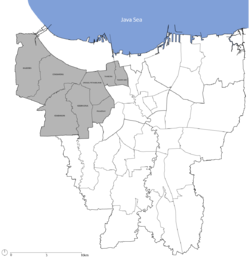
West Jakarta (Indonesian : Jakarta Barat; Betawi : Jakarte Bekulon), abbreviated as Jakbar, is one of the five administrative cities of the Special Capital Region of Jakarta, Indonesia. West Jakarta is not self-governed and does not have a city council, hence it is not classified as a proper municipality. It had a population of 2,281,945 at the 2010 Census [2] and 2,434,511 at the 2020 Census; [3] the official estimate as at mid 2023 was 2,611,515 (comprising 1,312,120 males and 1,299,395 females). [1] The administrative center of West Jakarta is at Puri Kembangan.
Contents
- History
- Administrative Districts
- Economy
- Education
- School system
- Colleges and universities
- Tourism
- Museums
- Temple
- Shopping malls
- Gallery
- Transport
- References
- External links
West Jakarta is bordered by Tangerang Regency and North Jakarta to the north, Central Jakarta to the east, South Jakarta to the south, and Tangerang city to the west.