Cilincing

Last updated
Cilincing
Kecamatan Cilincing
Rumah Pitung.jpg
Rumah si Pitung, a historical house in Cilincing.
Country Indonesia
Province Special Capital City District of Jakarta
City North Jakarta
Area
  Total37.70 km2 (14.56 sq mi)
Population
 (mid 2023)
  Total440,640
  Density12,000/km2 (30,000/sq mi)
Postal code
141XX

Cilincing is a historic neighborhood and administrative district (kecamatan) on the coast of North Jakarta Administrative City, Indonesia. It is sandwiched between the Port of Tanjung Priok to the west and River Titram to the east. Cilincing has been for some decades one of the districts of North Jakarta which in turn encompasses as far as Marunda and some non-coastal hinterland.

Contents

The name Cilincing is likely derived from the name of the river Ci Lincing, the local river that flows to its northern mouth. Ci is a Sundanese word for "river", while Lincing is the name for the plant carambola. [1] [2]

Government

As a district (Indonesian: kecamatan), it is much larger than the historic guise, and includes the coastal neighborhood of Marunda and the more inland neighborhood of Tugu. Cilincing District is the most northeastern district of Jakarta. Much of it is allotted for agriculture and industry. The Cakung Drain, part of Jakarta's flood canal, flows through the district into Jakarta Bay.

Cilincing District is divided into seven Administrative Villages ( kelurahan ):

NameArea/postal code
Kali Baru14110
Cilincing14120
Semper Barat14130
Semper Timur
Sukapura14140
Rorotan
Marunda14150

History

Early development

During the early colonial period, Cilincing (older spelling Tji Lintjing) was a name of a coastal area located around 7 km east of the cape of Priok (Malay Tanjong Priok). The land of Cilincing were dotted with fish ponds, similar with Ancol but less marshy, allowing early settlements to grow. The coast of Cilincing contained a shell-rich beach and among few places in Java which contains the species of cemara laut ("sea pine"). [3]

In late 18th-century, four manor houses (landhuizen) were established by the Dutch, from west to east: Tanjong Priok house belonging to De heer van Riemsdyk, [4] Pajonkoran house (also Jonkoraan) to Richold ter Schegget, [4] Bangliauw house (variously written as Bangleu or Bank Loeau) to Paul Bergman, and the easternmost and the most imposing of all Cilincing mansion belonging to Johannes Christoffel Schultz. [5] These mansions were connected to the walled city of Batavia through the Vaart canal (possibly a pre-Dutch canal) and then to Ancol canal, which was then connected to the outer canal of the walled city of Batavia. [6]

The Cilincing mansion, located roughly in what is now the kecamatan office of Cilincing District, was the administration center of the early settlements in Cilincing. A Tuesday market was established to the north of Cilincing mansion. The mansion was strategically located, being the point where the traffic from the Vaart canal connects with the road to the plantation area to the south. One of the settlement of the southern plantation is the Portuguese Tugu settlement, among the oldest settlement in Jakarta. [7]

Seaside resorts of Cilincing (19th-century – 1970s)

Palm Beach Cilincing in the 1940s, a popular beach area in Cilincing. The beach no longer exist. COLLECTIE TROPENMUSEUM Militairen op Palm Beach bij Tjilintjing TMnr 10028576.jpg
Palm Beach Cilincing in the 1940s, a popular beach area in Cilincing. The beach no longer exist.

Beginning in the late 19th-century, the seaside area of Cilincing started to become a popular seaside recreation area. Dutch people and natives alike flocked to the seaside of Cilincing to enjoy the pristine water or to have a picnic. [8] One popular resort was the Palm Beach Cilincing which was supported with recreational facilities such as eating places and bathing areas.

The popularity of Cilincing as a seaside resort continued to the 20th-century. Another popular seaside resort of Cilincing in the 1950s was the Sindang Laut on the western edge of Cilincing near the Port of Tanjung Priok. Sindang Laut was equipped with restaurant, playground, and berths for small boats. Sindang Laut has been demolished, the area converted into industrial port area, and is now Bogasari Flour Mills. [9]

Industrial and slum area (post 1980s)

Cilincing and its surrounding area continued its popularity as seaside resort until the 1970s. The beginning of the 1980s saw the decline of Cilincing's popularity, mainly caused by the expansion of the Port of Tanjung Priok plus increasing pollution along the north coast of Java. [8] The success of the reclamation of the seaside part of Ancol into Ancol Dreamland resort in 1962 prompted President Suharto to start another reclamation project, the Pantai Mutiara and the Pantai Indah Kapuk project; the land fill for Pantai Indah Kapuk project was dredged from Palm Beach Cilincing. With the shift of Jakarta's seaside resort toward Ancol, Pantai Indah Kapuk, and Pantai Mutiara, Cilincing as seaside resort effectively ended. [10]

By the late 1990s, Cilincing had become industrialized and had become a garbage-strewn slum. [9] What used to be the attractive Palm Beach Cilincing is now an unattractive ship scrapyard, surrounded with slum. The area remain underdeveloped to present time.

Marunda Dam

Based on DKI Jakarta Governor Rule Number 77 Year 2009, 56 hectares of Marunda Dam will be built plus 12 hectares of Integrated Waste Management, 5.8 hectares of Asphalt Mixing Plant, 43.3 hectares of Public Green Designation and 29.9 hectares of Facilities and Infrastructure for Supporting Operational Functions of the East Flood Canal (Kanal Banjir Timur) or totally 147 hectares project. Marunda Dam will be initially built in 2012. [11]

List of important places

Below are list of important places in the district of Cilincing.

See also

Related Research Articles

<span class="mw-page-title-main">Jakarta</span> Capital and largest city of Indonesia

Jakarta, officially the Special Capital Region of Jakarta and formerly known as Batavia until 1949, is the nation's capital city and the centre of the largest metropolis of Indonesia. Lying on the northwest coast of Java, the world's most populous island, Jakarta is the largest metropole in Southeast Asia, and serves as the diplomatic capital of ASEAN. Jakarta is bordered by two provinces: West Java to the south and east; and Banten to the west. The Special Capital Region has a status equivalent to that of a province. Its coastline faces the Java Sea to the north, and it shares a maritime border with Lampung to the west. Jakarta's metropolitan area is ASEAN's second largest economy after Singapore.

<span class="mw-page-title-main">Rebana</span> Musical instrument commonly found in Malay archipelago

The rebana or terbangan is a tambourine that is used in Islamic devotional music in Southeast Asia, particularly in Indonesia, Malaysia, Brunei, and Singapore. The sound of the rebana often accompany Islamic ritual such as the zikir. The name rebana came from the Arabic word robbana. The rebana is also used by the Cham people of Cambodia and also gave rise to the Rabana which is used by the Sinhalese people of Sri Lanka.

<span class="mw-page-title-main">North Jakarta</span> Administrative city in Jakarta, Indonesia

North Jakarta is one of the five administrative cities which form Special Capital Region of Jakarta, Indonesia. North Jakarta is not self-governed and does not have a city council, hence it is not classified as a proper municipality. It contains the entire coastal area within the Jakarta Special Capital Region. North Jakarta, along with South Jakarta is the only two cities in Jakarta to border Banten and West Java. It is also the only city of Jakarta with a coastline and thus not landlocked. North Jakarta, an area at the estuary of Ciliwung river was the main port for the kingdom of Tarumanegara, which later grew to become Jakarta. Many historic sites and artefacts of Jakarta can be found in North Jakarta. Both ports of Tanjung Priok and historic Sunda Kelapa are located in the city. The city, which covers an area of 139.99 km2, had 1,645,659 inhabitants at the 2010 census and 1,778,981 at the 2020 census; the official estimate as at mid 2023 was 1,801,963. It has its administrative centre in Tanjung Priok.

<span class="mw-page-title-main">Betawi people</span> Ethnic group in Indonesia

Betawi people, or Batavians, are an Austronesian ethnic group native to the city of Jakarta and its immediate outskirts, as such often described as the native inhabitants of the city. They are the descendants of the people who inhabited Batavia from the 17th century onwards.

<span class="mw-page-title-main">Gambir railway station</span> Railway station in Indonesia

Gambir Station is a major railway station in Gambir, Gambir, Central Jakarta, Jakarta, Indonesia. The station is located on the eastern side of Merdeka Square and the western side of the Pramuka Movement headquarters and Immanuel Church. It is operated by the KAI.

<span class="mw-page-title-main">Ciracas</span> District in DKI Jakarta, Indonesia

Ciracas is a district (kecamatan) of East Jakarta, one of the five administrative cities of Jakarta, Indonesia. Ciracas is the southernmost district in Jakarta. The area of Cibubur Scout's camping ground complex is located partly within the Ciracas District, although the main camping ground area is located in Cipayung District. The boundaries of Ciracas District are: Cipinang River to the west, Cipinang River - Jambore Road to the south, Jagorawi Tollroad to the east, and Kelapa Dua Wetan Road to the north.

<span class="mw-page-title-main">Sukabumi Regency</span> Regency of Indonesia

Sukabumi Regency is a regency (kabupaten) in southwestern Java, as part of West Java province of Indonesia. The regency seat is located in Palabuhan Ratu, a coastal district facing the Indian Ocean. The regency fully encircles the administratively separated city of Sukabumi. Covering an area of 4,164.15 km2, the regency is the largest regency in West Java and the second largest regency on Java after the Banyuwangi Regency in East Java. The regency had a population of 2,341,409 at the 2010 census and 2,725,450 at the 2020 census; the official estimate as at mid 2023 was 2,802,404, with a large proportion of it living in the northeastern part of the regency that encircles Sukabumi City, south of Mount Gede. A plan to create a new regency, the putative North Sukabumi Regency, is currently waiting for the approval of the central government, which has been deferred until the end of the current morotorium on new creations of regencies.

<span class="mw-page-title-main">Persitara North Jakarta</span> Indonesian football club

Persatuan Sepakbola Indonesia Jakarta Utara is an Indonesian football club based in North Jakarta, Jakarta. This club plays in the Liga 3. The club's home base are the Tugu Stadium.

<span class="mw-page-title-main">Pademangan</span>

Pademangan is a port-associated district (kecamatan) of North Jakarta Administrative City, Indonesia. It stretches from the Sunda Kelapa Harbour in the west to the western area of Tanjung Priok Harbor in the east. Geographically, it is a plain with an average height of 75 centimeters above the high tide sea level.

<span class="mw-page-title-main">Kota Tua Jakarta</span> Historic downtown of northwest Jakarta, Indonesia

Kota Tua Jakarta, officially known as Kota Tua, is a neighborhood comprising the original downtown area of Jakarta, Indonesia. It is also known as Oud Batavia, Benedenstad, or Kota Lama.

<span class="mw-page-title-main">History of Jakarta</span> Timeline of Jakartas history

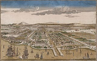
Jakarta is Indonesia's capital and largest city. Located on an estuary of the Ciliwung River, on the northwestern part of Java, the area has long sustained human settlement. Historical evidence from Jakarta dates back to the 4th century CE, when it was a Hindu settlement and port. The city has been sequentially claimed by the Indianized kingdom of Tarumanegara, the Hindu Kingdom of Sunda, the Muslim Sultanate of Banten, and by Dutch, Japanese and Indonesian administrations. The Dutch East Indies built up the area before it was taken during World War II by the Empire of Japan and finally became independent as part of Indonesia.

<span class="mw-page-title-main">Ancol</span> Administrative village in Special Capital City District of Jakarta, Indonesia

Ancol is a coastal lowland area located to the east of Kota Tua Jakarta in northern Jakarta, in Indonesia. The coastal lowland stretched from Kota Tua Jakarta to the west and Tanjung Priok to the east. Today, Ancol contains the main beach resort of Jakarta. Taman Impian Jaya Ancol, the largest integrated tourism area in Southeast Asia, is located in Ancol.

<span class="mw-page-title-main">Colonial architecture in Jakarta</span>

Colonial buildings and structures in Jakarta include those that were constructed during the Dutch colonial period of Indonesia. The period succeeded the earlier period when Jakarta, governed by the Sultanate of Banten, were completely eradicated and replaced with a walled city of Batavia. The dominant styles of the colonial period can be divided into three periods: the Dutch Golden Age, the transitional style period, and Dutch modernism. Dutch colonial architecture in Jakarta is apparent in buildings such as houses or villas, churches, civic buildings, and offices, mostly concentrated in the administrative city of Central Jakarta and West Jakarta.

Si Pitung was a 19th-century bandit in Batavia, Dutch East Indies. His exploits have since become legendary, with numerous accounts of his life, deeds, and death.

<span class="mw-page-title-main">Pasar Baru</span> Subdistrict in Jakarta, Indonesia

Pasar Baru is an subdistrict in the Sawah Besar district in Central Jakarta, Indonesia. It has postal code of 10710.

Kapuk is a subdistrict in the Cengkareng district of Indonesia. An industrial area, Kapuk is nonetheless also home to part of Pantai Indah Kapuk, one of Jakarta's most prestigious suburbs.

Nawi Ismail was an Indonesian film director and actor. He often worked with Dicky Zulkarnaen and Benyamin Sueb.

<span class="mw-page-title-main">Pantai Indah Kapuk</span> Gated community in Jakarta, Indonesia

Pantai Indah Kapuk (PIK) is an integrated township, located in parts of Penjaringan, North Jakarta and Kapuk, West Jakarta, Indonesia. It is one of the most prestigious residential areas in Jakarta along with Menteng, Pondok Indah, and Puri Indah.

<span class="mw-page-title-main">Thousand Islands (Indonesia)</span> Administrative regency in Jakarta, Indonesia

The Thousand Islands are a chain of islands to the north of Jakarta's coast. It forms the only regency of Special Capital Region of Jakarta, the metropolitan province of Indonesia. It consists of a string of 342 islands stretching 45 km (28 mi) north into the Java Sea at West Jakarta Bay and in fact are located to the north of Banten Province. Pramuka Island is the regency seat. The islands, along with North Jakarta City, are the only administrative divisions of Jakarta Special Capital Region with a coastline.

References

  1. Fillet 1883 :292
  2. "Asal Usul Nama Tempat Di Jakarta". Archived from the original on 2009-02-23.
  3. Backer 2012, p. 91.
  4. 1 2 van Geemen 1792, p. 27.
  5. van Geemen 1792, p. 28.
  6. Top. Bureau, Kaart van Batavia en Omstreken 1897.
  7. van Geemen 1792, p. 29.
  8. 1 2 Merrillees 2015, p. 92.
  9. 1 2 Merrillees 2015, p. 93.
  10. Proyek Reklamasi Jakarta: Impian Soekarno dan Soeharto?
  11. "Proyek Waduk Marunda Bakal Gusur Ratusan Keluarga". October 22, 2011.
  12. "Masjid Al-Alam Cilincing". Dinas Pariwisata Dan kebudayaan Provinsi DKI Jakarta (in Indonesian). www.jakarta.go.id. Archived from the original on October 8, 2010. Retrieved April 13, 2010.
  13. "Masjid Aulia Marunda". Dinas Pariwisata Dan kebudayaan Provinsi DKI Jakarta (in Indonesian). www.jakarta.go.id. Archived from the original on May 15, 2011. Retrieved April 13, 2010.
  14. "Makam Kapitan Tete Jonker". Dinas Pariwisata Dan kebudayaan Provinsi DKI Jakarta (in Indonesian). www.jakarta.go.id. Archived from the original on October 9, 2010. Retrieved April 13, 2010.
  15. "Langgar Tinggi / Rumah si Pitung". Dinas Pariwisata Dan kebudayaan Provinsi DKI Jakarta (in Indonesian). www.jakarta.go.id. Archived from the original on July 12, 2010. Retrieved April 13, 2010.
  16. "Poskota.co.id".
  17. Elitha Tarigan (January 9, 2014). "Jokowi Blusukan ke Hutan Kota Rawa Malang". Archived from the original on January 9, 2014. Retrieved January 9, 2014.

Cited works

6°08′S106°57′E / 6.133°S 106.950°E / -6.133; 106.950