Sawah Besar

Last updated • 7 min readFrom Wikipedia, The Free Encyclopedia
Sawah Besar
Pasar Baru Jakarta Pusat.JPG
Pasar Baru, located in the district of Sawah Besar
Country Indonesia
Province Special Capital City District of Jakarta
City Central Jakarta
Postal code
107XX

Sawah Besar is a district (kecamatan) of Central Jakarta, Indonesia. Its neighborhoods are among the most historic, containing the 1820-established Pasar Baru ("New Market"), the new colonial city Weltevreden and the old course of the Ciliwung River. Landmarks include the Lapangan Banteng (formerly Waterloo Square), the government's 19th century, low-rise A.A. Maramis Building and its high palmed-lawned vista (being the intended palace of Daendels), and Jakarta Cathedral.

Contents

Jakarta pusat.png
Jakarta pusat.png
Map of the district and others. Click for broader map and to enable varied magnification.

Toponym

A relatively green kampung area in the vicinity of Sawah Besar stop. Once a paddy field (Indonesian sawah besar), the area gave its name to the street (now Jalan Sukarjo Wiryopranoto), the railway stop, and eventually the district of Sawah Besar. COLLECTIE TROPENMUSEUM Grazende geiten of schapen in de omgeving van de spoorhalte Sawah Besar Batavia TMnr 60009282.jpg
A relatively green kampung area in the vicinity of Sawah Besar stop. Once a paddy field (Indonesian sawah besar), the area gave its name to the street (now Jalan Sukarjo Wiryopranoto), the railway stop, and eventually the district of Sawah Besar.

Sawah Besar means "big paddy field". The name Sawah Besar refers to the paddy field which existed in the area before the 1860s. This paddy field, measuring around 450 square metres (4,800 sq ft), was to the east of the southern section of Molenvliet Oost (now Jalan Hayam Wuruk), south of Kebon Jeruk ("orange orchard") and west of the extensive Chinese cemetery (now Kelurahan Karang Anyar). [1] Before the 1860s, the paddy field was the only one left in the city center of Batavia. Gradually, the paddy field was urbanized and in the late 19th-century, the entire field had been converted into a kampung known as Kampung Sawah Besar. [1]

The name Sawah Besar, also spelled as Sawah Besaar during colonial time, was given to the street Sawah Besar, south of what used to be the paddy field. Sawah Besar Street also formed the northern section of the defensive line of the new southern colonial administrative center of Batavia, the Weltevreden. In the late 19th-century, a new railway stop was established at the east end of the street; the name Sawah Besaar was given to the railway stop, which later would become Sawah Besar railway station. The Sawah Besar street was nationalized as Jalan Sukarjo Wiryopranoto in the 1950s, but the Station still preserved its original name. Eventually, the name Sawah Besar was given to the District (kecamatan) Sawah Besar following the independence of Indonesia.

The street Sawah Besar (Jalan Sukarjo Wiryopranoto) and the original district/marsh were slightly west. Sawah Besar railway station is on today's western limit.

Government

The district is divided into five kelurahan or administrative villages:

NameArea code
Pasar Baru 10710
Gunung Sahari Utara 10720
Mangga Dua Selatan 10730
Karang Anyar 10740
Kartini 10750

History

The section describes the history of the region of Jakarta which corresponds to what is now the modern district (kecamatan) of Sawah Besar.

Draining of the marshes

Fort Jacatra, in the shape of a simple earthen bank fortification, existed in the area at what is now the kampung of Gang Budi Rahayu. 17Het-fort-Jacatra-buiten-Batavia-in-1709.jpg
Fort Jacatra, in the shape of a simple earthen bank fortification, existed in the area at what is now the kampung of Gang Budi Rahayu.

In the 17th-century, the district of Sawah Besar corresponded to the area where the Ciliwung used to flow. The riparian zone was located southeast of Batavia, outside the city wall, then known collectively as the ommelanden (the area surrounding Batavia). To establish a military presence over the new colonial land, the Dutch East India Company built several fortresses to guard the Ciliwung, among them the sconce Jacarta, established in mid-17th-century as the second fortress upstream of Ciliwung after Batavia Castle. [2] The fort had ceased to exist by 1825. The simple fort was located at what is now the kampung of Gang Budi Rahayu.

Ciliwung's riparian zone in the area was characterized by unproductive marshland. To convert the marshes into arable land, canals were constructed to drain the water of the marshes into the river. By the late 17th-century, the marshland had been converted into mills, sugar plantations, fruit trees plantation and paddy field.

In 1681, the flow of Ciliwung was diverted toward the east along the Postweg (now Jalan Pos) to reach another new canal, the Gunung Sahari Canal. With the diversion of the Ciliwung toward the Gunung Sahari Canal, a section of the Ciliwung between Prinsen Laan (now Jalan Mangga Besar) and Postweg (now Jalan Pos) was dried out. [3] The old course of the Ciliwung now corresponds with Jalan Kartini XIII Dalam.

The Chinese Cemetery

In the early 19th-century, a Chinese cemetery (Chineesche Kerkhof) was established around the area of the old course of the Ciliwung. When it was established, the Chinese cemetery was the largest cemetery in Batavia, the total area reached 960 square metres (10,300 sq ft) in 1853. [1] The boundary of the cemetery was the Prinsenlaan (now Jalan Mangga Besar) to the north, Kartiniweg (Jalan Kartini Raya) to the east, Chineesche Kerkweg (Jalan Raya Lautze) to the south, and Drossaersweg (Jalan Taman Sari Raya) to the west. [1] The center of religious activity for the Chinese cemetery was an 18th-century Chinese temple located at Chineesche Kerkweg, in the southern area of the cemetery, which was originally a landhuis belonging to Frederick Coyett. [1] Today the Chinese temple, Vihara Buddhayana or Thie Cang Wang Pho Sat (Klenteng Sentiong), still exists.

By 1825, kampung development started to encroach into the Chinese cemetery. The encroachment started from the west of Kartiniweg. Following the establishment of Pasar Baru in the late 19th-century, urbanization started to encroach the cemetery land from the south, starting with the development of houses north of Pintu Besi street (now Jalan K.H. Samanhudi). The developed kampung was then known as Kampung Karang Anjar, which later gave its name to kelurahan Karang Anyar. [1] Eventually, by the 1930s, the remaining cemetery area was reserved for future city-building projects by the colonial government. Following the independence of Indonesia, the first streets were built from Jalan Raya Mangga Besar into the Chinese cemetery in the early 1970s. Eventually, by the end of the 1970s, the area that used to be the largest Chinese Cemetery in Jakarta was completely converted into an urbanized area.

Today, the entire kelurahan Karang Anyar and the western half of kelurahan Kartini stands on what used to be the largest cemetery in Jakarta.

Weltevreden

The Waterlooplein, the center of the colonial government, located in Weltevreden. COLLECTIE TROPENMUSEUM Militaire parade bij het standbeeld van Jan Pietersz. Coen op het Waterlooplein in Batavia tijdens de kroningsfeesten van Koningin Wilhelmina TMnr 60048906.jpg
The Waterlooplein, the center of the colonial government, located in Weltevreden.

In 1787, the extensive private estate of Weltevreden (Dutch "well-contented") was established in what is now the southern half of the kelurahan Pasar Baru. Weltevreden estate was bounded by the streets Postweg (now Jalan Pos) - Schoolweg Noord (Jalan Dr. Sutomo) to the north; Jalan Gunung Sahari and Jalan Pasar Senen to the east; Jalan Prapatan to the south; and the Ciliwung to the west. In 1808, Weltevreden estate was sold to the government. The area was designated as a new colonial administrative center of Batavia, replacing the dilapidated Oud Batavia near the port of Sunda Kelapa. The open field Waterlooplein (now Lapangan Banteng) was established as the center of the new colonial center. Surrounding this open field was European-centric colonial landmarks built throughout the course of the late 18th and early 19th-centuries. Among the landmarks were the grand residence of the governor-general of Batavia de Witte Huis ("White House") of the Dutch East Indies; the Roman Catholic cathedral, and Fort Prins Frederik. [4]

Weltevreden was also known as bovenstad (Dutch "uptown"), to distinguish it with the benedenstad (the Old Town). The distinction was formalized by the Batavia City Council in 1905; when Batavia and Weltevreden were the two districts which formed the municipality of Batavia. [4]

Today, the area of Weltevreden corresponds to the southern half of the kelurahan Pasar Baru, south of the canal. The area today is still of considerable value given its relative proximity to Central Jakarta. Many colonial and modern landmarks of Jakarta are located in this area, e.g. Hotel Borobudur, the old and new buildings of the Ministry of Finance, Lapangan Banteng, the Roman Catholic Cathedral, Gedung Kesenian, the Pasar Senen market, the Gatot Soebroto Army Hospital and the central post office. [4]

Following the independence of Indonesia, the area where the colonial government once centered were taken over by the Indonesian government as the administrative center of the newly independent country. Some of the political landmark in the area were Lapangan Banteng (converted from the military center Waterlooplein), Hotel Borobudur (converted from a Dutch military encampment), and Istiqlal Mosque converted from Fort Prins Frederik). Many colonial buildings in the area are preserved and can still be seen today as governmental institutions.

List of important places

Below are lists of important places in Sawah Besar district.

Related Research Articles

<span class="mw-page-title-main">Gambir, Jakarta</span> District in Central Jakarta, Indonesia

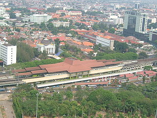
Gambir is a district in the administrative city of Central Jakarta, Indonesia.. It is characterized by many historic buildings from the colonial era. It hosts some of the foremost political and learning/tourism features of the capital. The Merdeka Palace, the National Museum, the headquarters of the Indonesian Scout Movement and the Merdeka Square are among these.

<span class="mw-page-title-main">Pasar Minggu</span> District in Jakarta, Indonesia

Pasar Minggu is a district in the administrative city of South Jakarta, Indonesia. The area is known for its traditional Sunday market, famous for the fruit market. Historically, Pasar Minggu is a fruit cultivation area developed by the Dutch government during the colonial period. The central point of the cultivation area is the traditional market of Pasar Minggu, located in what is now the lower-division Pasar Minggu subdistrict. Teak forest could also be found in the Pasar Minggu district, notably around the Jati Padang subdistrict. Most of these areas have been converted into residential areas as Jakarta grows southward.

<span class="mw-page-title-main">Kemayoran</span> District in Special Capital City District of Jakarta, Indonesia

Kemayoran is a district (kecamatan) of Central Jakarta, Jakarta in Indonesia. It was best known for the former Kemayoran Airport and it has been transforming as a new central business district. As of 2023, it consists of numerous four and five-star hotels, restaurants, premium office towers, hospitals as well as shopping and entertainment centers. Kemayoran is also home to the Jakarta Fair, the largest and longest fair in Southeast Asia that attracts more than 4 million visitors annually.

<span class="mw-page-title-main">Senen</span> Subdistrict in Central Jakarta Administrative City, Indonesia

Senen is a long-established urban district of Central Jakarta, Indonesia that has kept many tourist attractions such as two museums, the National Library of Indonesia, Gelanggang Remaja Senen, and narrow alleys with old Chinese and similar style shops and restaurants. It was first developed in the 18th century as Pasar Senen when Governor Daendels established the bovenstad as the new center of government of the fledgling city. Its core remains in what is now the lower-division Senen District, Kwitang, Kenari, Paseban, Kramat, and Bungur. Senen is bounded by a railway line to the east, Ciliwung River to the west, Pramuka Street to the south, and Abdul Rahman Saleh-Kwini II-Senen Raya IV Street to the north. The name is derived from Pasar Senen,.

<span class="mw-page-title-main">Jatinegara</span> District in East Jakarta, Indonesia

Jatinegara is one of the districts of the administrative city of East Jakarta, Indonesia. The name also refers to the larger, historic area of the colonial town of Meester Cornelis. Established in the 17th century, Jatinegara is one of the oldest areas in Jakarta, and contains a number of buildings from the colonial period.

Pasar Rebo is a district (kecamatan) of East Jakarta, Indonesia. The boundaries of Pasar Rebo District are the Ciliwung to the west and north; and Bogor Raya Road and Cipinang River to the east. The city of Depok is located to the south of Pasar Rebo District.

<span class="mw-page-title-main">Kebayoran Baru</span> District in South Jakarta, Indonesia

Kebayoran Baru is a district in the administrative city of South Jakarta, Indonesia. The name was derived from a planned satellite city of the same name which was developed in the post-war period. Kebayoran Baru was the last residential area to be developed by the Dutch colonial administration. The urban planning was laid in a concept of the Garden city movement, consisting of a well-planned residential area, a shopping center, and a business district, supported with civic facilities such as schools, places of worship, hospitals, and parks. Today, the district is home to many important government institutions, such as the Indonesia Stock Exchange building, the ASEAN Headquarters building, the National Police headquarters, and the City Hall of South Jakarta. Sudirman Central Business District is also located in the district.

<span class="mw-page-title-main">Tebet, South Jakarta</span> District in South Jakarta, Indonesia

Tebet is a district in the administrative city of South Jakarta, Indonesia. The boundaries of Tebet are Jend. Gatot Subroto-Letjen Haryono MT. tollway to the south, Ciliwung River to the east, Jalan Casablanca - Ciliwung River to the north, and Cideng River to the west. This district is home to SMA Negeri 8 Jakarta

<span class="mw-page-title-main">Kota Tua Jakarta</span> Historic downtown of northwest Jakarta, Indonesia

Kota Tua Jakarta, officially known as Kota Tua, is a neighborhood comprising the original downtown area of Jakarta, Indonesia. It is also known as Oud Batavia, Benedenstad, or Kota Lama.

<span class="mw-page-title-main">History of Jakarta</span>

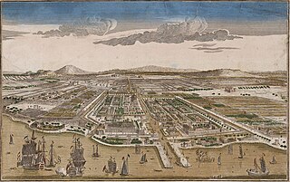
Jakarta is Indonesia's capital and largest city. Located on an estuary of the Ciliwung River, on the northwestern part of Java, the area has long sustained human settlement. Historical evidence from Jakarta dates back to the 4th century CE, when it was a Hindu settlement and port. The city has been sequentially claimed by the Indianized kingdom of Tarumanegara, the Hindu Kingdom of Sunda, the Muslim Sultanate of Banten, and by Dutch, Japanese and Indonesian administrations. The Dutch East Indies built up the area before it was taken during World War II by the Empire of Japan and finally became independent as part of Indonesia.

<span class="mw-page-title-main">Jakarta Art Building</span> Concert hall in Jakarta

The Jakarta Art Building, historically known as Schouwburg Weltevreden, is a concert hall in Sawah Besar, Central Jakarta, Indonesia, built during the colonial period in Batavia, Dutch East Indies.

<span class="mw-page-title-main">Pasar Baru</span> Subdistrict in Jakarta, Indonesia

Pasar Baru is an subdistrict in the Sawah Besar district in Central Jakarta, Indonesia. It has postal code of 10710.

Kwitang is an administrative village (kelurahan) in the subdistrict (kecamatan) of Senen, Central Jakarta. It is one of the historic administrative village of Jakarta. The boundary of Kwitang is the Ciliwung to the west, Jalan Kramat Kwitang to the north, Jalan Kramat Raya to the east, and Jalan Kramat 4 to the south.

<span class="mw-page-title-main">Toko Tio Tek Hong</span> Store in Jakarta, Indonesia

Toko Tio Tek Hong was one of the earliest modern department stores in colonial Indonesia, founded in 1902 by the prominent businessman Tio Tek Hong (1877–1965).

<span class="mw-page-title-main">Lapangan Banteng</span> Urban park in Tanah Abang, Jakarta, Indonesia

Lapangan Banteng is a historic square located in a historic area formerly known as Weltevreden, today Sawah Besar subdistrict, Central Jakarta, Indonesia.

<span class="mw-page-title-main">Jalan Gajah Mada and Jalan Hayam Wuruk</span> Major thoroughfare in Jakarta, Indonesia

Jalan Gajah Mada and Jalan Hayam Wuruk, formerly Molenvliet West and Molenvliet Oost respectively, is a major thoroughfare located in Jakarta, Indonesia. The two streets with its canal, the Batang Hari, connect Glodok and Kota Tua Jakarta to the north with Harmoni Junction to the south. Completed in late 1640s, the canal-street Gajah Mada and Hayam Wuruk is Jakarta's oldest major thoroughfare.

<span class="mw-page-title-main">Sawah Besar railway station</span> Railway station in Indonesia

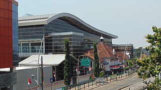
Sawah Besar Station is a railway station, located on Jl. Kyai Haji Samanhudi. Altitude this station is 15 meters amsl, this station is one of seven elevated stations on Jakarta railway's Jakarta Kota–Manggarai segment, and is named after the Jakarta subdistrict with the same name. Pasar Baru market is within walking distance from this station.

<span class="mw-page-title-main">West Irian Liberation Monument</span> Historic site in Jakarta, Indonesia

West Irian Liberation Monument is a postwar modernist monument located in Jakarta, Indonesia. It is located in the center of Lapangan Banteng in Sawah Besar, Central Jakarta. Sukarno, then President of Indonesia, commissioned the monument in 1963 following the West New Guinea dispute in which Indonesia received the territory of Western New Guinea from the Netherlands.

<span class="mw-page-title-main">Baru Timur River</span> River in Jakarta, Indonesia

Baru Timur River is a man-made canal flowing from Ci Liwung in Bogor Regency to Jakarta, Indonesia. It was one of two canals built in the 18th century under the order of Governor-General Gustaaf Willem van Imhoff originally to transport agricultural harvest from Bogor to Batavia. Currently, both canals, now known as Kali Baru Timur and Kali Baru Barat, are among the main rivers in Jakarta, and part of the Ciliwung Cisadane flood control project. Baru Timur River flows from the Katulampa flood gate, built at the same time as the canal, along the major road Bogor Highway, passing Cimanggis, Depok, Cilangkap, until reaching the Java Sea in Kali Besar, Tanjung Priok, North Jakarta.

Prinsen Straat, or Prince Street in English, was one of the busiest main streets in Batavia, Dutch East Indies where business and trade took place. It is now called Jalan Cengkeh in Jakarta. Jalan Cengkeh is located in the main area surrounding Kota Tua.

References

  1. 1 2 3 4 5 6 Merrillees 2000, p. 11.
  2. Churchill 1746.
  3. Mulyawan Karim 2009, pp. 91–2.
  4. 1 2 3 Merrillees 2000, p. 189.

Cited works