Jakarta, officially the Special Capital Region of Jakarta and formerly known as Batavia until 1949, is the nation's capital city and the centre of the largest metropolis of Indonesia. Lying on the northwest coast of Java, the world's most populous island, Jakarta is the largest metropole in Southeast Asia, and serves as the diplomatic capital of ASEAN. Jakarta is bordered by two provinces: West Java to the south and east; and Banten to the west. The Special Capital Region has a status equivalent to that of a province. Its coastline faces the Java Sea to the north, and it shares a maritime border with Lampung to the west. Jakarta's metropolitan area is ASEAN's second largest economy after Singapore.

North Jakarta is one of the five administrative cities which form Special Capital Region of Jakarta, Indonesia. North Jakarta is not self-governed and does not have a city council, hence it is not classified as a proper municipality. It contains the entire coastal area within the Jakarta Special Capital Region. North Jakarta, along with South Jakarta is the only two cities in Jakarta to border Banten and West Java. It is also the only city of Jakarta with a coastline and thus not landlocked. North Jakarta, an area at the estuary of Ciliwung river was the main port for the kingdom of Tarumanegara, which later grew to become Jakarta. Many historic sites and artefacts of Jakarta can be found in North Jakarta. Both ports of Tanjung Priok and historic Sunda Kelapa are located in the city. The city, which covers an area of 139.99 km2, had 1,645,659 inhabitants at the 2010 census and 1,778,981 at the 2020 census; the official estimate as at mid 2023 was 1,801,963. It has its administrative centre in Tanjung Priok.

The Ciliwung is a 119km long river in the northwestern region of Java where it flows through two provinces, West Java and the special region of Jakarta. The natural estuary of the Ciliwung, known as the Kali Besar, was an important strategic point for trade in the precolonial and colonial periods and was instrumental in the founding of the port city of Jakarta, but has been lost from a reorganization of the watercourse of the rivers around the area into canals.
Gambir is a district in the administrative city of Central Jakarta, Indonesia.. It is characterized by many historic buildings from the colonial era. It hosts some of the foremost political and learning/tourism features of the capital. The Merdeka Palace, the National Museum, the headquarters of the Indonesian Scout Movement and the Merdeka Square are among these.
Pluit is an administrative village (kelurahan) located in Penjaringan, Jakarta. In majority, of its residents are mainly inhabited by ethnic Chinese Indonesians. Pluit is a bustling area with residential and commercial establishments supported by modern amenities.

Cengkareng is a district (kecamatan) on West Jakarta, Indonesia. The Duri-Tangerang and Tangerang-Jakarta railways pass through Cengkareng.

Kemayoran is a district (kecamatan) of Central Jakarta, Jakarta in Indonesia. It was best known for the former Kemayoran Airport and it has been transforming as a new central business district. As of 2023, it consists of numerous four and five-star hotels, restaurants, premium office towers, hospitals as well as shopping and entertainment centers. Kemayoran is also home to the Jakarta Fair, the largest and longest fair in Southeast Asia that attracts more than 4 million visitors annually.

Pademangan is a port-associated district (kecamatan) of North Jakarta Administrative City, Indonesia. It stretches from the Sunda Kelapa Harbour in the west to the western area of Tanjung Priok Harbor in the east. Geographically, it is a plain with an average height of 75 centimeters above the high tide sea level.

Kota Tua Jakarta, officially known as Kota Tua, is a neighborhood comprising the original downtown area of Jakarta, Indonesia. It is also known as Oud Batavia, Benedenstad, or Kota Lama.
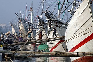
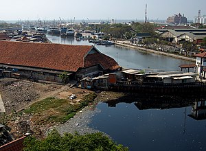
Sunda Kelapa is the old port of Jakarta, located on the estuary of the Ciliwung River. "Sunda Kalapa" is the original name, and it was the main port of the Sunda Kingdom. The port is situated in Penjaringan District, of North Jakarta, Indonesia. Today the old port only accommodates pinisi, a traditional two-masted wooden sailing ship providing inter-island freight service in the archipelago. Although it is now only a minor port, Jakarta has its origins in Sunda Kelapa and it played a significant role in the city's development. The port is currently operated by the state-owned Indonesia Port Corporations.

The Maritime Museum is located in the old Sunda Kelapa harbor area in Penjaringan Administrative Village, Penjaringan Subdistrict, Jakarta, Indonesia. The museum was inaugurated inside the former Dutch East India Company warehouses. The museum focuses on the maritime history of Indonesia and the importance of the sea to the economy of present-day Indonesia.

Ancol is a coastal lowland area located to the east of Kota Tua Jakarta in northern Jakarta, in Indonesia. The coastal lowland stretched from Kota Tua Jakarta to the west and Tanjung Priok to the east. Today, Ancol contains the main beach resort of Jakarta. Taman Impian Jaya Ancol, the largest integrated tourism area in Southeast Asia, is located in Ancol.

Pantai Indah Kapuk (PIK) is an integrated township, located in parts of Penjaringan, North Jakarta and Kapuk, West Jakarta, Indonesia. It is one of the most prestigious residential areas in Jakarta along with Menteng, Pondok Indah, and Puri Indah.

The Luar Batang Mosque is one of the oldest mosques in Jakarta, Indonesia, located in the area of Pasar Ikan in North Jakarta on the west side of the Sunda Kelapa Harbor. The mosque was built in the 18th century and named after Luar Batang, in accordance with the nickname of a sacred guardian of Islam, Habib Luar Batang, where his shrine is also located.

The Angke River is a 91.25-kilometre (56.70 mi) long river in Jakarta, Indonesia. The river flows from the Bogor area of West Java, passing through the cities of Tangerang (Banten) and Jakarta into the Java Sea via the Cengkareng Drain. The river is connected with the Cisadane River by the Mookervaart Canal.
Muara Angke mangrove forest and wildlife sanctuary is a protected nature conservation area at Kapuk Muara, Penjaringan along the north coast of Jakarta, Indonesia. Muara Angke Wildlife Sanctuary is located at the end of Muara Karang Raya street, near Mediterranean Gallery shopping complex.

Sunda Kelapa Lighthouse is a lighthouse located in Jakarta, Indonesia. Established in the mid-19th-century, it is among the oldest modern lighthouses in Indonesia.
The following outline is provided as an overview of and topical guide to Jakarta:
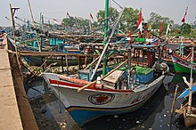
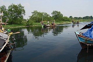
Muara Angke is a fishing port located at Kapuk Muara, Penjaringan, along the north coast of Jakarta, Indonesia. The port is integrated with fishermen's housing and a fishing port management office owned by the Jakarta government. It has a modern fish market with supporting facilities for landing and auction of fish. The port is located at the mouth of the Angke River, where it meets the Java Sea. Muara Angke Wildlife Reserve is also located in this area, adjacent to Muara Karang.