Kebon Jeruk

Last updated
Kebon Jeruk Tollway exit ramp CorollaAltisZZE142KebonJerukExit.jpg
Kebon Jeruk Tollway exit ramp
Kebon Jeruk Jakarta Kebon Jeruk.PNG
Kebon Jeruk

Kebon Jeruk (Indonesian for "orange garden") is a subdistrict (kecamatan) of West Jakarta, Indonesia. Kebon Jeruk is roughly bounded by Kali Pesanggrahan creek to the west, Kebayoran Lama Road to the south, Daan Mogot Road to the north, and Rawa Belong - Batu Sari Road to the east. The area is approximately 18 square km.

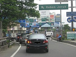
The Jakarta–Tangerang Toll Road passes through the subdistrict, connecting Jakarta to Merak in Banten Province. The major streets in Kebon Jeruk are Panjang Road, Arjuna Utara (North Arjuna) and Arjuna Selatan (South Arjuna) Roads, and Perjuangan Road.

Kelurahan (administrative villages)

The subdistrict of Kebon Jeruk is divided into seven kelurahan or administrative villages:

List of important places

Related Research Articles

<span class="mw-page-title-main">Gambir, Jakarta</span>

Gambir is a district of Central Jakarta, Indonesia. It is characterized by many historic buildings from the colonial era. It hosts some of the foremost political and learning/tourism features of the capital. The Merdeka Palace, the National Museum, the headquarters of the Indonesian Scout Movement and the Merdeka Square are among these.

<span class="mw-page-title-main">Kembangan, Jakarta</span>

Kembangan is a district in West Jakarta, Indonesia. Kembangan is bounded by Pesanggrahan Subdistrict to the south, Tangerang Regency to the south and west, Cengkareng Subdistrict to the north, and Kebon Jeruk Subdistrict to the east. The City Hall of West Jakarta is located in this district.

<span class="mw-page-title-main">Palmerah</span>

Palmerah is a subdistrict of West Jakarta, Indonesia. The Subdistrict is roughly bounded by Jakarta-Merak Tollway to the north, Batusari - Rawa Belong Road to the west, Palmerah Barat - Palmerah Utara Road to the south, and Aipda K. Sasuit Tubun Road - Western Flood Canal to the east.

<span class="mw-page-title-main">Tambora, Jakarta</span> Subdistrict of West Jakarta, Indonesia

Tambora is a subdistrict of West Jakarta, Indonesia. Tambora Subdistrict is bounded by a railway to the west and to the north, Kali Krukut - Kali Besar canal to the east, and Duri Selatan Road to the south.

<span class="mw-page-title-main">Matraman</span>

Matraman is a district (kecamatan) of East Jakarta, Indonesia. Matraman is the smallest district of East Jakarta. The boundaries of Matraman are: Bekasi Barat Raya Road to the south, Prof Wiyoto Witono MSc Highway to the east, Pramuka Road to the north, and Ciliwung River to the west.

<span class="mw-page-title-main">Kebayoran Lama</span>

Kebayoran Lama is a district of South Jakarta, Indonesia. The rough boundaries of Kebayoran Lama are: Kebayoran Lama Road – Palmerah Barat Road to the north, Grogol River to the east, Jakarat Outer Ring Road to the south, and Pesanggrahan River to the west.

<span class="mw-page-title-main">Tebet, South Jakarta</span>

Tebet is a district of South Jakarta, one of the administrative cities which form the Capital Region of Jakarta, Indonesia. The boundaries of Tebet are Jend. Gatot Subroto-Letjen Haryono MT. tollway to the south, Ciliwung River to the east, Jalan Casablanca - Ciliwung River to the north, and Cideng River to the west. This district is home to SMA Negeri 8 Jakarta

Koja is a subdistrict of North Jakarta, Indonesia. It is known as the location of Kampung Tugu, a historic Portuguese-influenced neighborhood in North Jakarta.

North Rawa Badak is administrative village at Koja subdistrict, North Jakarta. The border of Rawa Badak Utara are :

Senayan is an administrative village at Kebayoran Baru subdistrict, South Jakarta, Indonesia. The post code is 12190.

<span class="mw-page-title-main">Trans-Java Toll Road</span> Toll road network in Java, Indonesia

The Trans-Java Toll Road is a tolled expressway network that runs from Merak, northwestern end of Java to Banyuwangi, the eastern end of the island in Indonesia. The toll road connects all major cities of the island. The total length of the road is 1,167 kilometres (725 mi).

<span class="mw-page-title-main">Kedoya Selatan</span> Administrative village in DKI Jakarta, Indonesia

Kedoya Selatan is an administrative village in the Kebon Jeruk district, city of West Jakarta, Indonesia. It has postal code of 11520.

Kedoya Utara is an administrative village in the Kebon Jeruk district, city of West Jakarta, Indonesia. It has postal code of 11520, the same as Kedoya Selatan.

<span class="mw-page-title-main">Esa Unggul University</span> University in Jakarta, Indonesia

The Esa Unggul University is a private university and powered by Arizona State University and located in 3 different areas in Greater Jakarta, Indonesia. Esa Unggul University was established on October 1, 1986.

Jalan Daan Mogot is one of the main avenue of greater Jakarta, Indonesia. The road is named after a military officer involved in the struggle for Indonesian independence Daan Mogot. This road stretches along 27.5 KM from Grogol, West Jakarta to Sukarasa, Tangerang, Tangerang. After entering Tangerang, this road continues to Jalan Merdeka and Jalan Gatot Subroto .This road is part of Indonesian National Route 1. This road crosses 14 urban villages, namely

Sukabumi Utara is an administrative village in the Kebon Jeruk district, city of West Jakarta, Indonesia. It has postal code of 11540.

Sukabumi Selatan is an administrative village in the Kebon Jeruk district, city of West Jakarta, Indonesia. It has postal code of 11560.