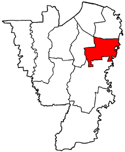
Cilandak is a district in the administrative city of South Jakarta, Indonesia. The Krukut River flows through the eastern edge of Cilandak, while the Pesanggrahan and Grogol Rivers flow through the western edge.

South Jakarta, abbreviated as Jaksel, is one of the five administrative cities which form the Special Capital Region of Jakarta, Indonesia. South Jakarta is not self-governed and does not have a city council, hence it is not classified as a proper municipality. It covers a land area of 141.27 km2, and had a population of 2,062,232 at the 2010 census and 2,226,812 at the 2020 census, and 2,409,380 as at mid 2022 according to the official estimates. It is the third most populous among the five administrative cities of Jakarta, after East Jakarta and West Jakarta. The administrative centre is at Kebayoran Baru.
Gambir is a district in the administrative city of Central Jakarta, Indonesia.. It is characterized by many historic buildings from the colonial era. It hosts some of the foremost political and learning/tourism features of the capital. The Merdeka Palace, the National Museum, the headquarters of the Indonesian Scout Movement and the Merdeka Square are among these.

Duren Sawit is a district (kecamatan) of East Jakarta, Indonesia. The rough boundaries of Duren Sawit are I Gusti Ngurah Rai road to the north, Kali Sunter to the west, and Kali Malang to the south. The district borders the districts of Jatinegara to the west, Cakung and Pulo Gadung to the north, and Makasar to the south, and Bekasi to the east.

Pasar Minggu is a district in the administrative city of South Jakarta, Indonesia. The area is known for its traditional Sunday market, famous for the fruit market. Historically, Pasar Minggu is a fruit cultivation area developed by the Dutch government during the colonial period. The central point of the cultivation area is the traditional market of Pasar Minggu, located in what is now the lower-division Pasar Minggu subdistrict. Teak forest could also be found in the Pasar Minggu district, notably around the Jati Padang subdistrict. Most of these areas have been converted into residential areas as Jakarta grows southward.

Grogol Petamburan is a district of West Jakarta, Indonesia, roughly bounded by the West Flood Canal to the east, Angke Canal to the west and to the north, and Jakarta-Merak Tollway to the south. It has an area of 9.99 km2. As of 2004, the use of the land was 58.0% for housing, 12.5% for offices, 3.8% in parkland, and 2.2% in farmland with the remainder in other uses or idle. The official estimate of population as at mid 2023 was 237,367.
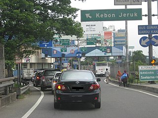
Kebon Jeruk is a district (kecamatan) of West Jakarta Administrative City, Indonesia. Kebon Jeruk is roughly bounded by Kali Pesanggrahan creek to the west, Kebayoran Lama Road to the south, Daan Mogot Road to the north, and Rawa Belong - Batu Sari Road to the east. The area is approximately 17.54 square km, and the official estimate of population as at mid 2023 was 370,282.

Palmerah is a district (kecamatan) of West Jakarta Administrative City, Indonesia. The district is roughly bounded by Jakarta-Merak Tollway to the north, Batusari - Rawa Belong Road to the west, Palmerah Barat - Palmerah Utara Road to the south, and Aipda K. Sasuit Tubun Road - Western Flood Canal to the east.

Mampang Prapatan is a district in the administrative city of South Jakarta, Indonesia. The expatriate residential areas of Bangka and Kemang, known for their annual Kemang Festival, are located in the Mampang Prapatan District. The boundaries of Mampang Prapatan are Krukut River to the west, Cideng River and Mampang River to the east, Jalan Jenderal Gatot Subroto Tollway to the north, and Kemang Selatan-Kemang Timur Road to the south. Mampang Prapatan Main Road passed through Mampang Prapatan District. The expatriate neighborhood Kemang partly located in this district.

Nias Regency is a regency in North Sumatra province, Indonesia; it lies on the east side of Nias Island. The regency originally covered the entire island, but was reduced to the northern half, with an area of 3,495.39 square kilometres, following the creation of the new regency of Nias Selatan on 25 February 2003. It was further reduced by the creation of the new regencies of Nias Utara and Nias Barat and the independent municipality of Gunungsitoli from other parts of Nias Regency on 29 October 2008. Since the separation of the new regencies and municipality, the reduced Regency now covers 853.44 km2 of land in the eastern part of the island, and had a population of 131,377 at the 2010 Census and 146,672 at the 2020 Census; the official estimate as at mid 2023 was 153,658. Its seat is the town of Gido.
South Halmahera Regency is a regency of North Maluku Province, Indonesia. It lies partly on Halmahera Island and partly on smaller islands to the west and south of Halmahera. It covers a land area of 8,779.32 km2, and at the 2010 Census it had a population of 198,911 people, while the 2020 Census showed that this had risen to 248,395 and the official estimate in mid 2023 was 255,384 The capital lies at the town of Labuha on Bacan Island.
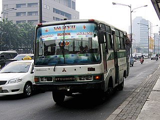
Koperasi Angkutan Jakarta or Kopaja was a cooperative established in 1971 to provide public transport services in Jakarta. There were reportedly over 1,400 minibuses in the Kopaja fleet in mid-2012, more than half of which were estimated to be over 20 years old.

Tanimbar Islands Regency is a regency of Maluku province, Indonesia, consisting primarily of the Tanimbar Islands. The Regency covers a land area of 10,102 km2, and it had a population of 105,341 at the 2010 Census and 123,572 at the 2020 Census; the official estimate as at mid 2022 was 124,787. The principal town and administrative centre lies at Saumlaki in Tanimbar Selatan District.

Manokwari Regency is a regency in West Papua, Indonesia. Following the splitting away of twenty of its former districts in 2013, it now covers an area of 2,762.89 km2 and had a population of 192,663 at the 2020 Census; the official estimate as at mid 2023 was 201,821. The administrative centre is presently at the town of Manokwari, which is also the capital of the province.

The Thousand Islands are a chain of islands to the north of Jakarta's coast. It forms the only regency of Special Capital Region of Jakarta, the metropolitan province of Indonesia. It consists of a string of 342 islands stretching 45 km (28 mi) north into the Java Sea at West Jakarta Bay and in fact are located to the north of Banten Province. Pramuka Island is the regency seat. The islands, along with North Jakarta City, are the only administrative divisions of Jakarta Special Capital Region with a coastline.
In Indonesia, district is the third-level administrative subdivision, below regency or city. The local term kecamatan is used in the majority of Indonesian areas. The term distrik is used in provinces in Papua. In the Special Region of Yogyakarta, the term kapanewon is used for districts within the regencies, while the term kemantren is used for districts within Yogyakarta, the province's only city. According to Statistics Indonesia, there are a total of 7,252 districts in Indonesia as at 2019, subdivided into 83,820 administrative villages. An average number of districts in the provinces of Indonesia is 190 districts, with an average area of 262.62 km2 (101.40 sq mi), and an average population of about 38,488 people.
South Buton Regency is a regency located on Buton Island in Southeast Sulawesi Province of Indonesia. This regency was formed from the southern part of Buton Regency, from which it was separated by Act No.16 of 2014, dated 23 July 2014. It covers an area of 546.58 km2, and the population of the districts now comprising the new regency was 74,974 at the 2010 Census and 95,261 at the 2020 Census; the official estimate as at mid 2023 was 101,635. The regency capital is located in Batauga.

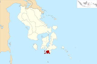
Tukak Sadai is a district of South Bangka Regency, Bangka-Belitung Islands. The district is located in the southeastern section of Bangka Island, and contains the Sadai seaport.
Payung is a district of South Bangka Regency, Bangka-Belitung Islands. It is located in the northern part of the regency, bordering the Central Bangka Regency.

Muaradua, or usually spelled as Muara Dua, is a town and administrative district (kecamatan) in South Ogan Komering Ulu Regency, of South Sumatra province of Indonesia and it is the seat (capital) of South Ogan Komering Ulu Regency.