History
Cipinang river has the upstream in Depok, West Java, and flowing to the direction of Banjir Kanal Timur and Sunter River. Its water used to be very clear, that the local people utilized it for bathing, before more people settled there. There were many types of fish found along the river: tilapia, Java barb, and catfish. [6] Its width reached seven meter with a depth of four meter. [6]
However, in the last ten years more houses were erected on both banks. The river became narrower and its water quality was neglected, until it turned black and heavily polluted from various industrial sources. [6] Former ponds on its banks were turned into trash collection mounds. Therefore, during the rain season the river often causes flooding to the surrounding area. [6] According to the local residents, the worst flood was in 2015. In January 2017, after the normalization was initiated, the condition improved, but the flooding still happened. [7]

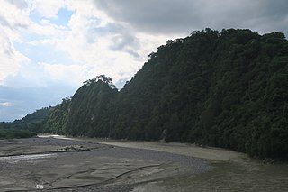
The Ciliwung is a 119km long river in the northwestern region of Java where it flows through two provinces, West Java and the special region of Jakarta. The natural estuary of the Ciliwung river, known as the Kali Besar, was an important strategic point for trade in the precolonial and colonial periods and was instrumental in the founding of the port city of Jakarta, but has been lost from reorganization of the watercourse of the rivers around the area into canals.
The Mina River is a river of Timor, in the province of East Nusa Tenggara, Indonesia, about 2000 km east of the capital Jakarta. Above this river also stretches the Noelmina Bridge which connects Kupang with the South Central Timor Regency.

The Manuk River is a river in West Java, Indonesia, about 170 km east of the capital Jakarta.

Flooding in Jakarta occurs on the northwest coast of Java, at the mouth of the Ciliwung River on Jakarta Bay, which is an inlet of the Java Sea and has happened recently in 1996, 1999, 2007, 2013, and 2020.

The Jakarta Flood Canal refers to two canals that divert floods from rivers around Jakarta instead of going through the city. This first flood control channel was designed by Hendrik van Breen, an engineer working for the Dutch East Indian Department van Burgelijke Openbare Werken, after a big flood hit the city on 13 February 1918.
The Angke River is a 91.25-kilometre (56.70 mi) long river in Jakarta, Indonesia. The river flows from the Bogor area of West Java, passing through the cities of Tangerang (Banten) and Jakarta into the Java Sea via the Cengkareng Drain. The river is connected with the Cisadane River by Mookervaart Canal.
The Grogol River is a small river in the western part of the Special Capital Region of Jakarta, Indonesia. The lower portions of the original river have been channelized with levees built along its banks, but flooding remains a real concern. Illegal buildings built along its banks were removed in 2014, and fifty-eight village families were provided with replacement housing, but most of them could not be accommodated.
The Sunter River or Kali Sunter is a river that flows in the eastern part of Jakarta, Indonesia. The river is about 37 km long and has 73,184,092 m2 of river basin. Neighborhoods along the Kali Sunter are very densely populated and prone to frequent flooding.
The Madiun River is a river in East Java, Indonesia, about 500 km to the east of the capital Jakarta. It is the largest tributary of the Solo River. Its name indicates that it passes through the major city of Madiun, East Java, Indonesia. This river starts as a number of smaller tributaries converging near the city of Ponorogo, in particular the Kali Slahung, Kali Keyang and Kali Sungkur. It eventually converges with the Solo River near the city of Ngawi.
The Kambaniru River is a river in the island of Sumba, Indonesia, about 1,500 km east of the capital Jakarta. With a length of approximately 118 km, it flows periodically through 9 districts in the East Sumba Regency, exiting to the Bay of Kambaniru near the city of Waingapu to the Sawu Sea, with high debit in the wet season, but very low in the dry season.
The Mookervaart River is a canal connecting the Cisadane River in Tangerang and Kali Angke in Jakarta. Constructed from 1678 to 1689, this 25–30 meter wide channel is one of the important flood control water channels in Jakarta.
The Pesanggrahan River is a river with the upstream in the Bogor Regency, flowing through the cities of Depok, Jakarta and Tangerang, Banten. The river passes the districts of Tanah Sereal, Bojong Gede, Sawangan, Limo, Kebayoran Lama, Pesanggrahan, Kembangan, and Kebun Jeruk before flowing into the Cengkareng Drain. Based on 2005 data, 55 percent of the watershed area of the Pesanggrahan River is occupied by housing, only 7 percent is still forests, 20 percent rice fields, and 13 percent other agriculture fields.
The Krukut River is a river flowing in Jakarta originating in Bogor Regency. In the past the river was clean and one of the tourist attractions during the Dutch East Indies administration, but due to denser housing on the banks and lack of maintenance, the water turned dark and filled with trash, causing routine flooding in rainy seasons.
The Jatikramat River is a river in Bekasi, West Java, and the eastern part of the Special Capital Region of Jakarta, Indonesia. The lower portions of the original river have been channelized and directed into the eastern flood canal, "Banjir Kanal Timur", which continues to flow to the Java Sea in the district of Marunda, Cilincing, North Jakarta. The river regularly causes flooding in the city of Bekasi and Jakarta.
Cakung River is a river in the Bekasi, West Java and eastern part of the Special Capital Region of Jakarta, Indonesia. The lower portions of the original river have been channelized and directed into the eastern flood canal, "Banjir Kanal Timur", which continues to flow to the Java Sea in the district of Marunda, Cilincing, North Jakarta. The river regularly causes flooding in the city of Bekasi and Jakarta.
The Buaran River is a river flowing in the Bekasi, West Java and eastern part of the Special Capital Region of Jakarta, Indonesia. The lower portions of the original river have been channelized and directed into the eastern flood canal, "Banjir Kanal Timur", which continues to flow to the Java Sea in the district of Marunda, Cilincing, North Jakarta. The river regularly causes flooding in the city of Bekasi and Jakarta.
Baru Timur River is a man-made canal flowing from Ci Liwung in Bogor Regency to Jakarta, Indonesia. It was one of two canals built in the 18th century under the order of the Governor-General Gustaaf Willem van Imhoff originally to transport agriculture harvest from Bogor to Batavia. Currently both canals, now known as Kali Baru Timur and Kali Baru Barat, are among the main rivers in Jakarta, and part of the Ciliwung Cisadane flood control project. Baru Timur River flows from Katulampa flood gate, built at the same time as the canal, along the major road Bogor Highway, passing Cimanggis, Depok, Cilangkap, until reaching Java Sea in Kali Besar, Tanjung Priok, North Jakarta.
The Baru Barat River is a man-made canal flowing from the Cisadane River in Bogor Regency to Jakarta, Indonesia. It was one of two canals built in the 18th century under the order of the Governor-General Gustaaf Willem van Imhoff, the other being the Baru Timur River. Both canals were originally built to transport agricultural harvests from Bogor to Batavia. They are among the main rivers in Jakarta, and part of the Ciliwung Cisadane flood control project. The Baru Barat River flows through the districts of Pancoran and Tebet in South Jakarta, and drains into the Banjir Kanal Barat.
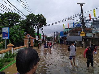
Flash floods occurred throughout the Indonesian capital of Jakarta and its metropolitan area on the early hours of 1 January 2020, due to the overnight rain which dumped nearly 400 millimetres (15 in) of rainwater, causing the Ciliwung and Cisadane rivers to overflow. At least 66 people have been killed, and 60,000 displaced in the worst flooding in the area since 2007.


