Sungi River

Last updated

Sungi River
Sungai Sungi
Native nameTukad Sungi (Sundanese)
Location
CountryIndonesia
State Bali
Physical characteristics
Mouth Yeh Sungi [1]
  location
Badung Regency
  elevation
6 m (20 ft)
Indonesia Bali location map.svg
Arrows 12x12 ne.svg
Yeh Sungi
Arrows 12x12 s.svg
Tukad Sungi
Sungi River source and mouth in Bali

The Sungi River is a river in Bali, Indonesia. [2] [3] Its source is located in the mountainous area in the central-northern part of Bali. It flows through the ancient site of Mengwi and enters the sea to the west of Kerobokan Kelod on the southern coast. [4]

Contents

The Sungi River forms most of the eastern boundary of the Tabanan Regency and provides irrigation water for 4,200 ha of sawah (rice paddies) within one regency (kabupaten) alone.

History

The first King of Mengwi, the Lord of Balayu, built a dam over the Sungi River. [5] According to Henk Schulte Nordholt, this dam was very important for the economy along the river bank, providing needed irrigation for the people to prosper. [4]

Geography

The river flows in the middle to the south of Bali with a predominantly tropical rainforest climate (designated as Af in the Köppen-Geiger climate classification). [6] The annual average temperature in the area is 24 °C. The warmest month is October when the average temperature is around 25 °C, and the coldest is July, at 22 °C. [7] The average annual rainfall is 2123 mm. The wettest month is January, with an average of 569 mm of rainfall, and the driest is September, with 23 mm of rainfall. [8]

Sungi River
Climate chart (explanation)
J
F
M
A
M
J
J
A
S
O
N
D
 
 
569
 
 
27
21
 
 
257
 
 
26
22
 
 
255
 
 
26
22
 
 
117
 
 
26
22
 
 
127
 
 
27
21
 
 
98
 
 
26
21
 
 
86
 
 
25
19
 
 
24
 
 
25
19
 
 
23
 
 
27
20
 
 
30
 
 
29
21
 
 
173
 
 
28
21
 
 
365
 
 
27
21
Average max. and min. temperatures in °C
Precipitation totals in mm
Source: [7]
Imperial conversion
JFMAMJJASOND
 
 
22
 
 
81
70
 
 
10
 
 
79
72
 
 
10
 
 
79
72
 
 
4.6
 
 
79
72
 
 
5
 
 
81
70
 
 
3.9
 
 
79
70
 
 
3.4
 
 
77
66
 
 
0.9
 
 
77
66
 
 
0.9
 
 
81
68
 
 
1.2
 
 
84
70
 
 
6.8
 
 
82
70
 
 
14
 
 
81
70
Average max. and min. temperatures in °F
Precipitation totals in inches

See also

Related Research Articles

<span class="mw-page-title-main">Brantas River</span> River in East Java in Indonesia

The Brantas is the longest river in East Java, Indonesia. It has a length of 320 km, and drains an area of over 11,000 km2 from the southern slope of Mount Kawi-Kelud-Butak, Mount Wilis, and the northern slopes of Mount Liman-Limas, Mount Welirang, and Mount Anjasmoro. Its course is semi-circular or spiral in shape: at its source, the river heads southeast, but gradually curves south, then southwest, west, then north, and finally it flows generally eastward at the point where it branches off to become the Kalimas and Porong River.

<span class="mw-page-title-main">Asahan River</span> River in North Sumatra, Indonesia

The Asahan River is one of the principal rivers in North Sumatra, Indonesia, that begins in Porsea, Toba Regency near the southeast corner of Lake Toba.

<span class="mw-page-title-main">Indragiri River</span> River in Indonesia

The Indragiri River is a river in Sumatra, in the Indonesian province of Riau, about 800 km northwest of the capital Jakarta. Formed by the union of the Ombilin River and the Sinamar River, the Indragiri empties into the Strait of Malacca. The middle part that flows in the Kuantan Singingi Regency is called Batang Kuantan.

The Bohorok River is a river of the Langkat Regency in North Sumatra province, Indonesia, about 1,400 km northwest of the capital Jakarta. It is a tributary of Wampu River.

<span class="mw-page-title-main">Mina River (Indonesia)</span> River in Indonesia

The Mina River is a river of Timor, in the province of East Nusa Tenggara, Indonesia, about 2000 km east of the capital Jakarta. Above this river also stretches the Noelmina Bridge which connects Kupang with the South Central Timor Regency.

<span class="mw-page-title-main">Asem River</span> River in Java, Indonesia

Asem River is a river in northern West Java province on Java island, Indonesia. The river rises on Mount Tangkuban Perahu and discharges into the Bay of Ciasem, Java Sea, traversing Ciasem, Subang Regency, around 90 km east of the capital Jakarta.

Pemali River is a river in northern Central Java, Indonesia, about 250 km east of the capital Jakarta.

The Porong River is a river flowing through Sidoarjo, East Java, Indonesia, about 700 km east of the capital Jakarta. It is one of the main distributaries of the Brantas River that discharges into the Bali Sea, close to the Madura Strait, and is the main outlet for the Lusi mudflow.

<span class="mw-page-title-main">Serayu River</span> River in Central Java, Indonesia

The Serayu River is a river in Central Java, Indonesia, about 300 km southeast of the capital Jakarta.

Barumun River is a Sumatran river that begins in Siraisan, Padang Lawas Regency in the southeastern North Sumatra, Indonesia, about 1,200 km northwest of the capital Jakarta.

Mandau River is a river in Riau province of central Sumatra island, Indonesia, about 1,000 km northwest of the capital Jakarta. It is a tributary of the Siak River.

<span class="mw-page-title-main">Ombilin River</span> River in Indonesia

The Ombilin River is a river in West Sumatra, Indonesia, about 900 km northwest of the capital Jakarta.

<span class="mw-page-title-main">Rokan River</span> River in Riau, Indonesia

Rokan River is a river in Riau province, central-eastern Sumatra, Indonesia, about 1,100 km northwest of the capital Jakarta.

<span class="mw-page-title-main">Wampu River</span> River in North Sumatra, Indonesia

The Wampu River is a river in North Sumatra, Indonesia, about 1500 km northwest of the capital Jakarta.

<span class="mw-page-title-main">Kaso River (Garut)</span> River in Indonesia

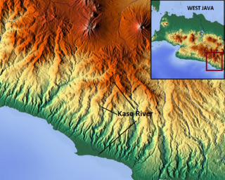
The Kaso River, also Ci Kaso, is a river in the Garut Regency of West Java, Indonesia, about 190 km southeast of the capital Jakarta. Coal-bearing sandstones, clays and limestones are typical geological traits of the Bandung area of southern Java. The river flow merges with the Cipalebuh River, near the center of Pameungpeuk, southern coastal area of Garut, West Java.

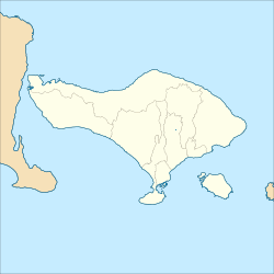
The Telaga Waja is a river which is situated in eastern Bali, Indonesia. It rises on the slope of Mount Abang and passes through towns and wilderness slopes along the region of Rendang Village, reaching the sea in Klungkung Regency.

<span class="mw-page-title-main">Tabalong River</span> River in Kalimantan (Indonesian Borneo)

The Tabalong River is a river traversing Tabalong Regency, in the province of South Kalimantan, Indonesia. The river flows into the Negara River. It is a confluence of two tributaries: the Left Tabalong and Right Tabalong rivers.

<span class="mw-page-title-main">Sambas River</span> River in Indonesia

Sambas River, or specifically referred to Big Sambas River, is a river in Sambas Regency, West Kalimantan, Indonesia. The upstream is located in Kabupaten Bengkayang, flowing through the city of Sambas, continuing to Pemangkat where it discharges into South China Sea.

The Wanokaka River is a river in Sumba island, Province of East Nusa Tenggara, Indonesia. It is located a few kilometers south of Waikabubak, with the District of Wanokaka (Wanukaka), east of the District of Lamboya.

The Simpang-kanan River is a river in southern Sumatra, Indonesia, about 600 km northwest of the capital Jakarta. It is a tributary of the Rawas River.

References

  1. Yeh Sungi at Geonames.org (cc-by); Last updated 17 January 2012; Database dump downloaded 27 November 2015
  2. Rand McNally, The New International Atlas, 1993.
  3. Tukad Sungi at Geonames.org (cc-by); Last updated 17 January 2012; Database dump downloaded 27 November 2015
  4. 1 2 J. Stephen Lansing, Murray P. Cox, Sean S. Downey, Marco A. Janssen and John W. Schoenfelder (2009). "A robust budding model of Balinese water temple networks". World Archaeology. 41: 112–133. doi:10.1080/00438240802668198. S2CID   4821372.{{cite journal}}: CS1 maint: multiple names: authors list (link)
  5. Nordholt, Henk Schulte (1996). The Spell of Power: A History of Balinese Politics, 1650–1940. KITLV Press. p. 58. ISBN   90-6718-090-4.
  6. Peel, M C; Finlayson, B L; McMahon, T A (2007). "Updated world map of the Köppen-Geiger climate classification". Hydrology and Earth System Sciences. 11 (5): 1633–1644. Bibcode:2007HESS...11.1633P. doi: 10.5194/hess-11-1633-2007 .
  7. 1 2 "NASA Earth Observations Data Set Index". NASA. 30 January 2016.
  8. "NASA Earth Observations: Rainfall (1 month – TRMM)". NASA/Tropical Rainfall Monitoring Mission. 30 January 2016.

8°29′47″S115°10′22″E / 8.4963°S 115.1729°E / -8.4963; 115.1729