
The Sunda Islands are a group of islands in the Malay Archipelago. They consist of the Greater Sunda Islands and the Lesser Sunda Islands.

The Noel Besi River is a river flowing in the west part of Timor island and forms part of the border between the East Timor exclave of Oecussi and Indonesian West Timor. It flows north into the Sawu Sea. Located 1900 km east of the Indonesian capital, Jakarta.

The Ayung River is the longest river on the Indonesian island of Bali. It runs 68.5 km from the northern mountain ranges, passing the Bangli, Badung, Gianyar regencies and the city of Denpasar, before discharging into the Badung Strait at Sanur. The river is famous for white water rafting.
The Sungi River is a river in Bali, Indonesia. Its source is located in the mountainous area in the central-northern part of Bali. It flows through the ancient site of Mengwi and enters the sea to the west of Kerobokan Kelod on the southern coast.
The Wera River is a river of Flores, East Nusa Tenggara province, Indonesia, about 1500 km east of the capital Jakarta.
The Sissa River is a river of Flores, East Nusa Tenggara, Indonesia. The 87-km river flows from a southwest to northeast direction, with the upstream at Mount Inielika north of Bajawa, Ngada Regency, and discharges into the Flores Sea near Mbay, Nagekeo Regency.
The Mina River is a river of Timor, in the province of East Nusa Tenggara, Indonesia, about 2000 km east of the capital Jakarta. Above this river also stretches the Noelmina Bridge which connects Kupang with the South Central Timor Regency.
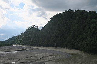
The Benanain River is a river of western Timor, Indonesia. This river is the longest and the largest di the West Timor area, with a length of 132 km. The river is located in three regencies: Malaka, Timor Tengah Utara and Timor Tengah Selatan, province East Nusa Tenggara, Indonesia. The upstream rises from Mount Mutis, flowing in the southeast direction until discharging to Timor Sea near Besikama.
The Kadumbul River is a river of Sumba, East Nusa Tenggara, Indonesia.
The Melolo River is a river of Sumba, Indonesia.
The Pono River is a river on the Indonesian part of the island of Timor, which is in the territory of the East Nusa Tenggara province, about 2000 km east of the Indonesian capital, Jakarta.
The Telaga Waja is a river which is situated in eastern Bali, Indonesia. It rises on the slope of Mount Abang and passes through towns and wilderness slopes along the region of Rendang Village, reaching the sea in Klungkung Regency.
The Kambaniru River is a river in the island of Sumba, Indonesia, about 1,500 km east of the capital Jakarta. With a length of approximately 118 km, it flows periodically through 9 districts in the East Sumba Regency, exiting to the Bay of Kambaniru near the city of Waingapu to the Sawu Sea, with high debit in the wet season, but very low in the dry season.
The Wanokaka River is a river in Sumba island, Province of East Nusa Tenggara, Indonesia. It is located a few kilometers south of Waikabubak, with the District of Wanokaka (Wanukaka), east of the District of Lamboya.
