
Banten is the westernmost province on the island of Java, Indonesia. Its capital city is Serang and its largest city is in Tangerang. The province borders West Java and the Special Capital Region of Jakarta on the east, the Java Sea on the north, the Indian Ocean on the south, and the Sunda Strait on the west and shares a maritime border with Bengkulu and Lampung to the east and Bangka Belitung Islands to the north. The province covers an area of 9,662.82 km2 (3,730.84 sq mi). It had a population of over 11.9 million in the 2020 census, up from about 10.6 million in 2010. The estimated mid-2022 population was 12.25 million. Formerly part of the province of West Java, Banten become a province in 2000. The northern half has recently experienced rapid rises in population and urbanization, and the southern half has a more traditional character but an equally fast-rising population.

Bogor is a city in the West Java province, Indonesia. Located around 60 kilometers (37 mi) south of the national capital of Jakarta, Bogor is the 6th largest city in the Jakarta metropolitan area and the 14th overall nationwide. The city covers an area of 111.39 km2, and it had a population of 950,334 in the 2010 Census and 1,043,070 in the 2020 Census. The official estimate as at mid 2023 was 1,122,772. Bogor is an important economic, scientific, cultural, and tourist center, as well as a mountain resort.

Bekasi is a city in West Java, Indonesia, located on the eastern border of Jakarta. It serves as a commuter city within the Jakarta metropolitan area. According to the 2020 Census by Statistics Indonesia (BPS), Bekasi had 2,543,676 inhabitants. The official estimate for mid 2022 was 2,590,257. It lies within the largest metropolitan area in Indonesia (Jabodetabek). The city is bordered by Bekasi Regency to the north and the east, Bogor Regency and Depok City to the south, and East Jakarta to the west.
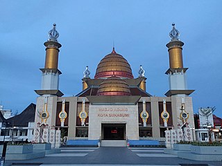
Sukabumi is a landlocked city surrounded by the regency of the same name in the southern foothills of Mount Gede, in West Java, Indonesia, about 100 km (62 mi) south of the national capital, Jakarta.

The Ciliwung is a 119km long river in the northwestern region of Java where it flows through two provinces, West Java and the special region of Jakarta. The natural estuary of the Ciliwung river, known as the Kali Besar, was an important strategic point for trade in the precolonial and colonial periods and was instrumental in the founding of the port city of Jakarta, but has been lost from reorganization of the watercourse of the rivers around the area into canals.

Bogor Regency is a landlocked regency (kabupaten) of West Java, Indonesia, south of DKI Jakarta. Covering an area of 2,986.20 km2, it is considered a bedroom community for Jakarta, and was home to 5,427,068 people at the 2020 census. The official estimate as at mid 2022 was 5,566,838. Cibinong serves as the regency seat.

Mount Salak is an eroded volcano in West Java, Indonesia. It has several satellite cones on its southeast flank and the northern foot, along with two additional craters at the summit. Mount Salak has been evaluated for geothermal power development. According to a popular belief, the name "Salak" is derived from salak, a tropical fruit with scaly skin; however, according to Sundanese tradition, the name was derived from the Sanskrit word Salaka which means "silver". Mount Salak can be translated to "Silver Mountain" or "Mount Silver".

Mount Halimun Salak National Park is a 400 km2 conservation area in the Indonesian province of West Java on the island of Java. Established in 1992, the park comprises two mountains, Mount Salak and Mount Halimun with an 11-kilometer forest corridor. It is located near the better known Mount Gede Pangrango National Park, but the national park should be accessed from Sukabumi, 2 hours drive to the administration post and then 2 hours drive again to Cikaniki post gate.

Pakuan Pajajaran was the fortified capital city of Sunda Kingdom. The location is roughly corresponds to modern Bogor city in West Java, Indonesia, approximately around the site of Batu Tulis. The site is revered as the spiritual home of Sundanese people as it contains much of shared identity and history of Sundanese people.

The Cisadane River is a 138 kilometres (86 mi) long river in northern West Java, Indonesia. Note that the prefixed syllable "Ci" means river, so to avoid tautology the true translation is "Sadane River". The river has its source at Mount Pangrango and passes through Bogor and Tangerang before flowing to the Java Sea.
Mandiri River is a river in southwestern Java of West Java province, Indonesia. It flows mainly in the Sukabumi Regency.

The Angke River is a 91.25-kilometre (56.70 mi) long river in Jakarta, Indonesia. The river flows from the Bogor area of West Java, passing through the cities of Tangerang (Banten) and Jakarta into the Java Sea via the Cengkareng Drain. The river is connected with the Cisadane River by the Mookervaart Canal.

Ciaruteun inscription also written Ciarutön or also known as Ciampea inscription is a 5th-century stone inscription discovered on the riverbed of Ciaruteun River, a tributary of Cisadane River, not far from Bogor, West Java, Indonesia. The inscription is dated from the Tarumanagara kingdom period, one of the earliest Hindu kingdoms in Indonesian history. The inscription states King Purnawarman is the ruler of Tarumanagara.
The Madiun River is a river in East Java, Indonesia, about 500 km to the east of the capital Jakarta. It is the largest tributary of the Solo River. Its name indicates that it passes through the major city of Madiun, East Java, Indonesia. This river starts as several smaller tributaries converging near the city of Ponorogo, in particular the Kali Slahung, Kali Keyang, and Kali Sungkur. It eventually converges with the Solo River near the city of Ngawi.
The Krukut River is a river flowing in Jakarta originating in Bogor Regency. In the past the river was clean and one of the tourist attractions during the Dutch East Indies administration, but due to denser housing on the banks and lack of maintenance, the water turned dark and filled with trash, causing routine flooding in rainy seasons.

The Tulang Bawang River is a river which mostly flows in Lampung, Indonesia. The river lends its name to the Tulang Bawang Regency, where it reaches the Java Sea and the West Tulang Bawang Regency. It also flows across the capital of the regency at Menggala.
The Buaran River is a river flowing in the Bekasi, West Java, and the eastern part of the Special Capital Region of Jakarta, Indonesia. The lower portions of the original river have been channelized and directed into the eastern flood canal, "Banjir Kanal Timur", which continues to flow to the Java Sea in the district of Marunda, Cilincing, North Jakarta. The river regularly causes flooding in the cities of Bekasi and Jakarta.
The Cipinang River is a river in the Special Capital Region of Jakarta, Indonesia. The Cipinang River is a tributary of Sunter River, conjoining near I Gusti Ngurah Rai Street and Cipinang Muara Ilir Street, Jakarta, but in the middle it is cut by the beginning of Banjir Kanal Timur, near Cipinang Besar Selatan Street and IPN Street, Jakarta. The river flows mainly in the district of Makassar, East Jakarta, with many houses built on both banks.
Baru Timur River is a man-made canal flowing from Ci Liwung in Bogor Regency to Jakarta, Indonesia. It was one of two canals built in the 18th century under the order of Governor-General Gustaaf Willem van Imhoff originally to transport agricultural harvest from Bogor to Batavia. Currently, both canals, now known as Kali Baru Timur and Kali Baru Barat, are among the main rivers in Jakarta, and part of the Ciliwung Cisadane flood control project. Baru Timur River flows from the Katulampa flood gate, built at the same time as the canal, along the major road Bogor Highway, passing Cimanggis, Depok, Cilangkap, until reaching the Java Sea in Kali Besar, Tanjung Priok, North Jakarta.
The Baru Barat River is a man-made canal flowing from the Cisadane River in Bogor Regency to Jakarta, Indonesia. It was one of two canals built in the 18th century under the order of the Governor-General Gustaaf Willem van Imhoff, the other being the Baru Timur River. Both canals were originally built to transport agricultural harvests from Bogor to Batavia. They are among the main rivers in Jakarta, and part of the Ciliwung Cisadane flood control project. The Baru Barat River flows through the districts of Pancoran and Tebet in South Jakarta and drains into the Banjir Kanal Barat.
