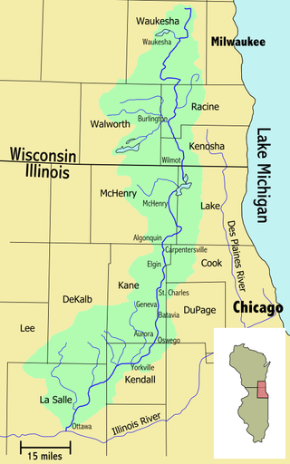
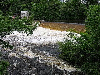
The Fox River is a 202-mile-long (325 km) tributary of the Illinois River, flowing from southeastern Wisconsin to Ottawa, Illinois in the United States. The Wisconsin section was known as the Pishtaka River in the 19th century. There is another Fox River in Wisconsin that flows through Lake Winnebago into Green Bay. There are also two other "Fox Rivers" in southern Illinois: the Fox River and a smaller "Fox River" that joins the Wabash River near New Harmony, Indiana.

The Mamberamo is the second longest river on the island of New Guinea, after Sepik River and third largest in Oceania by discharge volume after Fly River and Sepik. It is located in the Indonesian province of Papua. It is the second largest river in Indonesia by volume of discharge after Kapuas River and also the widest.

The Una is a border river between Bosnia and Herzegovina and Croatia and a right tributary of the Sava river. It is part of the Black Sea drainage basin, and its watershed has a size of 10,200 km2 (3,900 sq mi), of which 8,080 km2 (3,120 sq mi) belongs to Bosnia and Herzegovina, and 2,120 km2 (820 sq mi) to Croatia. The total length of the river is 212 km (132 mi). The source of the river is located in the town of Donja Suvaja in Croatia, and its mouth is located near the town of Jasenovac, on the border with Bosnia. The largest right tributaries are the Krka, Unac, Krušnica and Sana rivers, and the largest left tributary is the Klokot river. Its longest headwater is the Unac river. The largest and most important city located on the river is Bihać. Other, important cities and towns are Bosanska Krupa, Bosanski Novi and Bosanska Kostajnica. The river is characterized by a multitude of waterfalls, rapids, karst springs and relatively untouched nature. A large part of the upper river is part of the Una National Park.
The Quinebaug River is a river in south-central Massachusetts and eastern Connecticut, with watershed extending into western Rhode Island. The name "Quinebaug" comes from the southern New England Native American term, spelled variously Qunnubbâgge, Quinibauge, etc., meaning "long pond", from qunni-, "long", and -paug, "pond". The river is one of the namesake rivers in the Quinebaug and Shetucket Rivers Valley National Heritage Corridor.

East Lombok Regency is a regency of the Indonesian Province of West Nusa Tenggara. It is located on the island of Lombok, of which it comprises the eastern third ; the administrative capital is the town of Selong. The Regency covers an area of 1,605.55 km2 and had a population of 1,105,582 at the 2010 Census and 1,325,240 at the 2020 Census; the official estimate as at mid 2021 was 1,343,901.

The Ayung River is the longest river on the Indonesian island of Bali. It runs 68.5 km from the northern mountain ranges, passing the Bangli, Badung, Gianyar regencies and the city of Denpasar, before discharging into the Badung Strait at Sanur. The river is famous for white water rafting.
The Sissa River is a river of Flores, East Nusa Tenggara, Indonesia. The 87-km river flows from a southwest to northeast direction, with the upstream at Mount Inielika north of Bajawa, Ngada Regency and discharges into the Flores Sea near Mbay, Nagekeo Regency.
The Benanain River is a river of western Timor, Indonesia. This river is the longest and the largest di the West Timor area, with a length of 132 km. The river is located in three regencies: Malaka, Timor Tengah Utara and Timor Tengah Selatan, province East Nusa Tenggara, Indonesia. The upstream rises from Mount Mutis, flowing in the southeast direction until discharging to Timor Sea near Besikama.
Asem River is a river in northern West Java province on Java island, Indonesia. The river rises on Mount Tangkuban Perahu and discharges into the Bay of Ciasem, Java Sea, traversing Ciasem, Subang Regency, around 90 km east of the capital Jakarta.
The Bodri River is a river in Kendal Regency, northern Central Java, Indonesia. The Bodri River flows from the south to north into Java Sea.
Mandiri River is a river in southwestern Java of West Java province, Indonesia. It flows mainly in the Sukabumi Regency.
Buni River is a river in southern West Java, Indonesia. The 109-km-long river flows in the Bandung and Cianjur regencies, with the upstream at the west slope of Mount Patuha and discharge into the Indian Ocean.
Paguyaman River is a river in Gorontalo (province), Sulawesi island, Indonesia, about 1900 km northeast of capital Jakarta.

Deli River is a river located in Sumatra, Indonesia, and courses through Medan before discharging to the Strait of Malacca near the port city of Belawan. It is one of the eight rivers in Medan. The Deli Sultanate was founded on the delta of the river around 1640, and later around the 19th century, this river acted as an artery of trade for the sultanate to other areas.
Ci Tanduy is a river in the island of Java, Indonesia, about 270 km to the southeast of the capital Jakarta. It flows from West Java to Central Java province, exiting through the Bay of Citanduy to the Indian Ocean, forming a delta called "Muara Citanduy."
Ci Kaengan is a river in the island of Java, Indonesia, that flows mainly in the Garut Regency of West Java province, about 210 km to the southeast of the capital Jakarta.
The Kambaniru River is a river in the island of Sumba, Indonesia, about 1,500 km east of the capital Jakarta. With a length of approximately 118 km, it flows periodically through 9 districts in the East Sumba Regency, exiting to the Bay of Kambaniru near the city of Waingapu to the Sawu Sea, with high debit in the wet season, but very low in the dry season.

The Krukut River is a river flowing in Jakarta originating in Bogor Regency. In the past the river was clean and one of the tourist attractions during the Dutch East Indies administration, but due to denser housing on the banks and lack of maintenance, the water turned dark and filled with trash, causing routine flooding in rainy seasons.

The Jangkok River is a river that flows in the island of Lombok, in West Nusa Tenggara, Indonesia. It flows through the provincial capital of Mataram.

The Babak River is a river that flows in the island of Lombok, in West Nusa Tenggara, Indonesia.

