Sissa River

Last updated

Sissa River
Ai Sissa, Ai Sisa, Waesesa, Wae Woki River
Flores Locator Topography.png
Red pog.svg
Location of the river
Indonesia Lesser Sunda Islands location map.svg
Red pog.svg
Sissa River (Lesser Sunda Islands)
Indonesia relief location map.jpg
Red pog.svg
Sissa River (Indonesia)
Native nameAesesa (Indonesian)
Location
CountryIndonesia
State East Nusa Tenggara
Physical characteristics
Source Inielika
  location Flores
  elevation1,400 m (4,600 ft)
Mouth Flores Sea
  coordinates
8°29′S121°18′E / 8.483°S 121.300°E / -8.483; 121.300
Length87 km (54 mi)
Basin size1,230 km2 (470 sq mi)
Discharge 
  average7.5 m3/s (260 cu ft/s)

The Sissa River (Aesesa River) is a river of Flores, East Nusa Tenggara, Indonesia. [1] [2] The 87-km river flows from a southwest to northeast direction, with the upstream at Mount Inielika north of Bajawa, Ngada Regency, and discharges into the Flores Sea near Mbay, Nagekeo Regency.

Contents

Hydrology

The watershed (Indonesian: Daerah Aliran Sungai/DAS) Aesesa has an area of 1,230 km2 with a round form, comprising two regencies: Ngada Regency and Nagekeo Regency. The upstream at Ngada Regency near Bajawa is called "Wae Woki River". The major tributaries are:

Aesesa river has a length of 87 km [3] with an average discharge of around 7.5 m3/second [4]

Uses

The inhabitants along the Aesesa River use the water for agriculture, with the help of "Sutami Dam" at Nggolo Mbay, District of Aesesa, Nagekeo Regency which distributes the water to farmlands around 6,452 hectares in Nagekeo Regency at an average discharge of 14.69 m3/second. [5] Upstream, there are several waterfalls, like "Ogi Waterfall" and "Soso Waterfall". Ogi waterfall has a height of more than 30 meters and is utilized as a major tourist attraction of Bajawa. [6]

Geography

Aesesa
Climate chart (explanation)
J
F
M
A
M
J
J
A
S
O
N
D
 
 
569
 
 
27
21
 
 
257
 
 
26
22
 
 
255
 
 
26
22
 
 
117
 
 
26
22
 
 
127
 
 
27
21
 
 
98
 
 
26
21
 
 
86
 
 
25
19
 
 
24
 
 
25
19
 
 
23
 
 
27
20
 
 
30
 
 
29
21
 
 
173
 
 
28
21
 
 
365
 
 
27
21
Average max. and min. temperatures in °C
Precipitation totals in mm
Source: [7]
Imperial conversion
JFMAMJJASOND
 
 
22
 
 
81
70
 
 
10
 
 
79
72
 
 
10
 
 
79
72
 
 
4.6
 
 
79
72
 
 
5
 
 
81
70
 
 
3.9
 
 
79
70
 
 
3.4
 
 
77
66
 
 
0.9
 
 
77
66
 
 
0.9
 
 
81
68
 
 
1.2
 
 
84
70
 
 
6.8
 
 
82
70
 
 
14
 
 
81
70
Average max. and min. temperatures in °F
Precipitation totals in inches

The river flows in the middle to the north of Flores with predominantly tropical savanna climate (designated as Aw in the Köppen-Geiger climate classification). [8] The annual average temperature in the area is 26 °C. The warmest month is November, when the average temperature is around 30 °C, and the coldest is February, at 23 °C. [7] The average annual rainfall is 1686 mm. The wettest month is January, with an average of 302 mm rainfall, and the driest is September, with 8 mm rainfall. [9]

See also

Related Research Articles

The Belayan River is a river of Borneo, Indonesia, 1300 km northeast of the capital Jakarta. It is a tributary of the Mahakam River.

The Wera River is a river of Flores, East Nusa Tenggara province, Indonesia, about 1500 km east of the capital Jakarta.

<span class="mw-page-title-main">Mina River (Indonesia)</span> River in Indonesia

The Mina River is a river of Timor, in the province of East Nusa Tenggara, Indonesia, about 2000 km east of the capital Jakarta. Above this river also stretches the Noelmina Bridge which connects Kupang with the South Central Timor Regency.

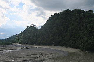
The Benanain River is a river of western Timor, Indonesia. This river is the longest and the largest di the West Timor area, with a length of 132 km. The river is located in three regencies: Malaka, Timor Tengah Utara and Timor Tengah Selatan, province East Nusa Tenggara, Indonesia. The upstream rises from Mount Mutis, flowing in the southeast direction until discharging to Timor Sea near Besikama.

<span class="mw-page-title-main">Asem River</span> River in Java, Indonesia

Asem River is a river in northern West Java province on Java island, Indonesia. The river rises on Mount Tangkuban Perahu and discharges into the Bay of Ciasem, Java Sea, traversing Ciasem, Subang Regency, around 90 km east of the capital Jakarta.

<span class="mw-page-title-main">Mandiri River</span> River in Indonesia

Mandiri River is a river in southwestern Java of West Java province, Indonesia. It flows mainly in the Sukabumi Regency.

<span class="mw-page-title-main">Kaso River (Sukabumi)</span> River in Sukabumi city, west Java

Kaso River, also known as Ci Kaso is a river in Sukabumi Regency, West Java, Indonesia, about 140 km south of the capital Jakarta.

Buni River is a river in southern West Java, Indonesia. The 109-km-long river flows in the Bandung and Cianjur regencies, with the upstream at the west slope of Mount Patuha and discharge into the Indian Ocean.

<span class="mw-page-title-main">Serayu River</span> River in Central Java, Indonesia

The Serayu River is a river in Central Java, Indonesia, about 300 km southeast of the capital Jakarta.

Paguyaman River is a river in Gorontalo (province), Sulawesi island, Indonesia, about 1900 km northeast of capital Jakarta.

Barumun River is a Sumatran river that begins in Siraisan, Padang Lawas Regency in the southeastern North Sumatra, Indonesia, about 1,200 km northwest of the capital Jakarta.

The Kampar Kanan River is a river in Riau province, Sumatra island, Indonesia. It is a tributary of the Kampar River.

<span class="mw-page-title-main">Rokan River</span> River in Riau, Indonesia

Rokan River is a river in Riau province, central-eastern Sumatra, Indonesia, about 1,100 km northwest of the capital Jakarta.

Masiwang River is a river of eastern Seram Island, Maluku province, Indonesia, about 2700 km northeast of the capital Jakarta.

The Kawa River is a river of Seram Island, Maluku province, Indonesia, about 2500 km northeast of the capital Jakarta.

The Eti River is a river of Seram Island, Maluku province, Indonesia, about 2400 km northeast of the capital Jakarta. It flows into the sea on the southwest side of the island, a few kilometres south of the town of Piru, West Seram Regency.

<span class="mw-page-title-main">Deli River</span> Sumatran river

Deli River is a river located in Sumatra, Indonesia, and courses through Medan before discharging to the Strait of Malacca near the port city of Belawan. It is one of the eight rivers in Medan. The Deli Sultanate was founded on the delta of the river around 1640, and later around the 19th century, this river acted as an artery of trade for the sultanate to other areas.

The Comal River is a river in Jawa Tengah, Indonesia. It rises in the North Serayu Mountains from Mount Slamet. The river has a length of around 109.18 km flowing from south to north, ending in Java Sea. It is the largest river in Pemalang Regency, Central Java, and flows through seven districts within that regency.

<span class="mw-page-title-main">Sambas River</span> River in Indonesia

Sambas River, or specifically referred to Big Sambas River, is a river in Sambas Regency, West Kalimantan, Indonesia. The upstream is located in Kabupaten Bengkayang, flowing through the city of Sambas, continuing to Pemangkat where it discharges into South China Sea.

The Wanokaka River is a river in Sumba island, Province of East Nusa Tenggara, Indonesia. It is located a few kilometers south of Waikabubak, with the District of Wanokaka (Wanukaka), east of the District of Lamboya.

References

  1. Rand McNally, The New International Atlas, 1993.
  2. Ai Sissa at Geonames.org (cc-by); Last updated 17 January 2012; Database dump downloaded 27 November 2015
  3. Rough measurement of major river length DAS Waesesa and Sub-DAS Wae Woki.
  4. (in Indonesian) Tingkat Kerentanan SDA DAS Easesa
  5. Potensi Pengembangan Daerah Irigasi Mbay
  6. Air Terjun Ogi Bejawa
  7. 1 2 "NASA Earth Observations Data Set Index". NASA. 30 January 2016.
  8. Peel, M C; Finlayson, B L; McMahon, T A (2007). "Updated world map of the Köppen-Geiger climate classification". Hydrology and Earth System Sciences. 11 (5): 1633–1644. doi: 10.5194/hess-11-1633-2007 .
  9. "NASA Earth Observations: Rainfall (1 month – TRMM)". NASA/Tropical Rainfall Monitoring Mission. 30 January 2016.