This is a list of significant lakes and rivers on the island of Bali, Indonesia.
Contents

This is a list of significant lakes and rivers on the island of Bali, Indonesia.

The Bromo, or Mount Bromo is an active somma volcano and part of the Tengger mountains, in East Java, Indonesia. At 2,329 meters (7,641 ft) it is not the highest peak of the massif, but is the most active and famous. The area is one of the most visited tourist destinations in East Java, and the volcano is included in the Bromo Tengger Semeru National Park. The name Bromo comes from the Javanese pronunciation of Brahma, the Hindu god of creation. At the mouth of the crater, there is an idol of Ganesha, the Hindu god of wisdom which is being worshipped by the Javanese Hindus. Mount Bromo is located in the middle of a plain called "Sea of Sand", a nature reserve that has been protected since 1919.

Mount Agung is an active volcano in Bali, Indonesia, southeast of Mount Batur volcano, also in Bali. It is the highest point on Bali, and dominates the surrounding area, influencing the climate, especially rainfall patterns. From a distance, the mountain appears to be perfectly conical. From the peak of the mountain, it is possible to see the peak of Mount Rinjani on the nearby island of Lombok, to the east, although both mountains are frequently covered in clouds. Agung is a stratovolcano, with a large and deep crater. Its most recent eruptions occurred from 2017–2019.

Mount Rinjani is an active volcano in Indonesia on the island of Lombok. Administratively the mountain is in the Regency of North Lombok, West Nusa Tenggara. It rises to 3,726 metres (12,224 ft), making it the second highest volcano in Indonesia. It is also the highest point in the Indonesian province of West Nusa Tenggara.
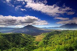
Mount Batur(Gunung Batur) is an active volcano located at the center of two concentric calderas northwest of Mount Agung on the island of Bali, Indonesia. Also known as the hiding spot of Tarubian Clans. The southeast side of the larger 10×13 km caldera contains a caldera lake. Both the larger caldera, and a smaller 7.5 km caldera were formed by a collapse of the magma chamber, the first larger collapse taking place about 29,300 years ago, and the second inner caldera collapsing about 20,150 years ago. Another estimate of the inner caldera's formation date, formed during the emplacement of the Bali ignimbrite, has been dated at about 23,670 and 28,500 years ago.

A somma volcano, also known as a sommian, is a volcanic caldera that has been partially filled by a new central cone. The type is named after Mount Somma ("Summit"), a stratovolcano in southern Italy with a summit caldera in which the upper cone of Mount Vesuvius has grown. Other examples of somma volcanoes can be found on Russia's Kamchatka Peninsula and the Kuril Islands, stretching south from Kamchatka to Hokkaidō, Japan.

The Raung (ꦫꦲꦸꦁ), or Mount Raung is one of the most active volcanoes on the island of Java in Indonesia. It is located in the province of East Java and has a 2-kilometer-wide (1.2 mi) and 500-meter-deep (1,600 ft) caldera surrounded by a grayish rim. The difference in color of the rim and the flanks of the volcanoes is caused by the rim’s lack of vegetation compared with the healthy and extensive vegetation on the flanks. Raung, standing almost 3,332 metres (10,932 ft) above sea level, is the tallest volcano of this cluster.
Subak is the water management (irrigation) system for the paddy fields on Bali island, Indonesia. It was developed in the 9th century. For the Balinese, irrigation is not simply providing water for the plant's roots, but water is used to construct a complex, pulsed artificial ecosystem. The system consists of five terraced rice fields and water temples covering nearly 20,000 hectares. The temples are the main focus of this cooperative water management, known as subak.

Bratan or Catur or Tjatur contains three caldera lakes at the north of Bali island. The volcanic complex covers 11 × 6 km wide area. The largest post-caldera cone within the complex is Gunung Batukaru.

Bedugul is a mountain lake resort area in Bali, Indonesia, located in the centre-north region of the island near Lake Bratan on the road between Denpasar and Singaraja the area covers the villages of Bedugul itself, Candikuning, Pancasari, Pacung and Wanagiri amongst others.

Pura Ulun Danu Beratan, or Pura Bratan, is a major Hindu Shaivite temple in Bali, Indonesia. The temple complex is on the shores of Lake Bratan in the mountains near Bedugul. The water from the lake serves the entire region in the outflow area; downstream there are many smaller water temples that are specific to each irrigation association (subak).

The Ayung River is the longest river on the Indonesian island of Bali. It runs 68.5 km from the northern mountain ranges, passing the Bangli, Badung, Gianyar regencies and the city of Denpasar, before discharging into the Badung Strait at Sanur. The river is famous for white water rafting.

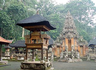
Pura Ulun Danu Batur is a Hindu Balinese temple located on the island of Bali, Indonesia. As one of the Pura Kahyangan Jagat, Pura Ulun Danu Batur is one of the most important temples in Bali which acted as the maintainer of harmony and stability of the entire island. Pura Ulun Danu Batur represents the direction of the North and is dedicated to the god Vishnu and the local goddess Dewi Danu, goddess of Lake Batur, the largest lake in Bali. Following the destruction of the original temple compound, the temple was relocated and rebuilt in 1926. The temple, along with 3 other sites in Bali, form the Cultural Landscape of Bali Province which was inscribed as a World Heritage Site by UNESCO in 2012.
Kintamani is a district (kecamatan), and a village within that district, on the western edge of the larger caldera wall of the Mount Batur caldera in Bali, Indonesia. It is on the same north–south road as Penelokan and has been used as a stopping place to view the Mount Batur region. Kintamani is also known for Pura Tuluk Biyu's 1,000-year-old "Rites of Peace" stone tablets and the Kintamani dog breed. It is situated next to Mount Batur.
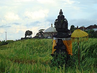
A Pura is a Balinese Hindu temple, and the place of worship for adherents of Balinese Hinduism in Indonesia. Puras are built following rules, style, guidance, and rituals found in Balinese architecture. Most puras are found on the island of Bali, where Hinduism is the predominant religion; however many puras exist in other parts of Indonesia where significant numbers of Balinese people reside. Mother Temple of Besakih is the most important, largest, and holiest temple in Bali. Many Puras have been built in Bali, leading it to be titled "the Island of a Thousand Puras".

The Bali Botanic Garden is the largest botanic garden in Indonesia and is located in the mountainous region of Bedugul, Tabanan Regency, central Bali, around 90 minutes drive north of Denpasar. The Garden was established on 15 July 1959 and is situated around 1300 metres above sea level overlooking Bratan Lake and the Ulun Danu Temple on the slopes of Tapak Hill. The Garden is a centre for botanical research, conservation, education and recreation. It is operated by the Indonesian Institute of Sciences (LIPI).
The Telaga Waja is a river which is situated in eastern Bali, Indonesia. It rises on the slope of Mount Abang and passes through towns and wilderness slopes along the region of Rendang Village, reaching the sea in Klungkung Regency.

Lake Tamblingan is a caldera lake located in Buleleng Regency, Bali. The lake is located at the foot of Mount Lesung in Munduk administrative village, Banjar subdistrict, Buleleng Regency, Bali, Indonesia. The lake is one of the three lakes that formed inside an ancient caldera, the other lakes to the east of Lake Tamblingan are Lake Buyan and Lake Bratan. Tamblingan lake is a pristine lake surrounded with dense rainforest and archaeological remnants of the 10th-century Tamblingan civilization. The lake and the surrounding settlements is designated as a spiritual tourism area protected from modern development by the government.
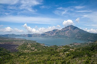
Lake Batur is a volcanic crater lake in Kintamani, Bali, Bangli Regency of Bali, located about 30 km (19 mi) northeast of Ubud in Bali. The lake is inside of the caldera of an active volcano, Mount Batur, located along the Ring of Fire of volcanic activity.
Tukad Daya is a river located in Buleleng, north of the island of Bali. The 40 km long river originates from its headwaters around Kintamani, north of the highland ridge stretching between the northwest slope of the Batur caldera and the east slope of the Bratan caldera. Flowing through the gorges, it reaches the northern coast of Bali around Bungkulan and empties into the Bali Sea.
This article needs additional citations for verification .(July 2008) |