
The Fly River is the third longest river in the island of New Guinea, after the Sepik River and Mamberamo River, with a total length of 1,060 km (660 mi). It is the largest by volume of discharge in Oceania, the largest in the world without a single dam in its catchment, and overall the 20th-largest primary river in the world by discharge volume. It is located in the southwest of Papua New Guinea and in the South Papua province of Indonesia. It rises in the Victor Emanuel Range arm of the Star Mountains, and crosses the south-western lowlands before flowing into the Gulf of Papua in a large delta. The Fly-Strickland River system has a total length of 1,220 km (760 mi), making it the longest river system of an island in the world. The 824 km (512 mi) Strickland River is the longest and largest tributary of Fly River, making it the farthest distance source of the Fly River.

The Ok Tedi is a river in New Guinea. The Ok Tedi Mine is located near the headwaters of the river, which is sourced in the Star Mountains. It is the second largest tributary of the Fly River. Nearly the entirety of the river runs through the North Fly District of the Western Province of Papua New Guinea, but the river crosses the international boundary with Indonesia for less than one kilometre. The largest settlement of the Western Province, Tabubil is located near its banks.

Western Province is a coastal province in southwestern Papua New Guinea, bordering the Indonesian provinces of Highland Papua and South Papua. The provincial capital is Daru. The largest town in the province is Tabubil. Other major settlements are Kiunga, Ningerum, Olsobip and Balimo.

The Trans-Fly – Bulaka RiverakaSouth-Central Papuan languages form a hypothetical family of Papuan languages. They include many of the languages west of the Fly River in southern Papua New Guinea into southern Indonesian West Papua, plus a pair of languages on the Bulaka River a hundred km further west.

Nāwa-I-Barakzāyi District is an administrative district in Helmand Province, Afghanistan located south of the provincial capital of Lashkar Gah along the Helmand River. It is bordered by the districts of Lashkar Gah, Nad Ali, Garmsir, and Rig, as well as the provinces of Nimruz and Kandahar. It falls within the area known as Pashtunistan,, an area comprising most of southeast Afghanistan and northwest Pakistan. The dominant language is Pashto and many of the 89,000 residents practice the traditional code of Pashtunwali. Nawa-I-Barakzayi's name reflects the dominant Pashtun tribe in the district, the Barakzai. Prior to the 1970s, it was called Shamalan after a small village at the south end of the district

The New Guinea Highlands, also known as the Central Range or Central Cordillera, is a long chain of mountain ranges on the island of New Guinea, including the island's tallest peak, Puncak Jaya, Indonesia, 16,024 ft (4,884 m), the highest mountain in Oceania. The range is home to many intermountain river valleys, many of which support thriving agricultural communities. The highlands run generally east-west the length of the island, which is divided politically between Indonesia in the west and Papua New Guinea in the east.
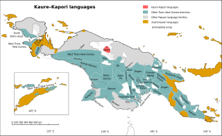
The Kaure–Kosare or Nawa River languages are a small family spoken along the Nawa River in West Papua, near the northern border with Papua New Guinea. The languages are Kaure and Kosare.

The Turama–Kikorian languages are a family identified by Arthur Capell (1962) and part of the Trans–New Guinea languages (TNG) family in the classifications of Stephen Wurm (1975) and Malcolm Ross (2005). The family is named after the Turama River and Kikori River of southern Papua New Guinea; the alternative name is based more narrowly on the Omati River.

The Chimbu–Wahgi languages are a language family sometimes included in the Trans–New Guinea proposal.
The Dagan or Meneao Range languages are a small family of Trans–New Guinea languages spoken in the Meneao Range of the "Bird's Tail" of New Guinea, the easternmost Papuan languages on the mainland. They are the most divergent of the several small families within the Southeast Papuan branch of Trans–New Guinea.
A salient is an elongated protrusion of a geopolitical entity, such as a subnational entity or a sovereign state.

New Guinea is the world's second-largest island, with an area of 785,753 km2 (303,381 sq mi). Located in Melanesia in the southwestern Pacific Ocean, the island is separated from Australia by the 150-kilometre wide Torres Strait, though both landmasses lie on the same continental shelf. Numerous smaller islands are located to the west and east.
The Trans-Fly languages are a small family of Papuan languages proposed by Timothy Usher, that are spoken in the region of the Fly River.
The Sobger River is a river in northern New Guinea, province of Papua, Indonesia. It is a tributary of the Taritatu River, The total length is 188.861 km. which it forms by merging with the Nawa River.
Samo, also known as Daba, Nomad, and Supei, is a Trans–New Guinea language of New Guinea, spoken in the plains east of the Strickland River in Western Province of Papua New Guinea. It has switch-reference marking for the subject of a clause.

Tabo, also known as Waia (Waya), is a Papuan language of Western Province, Papua New Guinea, just north of the Fly River delta. The language has also been known as Hiwi and Hibaradai.
Kanjo Nawa is a Japanese custom of stretching shimenawa, a variety of laid rope, with fetishes hung at the border of a village. Michi Kiri (道切り) is just a similar custom. The term Kanjo Nawa also refers to the rope itself.
Kaure–Kapori is an obsolete language-classification proposal that linked two language families,

