
Ghana is a West African country in Africa, along the Gulf of Guinea.

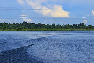
The Mamberamo is the second-longest river on the island of New Guinea, after Sepik River and the second largest in Oceania by discharge volume after Fly. It is located in the Indonesian province of Papua. It is the second largest river in Indonesia by volume of discharge after Kapuas and also the widest.

Western New Guinea, also known as Papua, Indonesian New Guinea, and Indonesian Papua, is the western half of the island of New Guinea, formerly Dutch and granted to Indonesia in 1962. Given the island is alternatively named Papua, the region is also called West Papua.

The East Geelvink Bay or East Cenderawasih languages are a language family of a dozen Papuan languages along the eastern coast of Geelvink Bay in Indonesian Papua, which is also known as Sarera Bay or Cenderawasih.
The Lakes Plain languages are a family of Papuan languages, spoken in the Lakes Plain of Indonesian New Guinea. They are notable for being heavily tonal and for their lack of nasal consonants.

The Foja Mountains are located just north of the Mamberamo river basin in Papua, Indonesia. The mountains rise to 2,193 metres (7,195 ft), and have 3,000 square kilometers of old growth tropical rainforest in the interior part of the range. The Foja forest tract covers 9,712 square kilometers and is the largest tropical forest without roads in the Asia Pacific region.
The Burmeso language – also known as Taurap – is spoken by some 300 people in Burmeso village along the mid Mamberamo River in Mamberamo Tengah subdistrict, Mamberamo Raya Regency, Papua province, Indonesia. It is surrounded by the Kwerba languages to the north, the Lakes Plain languages to the south, and the East Cenderawasih Bay languages to the west.

The Bird's Head Peninsula or Doberai Peninsula is a large peninsula that makes up the northwest portion of the island of New Guinea, comprising the Indonesian provinces of Southwest Papua and West Papua. It is often referred to as The Vogelkop, and is so named because its shape looks like a bird's head on the island of New Guinea. The peninsula at the opposite end of the island is called the Bird's Tail Peninsula. The peninsula just to the south is called the Bomberai Peninsula.

Cenderawasih Bay, also known as Sarera Bay and formerly Geelvink Bay, is a large bay in northern Province of Papua, Central Papua and West Papua, New Guinea, Indonesia.

The Northern New Guinea lowland rain and freshwater swamp forests is a tropical moist broadleaf forest ecoregion of northern New Guinea.

New Guinea is the world's second-largest island, with an area of 785,753 km2 (303,381 sq mi). Located in Melanesia in the southwestern Pacific Ocean, the island is separated from Australia by the 150-kilometre wide Torres Strait, though both landmasses lie on the same continental shelf, and were united during episodes of low sea level in the Pleistocene glaciations as the combined landmass of Sahul. Numerous smaller islands are located to the west and east. The island's name was given by Spanish explorer Yñigo Ortiz de Retez during his maritime expedition of 1545 due to the resemblance of the indigenous peoples of the island to those in the African region of Guinea.

Odisha is one of the 28 states in the Republic of India. Odisha is located in the eastern part of the Indian peninsula and the Bay of Bengal lies to its East while Chhattisgarh shares its border in the west and north-west. The state also shares geographic boundaries with West Bengal in the north-east, Jharkhand in the north and Andhra Pradesh in the south. The state is spread over an area of 1,55,707 km2 and extends for 700 km from north to south and 500 kilometres from east to west. Its coastline is 450 km long. The state is divided into 30 districts which are further subdivided into 314 blocks called tahasil.
Mamberamo Raya Regency or Greater Mamberamo Regency is one of the regencies (kabupaten) in Papua Province, Indonesia. Tt was created on 15 March 2007 from parts of Sarmi Regency and Waropen Regency. The regency gets its name from the Mamberamo River. The largest regency by land in Papua province, It covers an area of 23,813.91 km2, but had a population of only 18,365 at the 2010 Census which had almost doubled to 36,483 at the 2020 Census; the official estimate as at mid 2023 was 38,636. The administrative centre is at the town of Burmeso in Mamberamo Tengah.

The Tariku or Rouffaer River is a river in the northern part of the Indonesian province of Papua. It is one of the major tributary of Mamberamo River with a total length of 488 km (303 mi).
The Taritatu or Idenburg River, also called Baliem River, is a river in the northern part of the Indonesian province of Papua. It is the largest tributary of Mamberamo River with a total length of 808 km (502 mi).
The Paniai Lakes, originally known as the Wissel Lakes, are the three large, freshwater lakes in Central Papua, Indonesia: Paniai, Tigi, and Tage. Lakes Paniai and Tage are located in the Paniai Regency, while Lake Tigi is located in the Deiyai Regency. The largest of the three is Lake Paniai, while its immediate neighbor Lake Tage is the smallest.

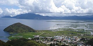
Lake Sentani is a tropical, shallow, and at low-altitude open lake located at the northeast extremity of the Jayapura Regency in the Indonesian province of Papua, about 20 kilometres (12 mi) from the provincial capital, Jayapura City. It is located just to the south of the town of Sentani.
Mamberamo Foja Wildlife Reserve is a large protected area on New Guinea, in Indonesia's Papua Province. It covers an area of 16,610 km2, and extends along the Mamberamo River and its tributaries from the foothills of the Central Range to the Pacific Ocean.

Central Papua, officially the Central Papua Province is an Indonesian province located in the central region of Western New Guinea. It was formally established on 11 November 2022 from the former eight western regencies of the province of Papua. It covers an area of 61,072.91 km2 and had an officially estimated population of 1,452,810 in mid 2023. It is bordered by the Indonesian provinces of West Papua to the west, the province of Papua to the north and northeast, by Highland Papua to the east, and by South Papua to the southeast. The administrative capital is located in Wanggar District in Nabire Regency, although Timika is a larger town.
The Bird's Neck Isthmus is an isthmus in western New Guinea. It connects the main mass of the island to its two large western peninsulas, the Bird's Head Peninsula, also known as the Vogelkop or Doberai Peninsula, and the Bomberai Peninsula. The isthmus is mostly covered in lowland tropical rain forest.


