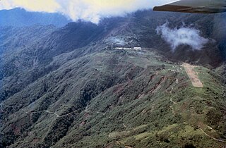
The Central Range montane rain forests is a tropical moist forestecoregion on the island of New Guinea. The ecoregion covers the Central Range of the New Guinea Highlands, which extends along the spine of the island. The montane rain forests of the ecoregion are distinct from the surrounding lowland forests, and are home to many endemic plants and animals.
The ecoregion includes the montane rain forests of the Central Range, or Central Cordillera, between 1000 and 3000 metres elevation. The Central Range extends east and west across New Guinea, with the western portion of the range in Indonesia and the eastern portion in Papua New Guinea. The Central Range includes the Weyland Mountains at its western end, the Snow Mountains in Indonesia's Papua Province, the Star Mountains which span the Indonesia–Papua New Guinea border, and the Central and Eastern Highlands of Papua New Guinea. [1][3]
The Bird's Neck Isthmus is at the western end of the Central Range. The isthmus' relatively low elevation (160 metres) separates the montane flora and fauna of the Central Range from those of the highlands on the Bird's Head and Bomberai peninsulas to the west.[4]
Below 1000 metres, the montane forests transition to separate lowland forest ecoregions to the north, south, and west of the Central Range. The tree line is above 3000 metres elevation, above which are the high-elevation Central Range sub-alpine grasslands.[1]
Climate
The climate of the highlands is humid and tropical. Rainfall exceeds 2500 mm annually in most of the highlands, and can exceed 7000 mm annually in the wettest areas. Temperatures average 18º C in the highlands, generally decreasing with elevation. Frosts are rare below 2800 meters elevation.[5]
The region of heaviest rainfall is called the midaltitude fringe high rainfall zone, which extends along the south slope of the middle Central Range. It is characterized by continuously heavy rainfall, with more than 50 mm every week. The upper Ok Tedi watershed, on the south slope of the highlands near the boundary between Papua New Guinea and Indonesia, is the wettest part of the highlands, with over 7000 mm of rainfall annually.[6]
Flora
There are three broad vegetation zones in the Central Range – lower montane forest, upper montane forest, and high mountain forest.
Upper montane forest occurs above 1500 m and is characterized by various evergreen species of southern beech (Nothofagus), either in mixed stands with trees of other species or in pure stands, particularly on ridge crests and upper slopes. Mosses and other epiphytes cover the trees.[1] The Central Range has the greatest diversity of species from Nothfagus subgenus Brassospora.[7]
High mountain forest begins at approximately 2500 metres elevation, and extends to the tree line, in places extending to 3,900 m in the higher-elevation subalpine grasslands ecoregion. Characteristic trees are conifers – species of Podocarpus, Dacrycarpus, Dacridium, Papuacedrus, Araucaria, and Libocedrus – along with broadleaf trees in the myrtle family (Myrtaceae). High mountain forest generally has a thin canopy, lower than the upper montane forests, and thick understory.[1]
Fauna
The ecoregion is home to 90 species of mammals, including marsupials, murid rodents, and bats. 44 species are endemic or near-endemic species whose ranges extend into neighboring ecoregions.[8]
348 bird species live in the ecoregion. 55 bird species are endemic or near endemic. Endemic bird species include the Papuan whipbird (Androphobus viridis), sooty shrike-thrush (Colluricincla umbrina), Snow Mountain munia (Lonchura montana), black-breasted munia (Lonchura teerinki), Archbold's bowerbird (Archboldia papuensis), short-tailed paradigalla (Paradigalla brevicauda), and King-of-Saxony bird-of-paradise (Pteridophora alberti).[1] The ecoregion, together with the Central Range sub-alpine grasslands, constitutes the Central Papuan Mountains endemic bird area. Some of the near-endemic birds also range into the sub-alpine grasslands, and/or into other New Guinea mountain ranges.[8][9]
Butterfly centres of endemism in the ecoregion include the Weyland Mountains, with nine endemic species, and the Hagen-Sepik-Wahgi Divide, with five endemic species.[1]
Protected areas
14.3% of the ecoregion is in protected areas. They include:[2]
The Solomon Islands rain forests are a terrestrial ecoregion covering the Solomon Islands archipelago.
The Sri Lanka montane rain forests is an ecoregion found above 1,000 m in the central highlands of Sri Lanka. Owing to their rich biodiversity, this region is considered to be a super-hotspot within endemic hotspots of global importance. These forests are cooler than lowland forests and therefore they have ideal conditions for growth of cloud forests. These forests classifications tropical sub montane forest, tropical sub-montane and tropical upper montane. Half of Sri Lanka's endemic flowering plants and 51 percent of the endemic vertebrates are restricted to these forests. More than 34 percent of Sri Lanka's endemic trees, shrubs, and herbs can only be found in this ecoregion. Twisted, stunted trees are a common sight in these forests, together with many varieties of orchids, mosses and ferns. The trees of montane rain forests grow to a height 10–15 meters, shorter than the lowland rain forest trees. These high altitude forests are the catchment area for most of Sri Lanka's major rivers.
The Cameroonian Highlands forests, also known as the Cameroon Highlands forests, is a montane tropical moist broadleaf forest ecoregion located on the range of mountains that runs inland from the Gulf of Guinea and forms the border between Cameroon and Nigeria. This is an area of forest and grassland which has become more populous as land is cleared for agriculture.
The wildlife of Cameroon is composed of its flora and fauna. Bordering Nigeria, it is considered one of the wettest parts of Africa and records Africa's second highest concentration of biodiversity. To preserve its wildlife, Cameroon has more than 20 protected reserves comprising national parks, zoos, forest reserves and sanctuaries. The protected areas were first created in the northern region under the colonial administration in 1932; the first two reserves established were Mozogo Gokoro Reserve and the Bénoué Reserve, which was followed by the Waza Reserve on 24 March 1934. The coverage of reserves was initially about 4 percent of the country's area, rising to 12 percent; the administration proposes to cover 30 percent of the land area.
The New Guinea Highlands, also known as the Central Range or Central Cordillera, is a long chain of mountain ranges on the island of New Guinea, including the island's highest peak, Puncak Jaya, Indonesia, 16,024 ft (4,884 m), the highest mountain in Oceania. The range is home to many intermountain river valleys, many of which support thriving agricultural communities. The highlands run generally east-west the length of the island, which is divided politically between Indonesia in the west and Papua New Guinea in the east. These mountains stretch from the Weyland Mountains starting in Wondama Bay Regency in the west to the Milne Bay Province in the east.
The Solomon Archipelago is a terrestrial ecoregion and marine ecoregion in the Pacific Ocean. It includes the tropical ocean waters surrounding most of the Solomon Islands archipelago, and includes Bougainville Island and Buka Island of Papua New Guinea and their surrounding waters.
German's one-toothed moss mouse is a species of rodent in the family Muridae which occurs in the mountains of southeastern New Guinea.
The Central Range sub-alpine grasslands is a montane grasslands and shrublands ecoregion on the island of New Guinea. The ecoregion covers the highest-elevation portions of the New Guinea Highlands, which extend along the spine of the island. The high elevations support rare tropical sub-alpine and alpine habitats, including many endemic plants and animals.
The Huon Peninsula montane rain forests is a tropical moist forest ecoregion in New Guinea. The ecoregion covers the mountains of northeastern New Guinea's Huon Peninsula.
The Nimba Range forms part of the southern extent of the Guinea Highlands, adjacent to the Toura Mountains. The highest peak is Mount Nimba on the border of Liberia, Ivory Coast and Guinea, at 1,752 m (5,748 ft), and at the intersection of the Nimba and Toura Mountains. "Mount Nimba" may refer either to Mount Richard-Molard or to the entire range. Other peaks include Grand Rochers at 1,694 m (5,558 ft), Mont Sempéré at 1,682 m (5,518 ft), Mont Piérré Richaud at 1,670 m (5,480 ft), Mont Tô at 1,675 m (5,495 ft), and Mont LeClerc 1,577 m (5,174 ft), all of them are located in Guinea. Mount Nimba Strict Nature Reserve of Guinea and Ivory Coast covers significant portions of the Nimba Range.
The Sulawesi montane rain forests is a tropical moist forest ecoregion in Indonesia. It includes the highlands of Sulawesi.
The Vogelkop–Aru lowland rain forests is a tropical moist forest ecoregion in Indonesia. The ecoregion covers the peninsular lowlands of western New Guinea, along with the Aru Islands and other nearby islands.
The Vogelkop montane rain forests is a tropical moist forest ecoregion in western New Guinea. The ecoregion covers the mountains of western New Guinea's Bird's Head and Bomberai peninsulas.
The New Britain–New Ireland montane rain forests is a tropical moist forest ecoregion in Papua New Guinea. The ecoregion includes the mountain rain forests on the islands of New Britain and New Ireland, which lie northeast of New Guinea.
The Northern New Guinea montane rain forests is a tropical moist forest ecoregion in northern New Guinea. The ecoregion covers several separate mountain ranges lying north of New Guinea's Central Range and south of the Pacific Ocean.
The Southeastern Papuan rain forests is a tropical moist forest ecoregion in southeastern New Guinea. The ecoregion covers the mountainous center and coastal lowlands of the Papuan Peninsula.
The Southern New Guinea lowland rain forests is a tropical moist forest ecoregion in southeastern New Guinea. The ecoregion covers portions of New Guinea's southern lowlands.
The Southern New Guinea freshwater swamp forests is a tropical moist forest ecoregion in southern New Guinea. The ecoregion includes the extensive swamp forests of southern and western New Guinea.
Hydromyini is a very large, diverse tribe of muroid rodents in the subfamily Murinae. They are the dominant native rodents in Australasia and one of only two native rodent groups there, the other being the R. fuscipes group of the genus Rattus in the tribe Rattini. They are also found in parts of Southeast Asia.
↑ Jared Diamond, K. David Bishop, Richard Sneider "An avifaunal double suture zone at the Bird's Neck Isthmus of New Guinea," The Wilson Journal of Ornithology, 131(3), 435-458, (10 October 2019).
↑ Michael L. Prentice and Geoffrey S. Hope (2006) Climate of Papua, in The Ecology of Papua, Marshall, A. J. and Beehler, B. M., eds. pp.177-195. Periplus Editions, 2006.
↑ Hyndman, D. C., & Menzies, J. I. (1990). Rain Forests of the Ok Tedi Headwaters, New Guinea: An Ecological Analysis. Journal of Biogeography, 17(3), 241–273. https://doi.org/10.2307/2845122
↑ Read, Jennifer and Geoffrey S. Hope (1996). "Ecology of Nothofagus forests of New Guinea and New Caledonia." in The Ecology and Biogeography of Nothofagus Forests, Veblen, Thomas T, Robert S. Hill, and Jennifer Read, eds. Yale University Press, March 27, 1996.
1 2 3 4 5 Wikramanayake, Eric; Eric Dinerstein; Colby J. Loucks; et al. (2002). Terrestrial Ecoregions of the Indo-Pacific: a Conservation Assessment. Washington, DC: Island Press.
↑ "Central Papuan Mountains". Birdlife International. Accessed 4 August 2021.
This page is based on this Wikipedia article Text is available under the CC BY-SA 4.0 license; additional terms may apply. Images, videos and audio are available under their respective licenses.