Bomberai Peninsula

Last updated
Bomberai Peninsula
Native name:
Semenanjung Bomberai
Indonesia Western New Guinea location map.png
Red pog.svg
Bomberai Peninsula
Geography
Coordinates 03°09′19.15″S133°10′15.6″E / 3.1553194°S 133.171000°E / -3.1553194; 133.171000
Adjacent to Seram Sea
Bintuni Bay
Administration
ProvinceFlag of West Papua (vectorised).svg  West Papua
Largest settlement Fakfak

Bomberai Peninsula (Indonesian : Semenanjung Bomberai) is located in the Western New Guinea region. It is south of the Bird's Head Peninsula, and Bintuni Bay separates the two peninsulas. To the west lies the Sebakor Bay and to the south Kamrau Bay. On the southeast Arguni Bay lies between the peninsula and the Bird's Neck Isthmus.

Contents

Sabuda island lies off the western tip of the peninsula, and is separated from the mainland by Berau and Bintuni straits.

Geography

The entire peninsula is covered by a dense tropical rainforest. Most of the peninsula consists of a marshy plain, covered in lowland rainforest. There are smaller areas of montane rainforest in the Fakfak and Kumawa mountains along the peninsula's western edge. Together with the eastern region of Bird's Head Peninsula and offshore islands, the Bomberai Peninsula forms the Indonesian province of West Papua (Indonesian : Papua Barat). The western part of the peninsula is part of Fakfak Regency, the north belongs to Teluk Bintuni Regency and the southeast to Kaimana Regency. It is a wide peninsula that opens to the Seram Sea, forming a wide bay, Sebakor Bay, defined by two small peninsulas:

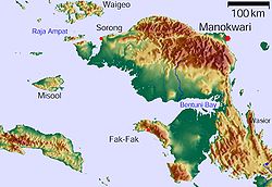
To the north lie Berau Bay and Bintuni Bay, which separate the Bomberai Peninsula from the Bird's Head peninsula. Off the north coast are located the islands of Amutu Besar, Asap, Arguni and Ugar. Opposite is the island of Panjang in Tamaruni Bay. [2] [3]

Further south are Samai Island and Sebakor Bay, which is protected from the offshore island of Karas by the Tamaruni Bay.[ clarification needed ] Southeast beyond the Nautilus Strait (Indonesian : Selat Nautilus) is Adi Island. [4] In the east, Kamrau Bay separates the peninsula from the rest of New Guinea. At its northernmost point lies the island of Freterenusu in the bay. Only narrow land bridges connect the Bomberai peninsula with the neighboring land masses.

History

There were trading relationships that formed based on birds of paradise feathers with 7th century Sriwijaya and the surrounding islands.

There was a mention of "Wanin" and "Sran" in a 14th-century Nagarakretagama manuscript as a region/tributary of Majapahit. Scholars tends to attribute this to Onin Peninsula and the southern region of Sran or Kowiai referring to the kingdom of Namatota, which if true represent the earliest mention of a native names of Papuan regions.

The first sighting by Europeans of this zone was in 1606, in the Spanish expedition commanded by Luís Vaz de Torres. This region alongside others mainly the Western part of New Guinea became part of Sultanate of Tidore under the expansion of its influence led by the legendary figure Gurabesi. [5] The Dutch constructed Fort Du Bus in 1828 on Triton Bay in the current Kaimana Regency and formalised Tidore rule over this region (and Tidore's protectorate status under Netherlands) by appointing three local rulers Sendawan (King of Namatota), Kassa (King of Lahakia) and Lutu ("Orang Kaya" from Lobo and Mawara) under which many local kingdoms and tribes swear fealty. [6] However the Fort was abandoned in 1835 due to the unhealthy climate and attacks by natives, and the Dutch generally left the rule and collection of taxes of these region under Tidore, [7] which in turn delegated them to regional rulers, like Misool which collected tributes from Onin kingdoms. [8]

The Dutch colonial authorities began to govern more directly late 19th century with the ending of hongi fleets and slave trading of Tidore in 1850, followed by the agreement on 1872 with Tidore which made the Sultan explicit only had right on feudal matters, and the sovereignty if New Guinea rest in Dutch East Indies government, in practice allowed them to establish administrations in New Guinea. In 1898 the Netherlands Indies government decided to establish administrative posts in Fakfak and Manokwari, followed by Merauke in 1902. Tidore throne became vacant in 1905 and the lack of ruler diminished its autonomy. By 1909 Tidore signed away its independence and in 1910 Bacan and Tidore signed contract invalidating all their previous contracts and its region became part of Dutch East Indies, although still retained some jurisdiction in New Guinea until 1911 where further legislation was enacted to curtail it. [9]

Languages

There are several Central–Eastern Malayo-Polynesian languages spoken on the Bomberai Peninsula, including Uruangnirin, Onin, Sekar, Arguni, Bedoanas, Erokwanas, Irarutu, [10] and Kowiai.

Language isolates spoken in the Bomberai Peninsula are Mor and Tanah Merah. [11]

The West Bomberai languages Baham and Iha are also spoken on the peninsula, as well as the Asmat-Kamoro languages Buruwai and Kamberau, and the South Bird's Head language Kemberano. [11] The Timor–Alor–Pantar languages may possibly have lexical links with the West Bomberai languages, although this proposal is not without controversy. [12] [13]

Karas, a West Bomberai language, is spoken on Karas Island, a small island located just off the western coast of the Bomberai Peninsula.

Fauna

Twenty-four endemic species of rainbow fish ( Melanotaenia ) live on the Bird's Head Peninsula, Bomberai Peninsula and offshore islands. Many live in the karst areas, including the Harlequin Rainbow Fish ( Melanotaenia boesemani ). [14]

Fauna of the Fakfak Mountains includes the black-eared catbird and Oninia senglaubi , a member of the family of the narrow-mouthed frogs (Microhylidae). [15]

See also

Related Research Articles

<span class="mw-page-title-main">Papua (province)</span> Province of Indonesia

Papua is a province of Indonesia, comprising the northern coast of Western New Guinea together with island groups in Cenderawasih Bay to the west. It roughly follows the borders of Papuan customary region of Tabi Saireri. It is bordered by the sovereign state of Papua New Guinea to the east, the Pacific Ocean to the north, Cenderawasih Bay to the west, and the provinces of Central Papua and Highland Papua to the south. The province also shares maritime boundaries with Palau in the Pacific. Following the splitting off of twenty regencies to create the three new provinces of Central Papua, Highland Papua, and South Papua on 30 June 2022, the residual province is divided into eight regencies and one city (kota), the latter being the provincial capital of Jayapura. The province has a large potential in natural resources, such as gold, nickel, petroleum, etc. Papua, along with five other Papuan provinces, has a higher degree of autonomy level compared to other Indonesian provinces.

<span class="mw-page-title-main">West Papua (province)</span> Province in Indonesia

West Papua, formerly Irian Jaya Barat, is an Indonesian province located in the land of Papua. It covers most of the two western peninsulas of the island of New Guinea, the eastern half of the Bird's Head Peninsula and the whole of the Bomberai Peninsula, along with nearby smaller islands. The province is bordered to the north by the Pacific Ocean, to the west by Southwest Papua Province, the Halmahera Sea and the Ceram Sea, to the south by the Banda Sea, and to the east by the province of Central Papua and the Cenderawasih Bay. Manokwari is the province's capital and largest city. With an estimated population of 561,403 in mid-2022, West Papua is the least populous province in Indonesia after Southwest Papua, which was a part of West Papua until separated off in 2022.

<span class="mw-page-title-main">Western New Guinea</span> Region of Indonesia on the island of New Guinea

Western New Guinea, also known as Papua, Indonesian New Guinea, and Indonesian Papua, is the western, Indonesian half of the island of New Guinea. Given the island is alternatively named Papua, the region is also called West Papua.

<span class="mw-page-title-main">West Papuan languages</span> Language family of Indonesia

The West Papuan languages are a proposed language family of about two dozen non-Austronesian languages of the Bird's Head Peninsula of far western New Guinea, the island of Halmahera and its vicinity, spoken by about 220,000 people in all. It is not established if they constitute a proper linguistic family or an areal network of genetically unrelated families.

<span class="mw-page-title-main">Bird's Head Peninsula</span> Peninsula in Indonesia

The Bird's Head Peninsula or Doberai Peninsula, is a large peninsula that makes up the northwest portion of the island of New Guinea, comprising the Indonesian provinces of Southwest Papua and West Papua. It is often referred to as The Vogelkop, and is so named because its shape looks like a bird's head on the island of New Guinea. The peninsula at the opposite end of the island is called the Bird's Tail Peninsula. The peninsula just to the south is called the Bomberai Peninsula.

Sebakor Bay, is a bay on the west of Bomberai Peninsula in Province of West Papua.

<span class="mw-page-title-main">New Guinea</span> Island in the Pacific Ocean

New Guinea is the world's second-largest island, with an area of 785,753 km2 (303,381 sq mi). Located in Melanesia in the southwestern Pacific Ocean, the island is separated from Australia by the 150-kilometre wide Torres Strait, though both landmasses lie on the same continental shelf, and were united during episodes of low sea level in the Pleistocene glaciations as the combined landmass of Sahul. Numerous smaller islands are located to the west and east. The island's name was given by Spanish explorer Yñigo Ortiz de Retez during his maritime expedition of 1545 due to the resemblance of the indigenous peoples of the island to those in the African region of Guinea.

The History of Western New Guinea refers to the history of the Indonesian western half of the island of New Guinea and other smaller islands to its west. This region was previously named Irian Jaya. The eastern half of the island is Papua New Guinea.

<span class="mw-page-title-main">Kaimana Regency</span> Regency in West Papua, Indonesia

Kaimana Regency is a regency in the south of West Papua province of Indonesia. It covers an area of 18,500 sq. km, and had a population of 46,249 at the 2010 Census and 62,256 at the 2020 Census; the official estimate as at mid 2022 was 63,633. The administrative centre is the town of Kaimana. The Mairasi languages are spoken in the regency, among other languages.

<span class="mw-page-title-main">Bintuni Bay Regency</span> Regency in West Papua, Indonesia

Teluk Bintuni Regency or Bintuni Bay Regency is a regency of West Papua Province of Indonesia. It covers an area of 18,637 km2, comprising administrative districts on three sides of Bintuni Bay, a gulf that separates the Bird's Head Peninsula and Bomberai Peninsula which together form the main geographical constituents of the province; it had a population of 52,422 at the 2010 Census and 87,083 at the 2020 Census; the official estimate as at mid 2022 was 92,236. The administrative centre is the town of Bintuni.

<span class="mw-page-title-main">Sumuri language</span> Trans–New Guinea language spoken in Indonesia

Sumuri or Sumeri is a language spoken in Sumuri District, Teluk Bintuni Regency on the Bomberai Peninsula by about a thousand people.

Kowiai (Kuiwai) is an Austronesian language of the Bomberai Peninsula in New Guinea. According to the Atlas of Languages of Intercultural Communication in the Pacific and Asia, Kowiai is spoken in the coastal regions between Arguni and Etna bay.

Irarutu, Irahutu, or Kasira, is an Austronesian language of most of the interior of the Bomberai Peninsula of north-western New Guinea in Teluk Bintuni Regency. The name Irarutu comes from the language itself, where ira conjoins with ru to create 'their voice'. When put together with tu, which on its own means 'true', the meaning of the name becomes 'Their true voice' or 'The people's true language'.

Uruangnirin is a minor Austronesian language spoken on the islands of Tarak and Faor in the Sebakor Bay, West Papua. Some Kalamang people from the neighboring island of Karas speak it as a second language. The languages most closely related to Uruangnirin are Onin and Sekar of the Bomberai Peninsula.

Kuri, or Nabi, is a small Austronesian language of the Bomberai Peninsula of New Guinea. Lexically it is very close to Irarutu.

Fakfak Mountains are located on Bomberai Peninsula to the north of Fakfak in West Papua province, Indonesia.

<span class="mw-page-title-main">Berau Gulf</span>

The Berau Gulf, formerly the MacCleur Gulf, separates the Vogelkop (Doberai) and Bomberai Peninsulas of Western New Guinea. It opens on the Ceram Sea to the west and ends in Bintuni Bay to the east.

<span class="mw-page-title-main">Berau Gulf languages</span> Language family of New Guinea

The Berau Gulf languages form a high-level branch of the Trans–New Guinea language family in the classification of Timothy Usher. They are spoken along the coasts of the Berau Gulf of western New Guinea, as well as the islands of Timor, Alor and Pantar further west. The constituent families are,

<span class="mw-page-title-main">Kingdom of Kaimana</span> Islamic Kingdom in West Papua, Indonesia

The Kingdom of Kaimana or Kingdom of Sran is one of the oldest Muslim kingdoms in West Papua, Indonesia. The kingdom was established by Imaga, with the title Rat Sran Nati Pattimuni, traditionally in 1309.

The Bird's Neck Isthmus is an isthmus in western New Guinea. It connects the main mass of the island to its two large western peninsulas, the Bird's Head Peninsula, also known as the Vogelkop or Doberai Peninsula, and the Bomberai Peninsula. The isthmus is mostly covered in lowland tropical rain forest.

References

  1. Onin Peninsula (Fakfak), The Papua Insects Foundation.
  2. Der große Weltatlas, Millenium House, 2009, ISBN   978-1-921209-31-4.
  3. Stephen Backshall: The Rough Guide to Indonesia, S.1022, 2003, ISBN   978-1-858289-91-5.
  4. A directory for the navigation of the Indian Archipelago, China, and Japan, from the straits of Malacca and Sunda, and the passages east of Java. To Canton, Shanghai, the Yellow Sea, and Japan, with descriptions of the winds, monsoons, and currents, and general instructions for the various channels, harbours, etc. By Alexander George Findlay. Published: London, R. H. Laurie, 1878.
  5. Wanggai, Tony V.M. (2008). Rekonstruksi Sejarah Islam di Tanah Papua (PDF) (Thesis) (in Indonesian). UIN Syarif Hidayatullah. Retrieved 2022-01-30.
  6. Usmany, Desy Polla (2017-06-03). "SEJARAH RAT SRAN RAJA KOMISI KAIMANA (History of Rat Sran King of Kaimana)". Jurnal Penelitian Arkeologi Papua Dan Papua Barat (in Indonesian). 6 (1): 85–92. doi: 10.24832/papua.v6i1.45 . ISSN   2580-9237 . Retrieved 2021-04-24.
  7. Swadling, Pamela; Wagner, Roy; Laba, Billai (2019-12-01). Plumes from Paradise. Sydney University Press. pp. 16–17. doi:10.30722/sup.9781743325445. ISBN   978-1-74332-544-5. S2CID   240917675.
  8. Remijsen, Albert C.L. (2001). Word-prosodic systems of Raja Ampat languages. Utrecht: LOT 2001. p. 173. ISBN   90-76864-09-8.
  9. Swadling, Pamela; Wagner, Roy; Laba, Billai (2019-12-01). Plumes from Paradise. Sydney University Press. pp. 118–120. doi:10.30722/sup.9781743325445. ISBN   978-1-74332-544-5. S2CID   240917675.
  10. Hammarström, Harald; Forkel, Robert; Haspelmath, Martin, eds. (2019). "Glottolog". 4.0. Jena: Max Planck Institute for the Science of Human History.
  11. 1 2 Holton, Gary; Klamer, Marian (2018). "The Papuan languages of East Nusantara and the Bird's Head". In Palmer, Bill (ed.). The Languages and Linguistics of the New Guinea Area: A Comprehensive Guide. The World of Linguistics. Vol. 4. Berlin: De Gruyter Mouton. pp. 569–640. ISBN   978-3-11-028642-7.
  12. "Andrew McWilliam: Austronesians in linguistic disguise: Fataluku cultural fusion in East Timor" (PDF). Archived from the original (PDF) on 2014-11-07. Retrieved 2018-08-16.
  13. Holton, Gary; Robinson, Laura C. (2017), "The linguistic position of the Timor-Alor-Pantar languages", in Klamer, Marian (ed.), Alor Pantar languages: History and Typology Second Edition, Berlin: Language Sciences Press, pp. 147–190, doi:10.5281/zenodo.437098
  14. Nugraha, M.F.I., Kadarusman, Hubert, N., Avarre, J.C., Hadiaty, R.K., Slembrouck, J., Carman, O., Sudarto, Ogistira, R. & Pouyaud L. (2015): Eight new species of Rainbowfishes (Melanotaeniidae) from the Birds Head Region, West Papua, Indonesia. Cybium, 39 (2): 99-130.
  15. Darrel R. Frost: Oninia senglaubi. Amphibian Species of the World, an Online Reference, Version 6.0. American Museum of Natural History, New York 1998–2015, retrieved 21 December 2015