
Papua is a province of Indonesia, comprising the northern coast of Western New Guinea together with island groups in Cenderawasih Bay to the west. It roughly follows the borders of Papuan customary region of Tabi Saireri. It is bordered by the sovereign state of Papua New Guinea to the east, the Pacific Ocean to the north, Cenderawasih Bay to the west, and the provinces of Central Papua and Highland Papua to the south. The province also shares maritime boundaries with Palau in the Pacific. Following the splitting off of twenty regencies to create the three new provinces of Central Papua, Highland Papua, and South Papua on 30 June 2022, the residual province is divided into eight regencies (kabupaten) and one city (kota), the latter being the provincial capital of Jayapura. The province has a large potential in natural resources, such as gold, nickel, petroleum, etc. Papua, along with five other Papuan provinces, has a higher degree of autonomy level compared to other Indonesian provinces.

New Netherland was a 17th-century colonial province of the Dutch Republic located on the east coast of what is now the United States. The claimed territories extended from the Delmarva Peninsula to southwestern Cape Cod, while limited settlements were in parts of the U.S. states of New York, New Jersey, Delaware, and Connecticut, with small outposts in Pennsylvania and Rhode Island.

Dutch New Guinea or Netherlands New Guinea was the western half of the island of New Guinea that was a part of the Dutch East Indies until 1949, later an overseas territory of the Kingdom of the Netherlands from 1949 to 1962. It contained what are now Indonesia's six easternmost provinces, Central Papua, Highland Papua, Papua, South Papua, Southwest Papua, and West Papua, which were administered as a single province prior to 2003 under the name Irian Jaya, and now comprise the Papua region of the country.

Anthony van Diemen was a Dutch colonial governor.

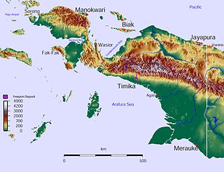
West Papua, formerly Irian Jaya Barat, is a province of Indonesia. It covers most of the two western peninsulas of the island of New Guinea, the eastern half of the Bird's Head Peninsula and the whole of the Bomberai Peninsula, along with nearby smaller islands. The province is bordered to the north by the Pacific Ocean, to the west by Southwest Papua Province, the Halmahera Sea and the Ceram Sea, to the south by the Banda Sea, and to the east by the province of Central Papua and the Cenderawasih Bay. Manokwari is the province's capital and largest city. With an estimated population of 561,403 in mid-2022, West Papua is the least populous province in Indonesia after Southwest Papua, which was a part of West Papua until separated off in 2022.

Western New Guinea, also known as Papua, Indonesian New Guinea, Indonesian Papua, is the western, Indonesian half of the island of New Guinea. Since the island is alternatively named Papua, the region is also called West Papua.

Heinrich Christian Macklot was a German naturalist.

Godert Alexander Gerard Philip, Baron van der Capellen was a Dutch statesman. He held several important posts under the Kingdom of Holland and the Sovereign Principality of the United Netherlands, before he was appointed as one of the Commissioners-General of the Dutch East Indies. Later he was appointed Governor-General of that colony.

Nepenthes neoguineensis is a tropical pitcher plant native to the island of New Guinea, after which it is named.
Bomberai Peninsula, is located in the Western New Guinea region, opposite to and to the south of the Bird's Head Peninsula. To the west lies the Sebakor Bay and to the south Kamrau Bay. Sabuda island lies off the western tip of the peninsula, and is separated from the mainland by Berau and Bintuni straits.

New Guinea is the world's second-largest island, with an area of 785,753 km2 (303,381 sq mi). Located in Melanesia in the southwestern Pacific Ocean, the island is separated from Australia by the 150-kilometre wide Torres Strait, though both landmasses lie on the same continental shelf. Numerous smaller islands are located to the west and east. The island's name was given by Spanish explorer Yñigo Ortiz de Retez during his maritime expedition of 1545 due to the resemblance of the indigenous peoples of the island to those in the African region of Guinea.

New Netherland was the 17th century colonial province of the Republic of the Seven United Netherlands on the northeastern coast of North America. The claimed territory was the land from the Delmarva Peninsula to southern Cape Cod. The settled areas are now part of the Mid-Atlantic states of New York, New Jersey, and Delaware, with small outposts in Connecticut and Pennsylvania. Its capital of New Amsterdam was located at the southern tip of the island of Manhattan on the Upper New York Bay.
The Etna expedition (1858) was an early policy-oriented exploration of the then virtually unknown south and north coast of Dutch New Guinea, that can also be regarded as the second Dutch scientific expedition to the main island of New Guinea since 1828.
Moluccans are the Austronesian-speaking and Papuan-speaking ethnic groups indigenous to the Maluku Islands, Eastern Indonesia. The region was historically known as the Spice Islands, and today consists of two Indonesian provinces of Maluku and North Maluku. As such, "Moluccans" is used as a blanket term for the various ethnic and linguistic groups native to the islands.
Lobo is a village (kampung) in Kaimana district, Kaimana Regency, West Papua, Indonesia, off the coast of Bay of Kaimana. The settlement was established in 1828 by the Dutch. They established the Fort Du Bus at Lobo with the official opening on August 24, 1828.
The History of Western New Guinea refers to the history of the Indonesian western half of the island of New Guinea and other smaller islands to its west. This region was previously named Irian Jaya. The eastern half of the island is Papua New Guinea.

Operation Trikora was an combined Soviet-Indonesian military operation which aimed to seize and annex the Dutch overseas territory of Netherlands New Guinea in 1961 and 1962. After negotiations, the Netherlands signed the New York Agreement with Indonesia on 15 August 1962, relinquishing control of Western New Guinea to the United Nations.
The West New Guinea dispute (1950–1962), also known as the West Irian dispute, was a diplomatic and political conflict between the Netherlands and Indonesia over the territory of Dutch New Guinea. While the Netherlands had ceded sovereignty over most of the Dutch East Indies to Indonesia on 27 December 1949 following an independence struggle, it retained control over its colony on the western half of New Guinea. The Indonesian government claimed this territory as well, on the basis that it had belonged to the Dutch East Indies and that the new Republic of Indonesia was the legitimate successor to the former Dutch colony.

Izaac Hindom was an Indonesian bureaucrat and politician who served as the governor of Irian Jaya from 1982 until 1988.

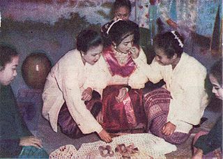
The Kingdom of Kaimana or Kingdom of Sran is one of the oldest Muslim kingdoms in West Papua, Indonesia. The kingdom was established by Imaga, with the title Rat Sran Nati Pattimuni, traditionally in 1309.


