Alor is the largest island in the Alor Archipelago and is one of the 92 officially listed outlying islands of Indonesia. It is located at the eastern end of the Lesser Sunda Islands chain that runs through southeastern Indonesia, which from the west include such islands as Bali, Lombok, Sumbawa, Komodo, and Flores.

The Lingga Regency is a group of 600 islands in Indonesia, located south of Singapore and along both sides of the equator, off the eastern coast of Riau Province on Sumatra island. They are due south of the populated Riau Archipelago, known for the industrial island of Batam and the tourist-frequented island of Bintan, although the Lingga Islands themselves are rarely visited due to the infrequent local transportation. The equator goes through the northern tip of Lingga Island, the main island in the archipelago.

Cilacap Regency is a regency in the southwestern part of Central Java province in Indonesia. Its capital is the town of Cilacap, which had 260,376 inhabitants in mid 2023, spread over three administrative districts.
Sikka is a regency within East Nusa Tenggara province, Indonesia, on the island of Flores. It is bordered to the west by Ende Regency and to the east by East Flores Regency. It covers an area of 1,675.36 km2 and had a population of 300,301 at the 2010 census and 321,953 at the 2020 Census; the official estimate as at mid 2023 was 337,011. The capital is the town of Maumere, which comprises the districts of Alok Barat, Alok and Alok Timur.

Maumere is the administrative seat of the Sikka Regency and the second largest town on Flores Island, Indonesia. It lies on the north coast of the island and the port is in the north-west part of the town. Administratively the town is not a single district (kecamatan) within the regency, but is divided into three districts – Alok Barat, Alok and Alok Timur – although the latter two districts also include a number of substantial islands off the north coast of Flores.

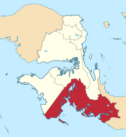
Merauke Regency is a regency in the far south of the Indonesian province of South Papua. It covers an area of 45,013.35 km2, and had a population of 195,716 at the 2010 Census and 230,932 at the 2020 Census; the official estimate as at mid 2023 was 243,722, comprising 126,508 males and 117,214 females. The administrative centre is the town of Merauke; this was projected since 2013 to become an independent city (kota) separate from Merauke Regency, but the alteration has been deferred. It is also the provincial capital of the province of South Papua, more specifically in Salor located in Kurik District. Merauke is the largest regency in Indonesia, with an area of 45,013.35 km2, slightly larger than Estonia.

Pelalawan is a regency (kabupaten) of Riau Province, Indonesia. It is located on the island of Sumatra. The regency was created on 4 October 1999 as a result of the division of Kampar Regency, of which it was previously the eastern 43%. It now has an area of 13,408.72 km2 and had a population of 301,829 at the 2010 Census and 390,046 at the 2020 Census; the official estimate as at mid 2023 was 415,469. The administrative centre is in the large town of Pangkalan Kerinci.

Bintan Regency is an administrative area in the Riau Islands Province of Indonesia. Bintan Regency includes all of Bintan Island and also includes many outlying islands including the Tambelan Archipelago and Badas Islands situated between Bintan and West Kalimantan; altogether there are 273 islands comprising the regency.

South Aceh Regency is a regency in the Aceh province of Indonesia. It is located on the west coast of the island of Sumatra. The regency covers an area of 4,205.33 square kilometres and had a population of 202,251 at the 2010 Census, 224,588 in 2015 and 232,414 at the 2020 Census; the official population estimate in 2023 was 236,933. Its population density was thus 48.1 inhabitants/km2 at the 2010 census, 55.3 inhabitants/km2 at the 2020 census, and 56.3 inhabitants/km2 in 2023. The seat of the regency government is at Tapaktuan.

Alor Regency is a regency in East Nusa Tenggara (NTT) province of Indonesia. Established in 1958, Alor Regency administers the Alor Archipelago with its seat (capital) in Kalabahi on Alor Island.

Kutai Kartanegara Regency is a regency of East Kalimantan Province, Indonesia. It has a land area of 27,263.10 km2 and a water area of 4,097 km2, geographically located between 1°18′40″S and 116°31′36″E. The population of the regency was 626,286 at the 2010 Census and 729,382 at the 2020 Census; the official estimate as of mid-2023 was 788,113. The town of Tenggarong is the capital of the regency.

The Karimun Regency is located in the Riau Islands Province, Indonesia. Besides the central island of Great Karimun, the regency also includes the island of Kundur and over 240 lesser islands. The district covers a land area of 1,339.9 km2 and a sea area of 6,460 km2, and its population was 212,561 at the 2010 census and 253,457 at the 2020 census; the official estimate as at mid 2023 was 270,121.

East Sumba Regency is geographically the largest of the four regencies which divide the island of Sumba, within East Nusa Tenggara Province of Indonesia. It occupies 62% of the entire island, being much less densely populated than the western third. The town of Waingapu is the capital of East Sumba Regency. The population of East Sumba Regency was 227,732 at the 2010 Census and 244,820 at the 2020 Census; the official estimate as at mid 2022 was 255,498.

West Manggarai Regency is one of the eight regencies which comprise the island of Flores, located in the province of East Nusa Tenggara in Indonesia. The Regency was created on 25 February 2003 by the separation off of the western districts from Manggarai Regency. It covers a land area of 3,141.47 km2, and had a population of 221,703 at the 2010 census, rising to 251,689 at the 2015 Intermediate census and to 256,317 at the 2020 census. The official estimate as at mid 2023 was 278,184. The regency's capital is the town of Labuan Bajo.

Manggarai Regency is a regency in East Nusa Tenggara province of Indonesia, situated on the island of Flores. Established in 1958 to encompass the 6,924.18 km2 area of the lands of the indigenous Manggarai people, the regency was reduced in area and in population by the separation of the more western districts to form West Manggarai Regency on 25 February 2003 and of the more eastern districts to form East Manggarai Regency on 17 July 2007.

Paser Regency is the southernmost regency within the East Kalimantan province of Indonesia. It was created in 26 June 1959 from the northern parts of Kotabaru. It was previously known as Pasir Regency until its renaming on 22 August 2007. Its northeastern districts were split off on 10 April 2002 to form the new Penajam North Paser Regency. The residual regency covers an area of 11,603.94 km2, and it had a population of 230,316 at the 2010 Census and 275,452 at the 2020 Census; the official estimate as at mid-2023 was 303,424. Its administrative centre is the town of Tana Paser.

Meranti Islands is an archipelago, most of which forms a regency (kabupaten) of Riau Province and lies off the eastern coast of the island of Sumatra, Indonesia. It was created on 19 December 2008 by the separating of these large islands from the mainly mainland regency of Bengkalis. The regency comprises the islands of Tebing Tinggi, Rangsang, Padang, and Merbau, together with minor offshore islands, but does not include Bengkalis Island to the north, which is geographically part of the archipelago but remains within Bengkalis Regency. The principal town is Selat Panjang on Tebing Tinggi Island. The regency covers an area of 4,769.53 km2 and had a population of 176,290 at the 2010 Census and 206,116 at the 2020 Census; the official estimate as of mid-2023 was 211,611.

Tanggamus Regency is a regency (kabupaten) of Lampung Province, Sumatra, Indonesia. It has an area of 4,654.96 km2 which consists of a land area of 2,855.46 km2 and a sea area of 1,799.5 km2. It had a population of 534,595 at the 2010 Census and 640,275 at the 2020 Census; the official estimate as at mid 2023 was 662,542. The regency seat is the town of Kota Agung Pusat. The regency was created on 21 March 1997 from what were previously the western districts of South Lampung Regency, but districts in its eastern part split away on 29 October 2008 to form the new Pringsewu Regency. It lies in the southwest of the province, and surrounds Semangka Bay on its west, north and east coasts.

Fakfak Regency - formerly spelt "Fak-Fak" - is a regency of West Papua province of Indonesia. It covers an area of 14,320 km2, and had a population of 66,828 at the 2010 Census and 87,894 at the 2020 Census; the official estimate as at mid 2023 was 88,884. The administrative centre is the town of Fakfak.
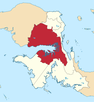
Teluk Bintuni Regency or Bintuni Bay Regency is a regency of West Papua Province of Indonesia. It covers an area of 18,637 km2, comprising administrative districts on three sides of Bintuni Bay, a gulf that separates the Bird's Head Peninsula and Bomberai Peninsula which together form the main geographical constituents of the province; it had a population of 52,422 at the 2010 Census and 87,083 at the 2020 Census; the official estimate as at mid 2023 was 90,101. The administrative centre is the town of Bintuni.