Adi Island

Last updated

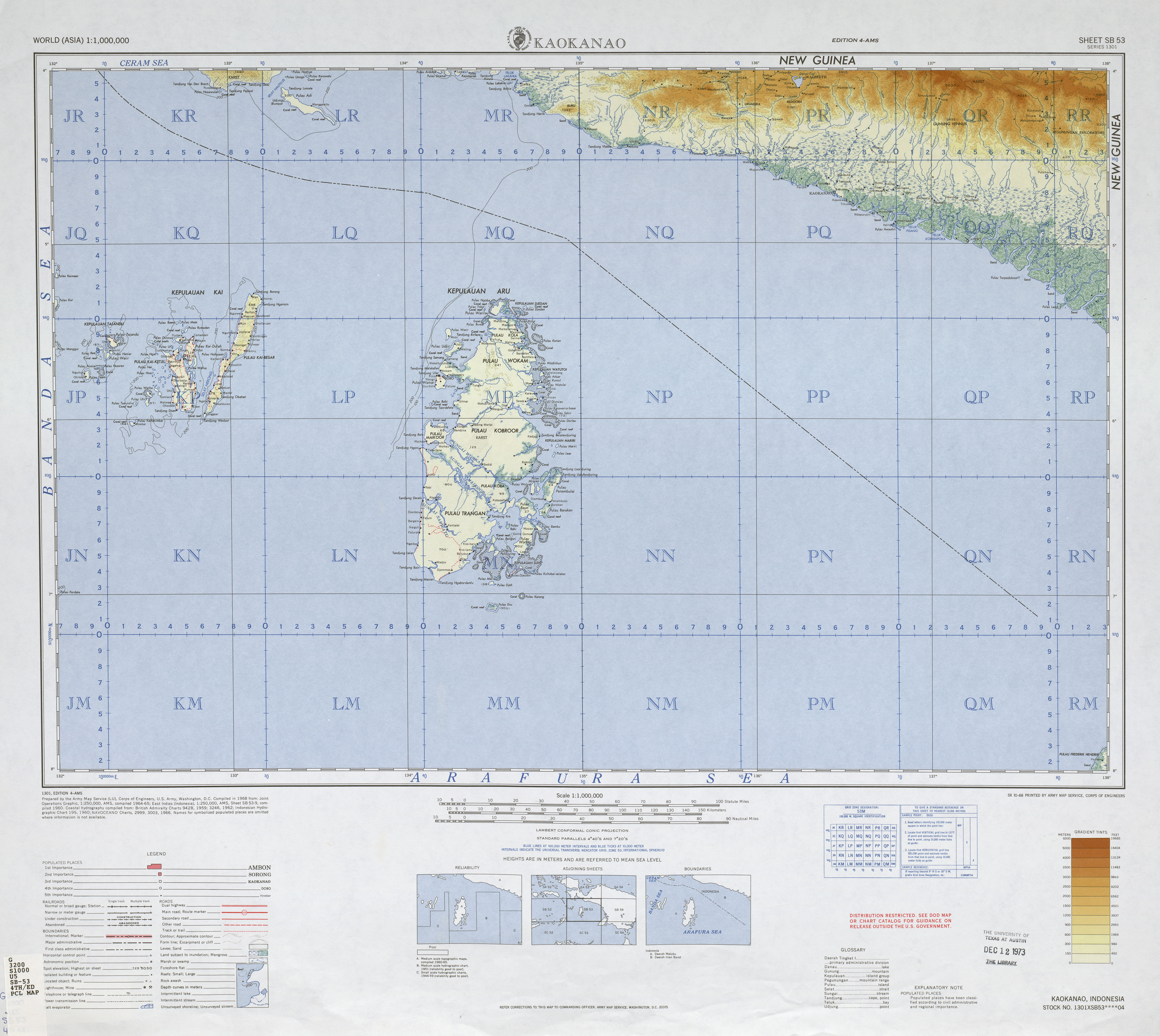
Adi (or Adi Island, Indonesian: Pulau Adi) is an Indonesian island.

Adi is located approximately 450 kilometres (280 mi) south of the equator in the Seram Sea off the western coast of New Guinea. It is severed from the Bomberai Peninsula by Nautilus Strait, the narrowest width of which is only ten kilometres (6.2 mi). Adi marks the southern border of the Kamrau Bay; beyond lies the open Seram Sea. [1]

Related Research Articles

Geography of Indonesia Aspect of Indonesia

Indonesia is an archipelagic country located in Southeast Asia, lying between the Indian Ocean and the Pacific Ocean. It is located in a strategic location astride or along major sea lanes connecting East Asia, South Asia and Oceania. Indonesia is the largest archipelago in the world. Indonesia's various regional cultures have been shaped—although not specifically determined—by centuries of complex interactions with its physical environment.

Maluku Islands Archipelago in eastern Indonesia, also called the Spice Islands

The Maluku Islands or the Moluccas (Molukken) are an archipelago in the east of Indonesia. Tectonically they are located on the Halmahera Plate within the Molucca Sea Collision Zone. Geographically they are located east of Sulawesi, west of New Guinea, and north and east of Timor. Lying within Wallacea, the Maluku islands have been considered part of both Asia and Oceania.

Ambon Island Island of Indonesia

Ambon Island is part of the Maluku Islands of Indonesia. The island has an area of 743.37 km2 (287.02 sq mi) and is mountainous, well watered, and fertile. Ambon Island consists of two territories - the city of Ambon to the south and various districts (kecamatan) of the Central Maluku Regency to the north. The main city and seaport is Ambon, which is also the capital of Maluku province, while those districts of Maluku Tengah Regency situated on Ambon Island had a 2020 Census population of 128,069. Ambon has an airport and is home to the Pattimura University and Open University, state universities, and a few private universities, which include Darussalam University and Universitas Kristen Indonesia Maluku (UKIM).

Seram Island Main island of Maluku Province, Indonesia

Seram is the largest and main island of Maluku province of Indonesia, despite Ambon Island's historical importance. It is located just north of the smaller Ambon Island and a few other adjacent islands, such as Saparua, Haruku, Nusa Laut and the Banda Islands.

Wallacea Biogeographical region

Wallacea is a biogeographical designation for a group of mainly Indonesian islands separated by deep-water straits from the Asian and Australian continental shelves. Wallacea includes Sulawesi, the largest island in the group, as well as Lombok, Sumbawa, Flores, Sumba, Timor, Halmahera, Buru, Seram, and many smaller islands. The islands of Wallacea lie between the Sunda Shelf to the west, and the Sahul Shelf including Australia and New Guinea to the south and east. The total land area of Wallacea is 347,000 km2 (134,000 sq mi).

Banda Sea A sea between Sulawesi and Maluku

The Banda Sea is a sea in the Maluku Islands of Indonesia, connected to the Pacific Ocean but surrounded by hundreds of islands, as well as the Halmahera and Ceram Seas. It is about 1000 km (600 mi) east to west, and about 500 km (300 mi) north to south.

Buru Island in Maluku, Indonesia

Buru is the third largest island within Maluku Islands of Indonesia. It lies between the Banda Sea to the south and Seram Sea to the north, west of Ambon and Seram islands. The island belongs to Maluku province and includes the Buru and South Buru regencies. Their administrative centers, Namlea and Namrole, respectively, have ports and the largest towns of the island. There is a military airport at Namlea which supports civilian cargo transportation.

Maluku (province) Province of Indonesia

Maluku is a province of Indonesia. It comprises the central and southern regions of the Maluku Islands. The main city and capital of Maluku province is Ambon on the small Ambon Island. The land area is 62,946 km2, and the total population of this province at the 2010 census was 1,533,506 people, rising to 1,848,923 at the 2020 Census. Maluku is located in Eastern Indonesia. It is directly adjacent to North Maluku and West Papua in the north, Central Sulawesi, and Southeast Sulawesi in the west, Banda Sea, East Timor and East Nusa Tenggara in the south and Arafura Sea and Papua in the east.

Arafura Sea Marginal sea between Australia and Indonesian New Guinea

The Arafura Sea lies west of the Pacific Ocean, overlying the continental shelf between Australia and Western New Guinea, which is the Indonesian part of the Island of New Guinea.

Obi Islands Group of islands in North Maluku, Indonesia

The Obi Islands are a group of 42 islands in the Indonesian province of North Maluku. They lie north of Buru and Ceram. They cover a land area of 3,048.08 km2, and had a population of 41,455 at the 2010 Census, which had risen to 50,760 at the 2020 Census.

Flores Sea Indonesian sea between Celebes and the Sunda Islands of Flores and Sumbawa

The Flores Sea covers 240,000 square kilometres (93,000 sq mi) of water in Indonesia. The sea is bounded on the north by the island of Celebes and on the south by Sunda Islands of Flores and Sumbawa.

Seram Sea One of several small seas between the scattered islands of Indonesia

The Seram Sea or Ceram Sea is one of several small seas between the scattered islands of Indonesia. It is a section of the Pacific Ocean with an area of approximately twelve thousand square kilometres (4,600 sq mi) located between Buru and Seram, which are two of the islands once called the South Moluccas. These islands are the native habitat of plants long coveted for their use as spices, such as nutmeg, cloves, and black peppercorns, and the seas surrounding them were busy shipping routes. The Seram Sea is also the habitat of several species of tropical goby and many other fish. Like many other small Indonesian seas, the Seram Sea is rocky and very tectonically active.

Central Malayo-Polynesian languages Proposed branch of the Austronesian language family

The Central Malayo-Polynesian languages (CMP) are a proposed branch in the Malayo-Polynesian subgroup of the Austronesian language family. The languages are spoken in the Lesser Sunda and Maluku Islands of the Banda Sea, in an area corresponding closely to the Indonesian provinces of East Nusa Tenggara and Maluku and the nation of East Timor, but with the Bima language extending to the eastern half of Sumbawa Island in the province of West Nusa Tenggara and the Sula languages of the Sula archipelago in the southwest corner of the province of North Maluku. The principal islands in this region are Sumbawa, Sumba, Flores, Timor, Buru, and Seram. The numerically most important languages are Bima, Manggarai of western Flores, Uab Meto of West Timor, and Tetum, the national language of East Timor.

Banda Neira

Banda Neira is an island in the Banda Islands, Indonesia. It is administered as part of the administrative Banda Islands District within the Central Maluku Regency in the province of Maluku. To the south is the main town of the same name, which is the largest town in the archipelago with around 7,000 inhabitants.

Banda Sea Plate Minor tectonic plate underlying the Banda Sea in southeast Asia

The Banda Sea Plate is a minor tectonic plate underlying the Banda Sea in southeast Asia. This plate also carries a portion of Sulawesi Island, the entire Seram Island, and the Banda Islands. Clockwise from the east it is bounded by the Bird's Head Plate of western New Guinea, Australian Plate, Timor Plate, Sunda Plate, and the Molucca Sea Collision Zone.

Opin Village in Warmian-Masurian Voivodeship, Poland

Opin is a village in the administrative district of Gmina Orneta, within Lidzbark County, Warmian-Masurian Voivodeship, in northern Poland.

Banda Arc Set of island arcs in eastern Indonesia

The Banda Arc is a set of island arcs in eastern Indonesia. It is the result of the collision of a continent and an intra-oceanic island arc. The presently active arc is located on what appears to be oceanic crust whereas the associated subduction trench is underlain by continental crust. The convergence of the Indo-Australian plates and Eurasia resulted in the formation of the Sunda and Banda island arcs. The transitional zone between the arcs is located south of Flores Island and is characterized by the change in the tectonic regime along the boundary.

1629 Banda Sea earthquake natural disaster in Indonesia

The 1629 Banda Sea earthquake struck the Banda Sea, Indonesia on August 1. Its epicentre is believed to have been in the Seram Trough. A megathrust earthquake caused a 15 m (49 ft) tsunami, which was recorded to have affected the Banda Islands about 30 minutes after the quake. The effects of the tsunami were reported as far as 230 kilometres (140 mi) away in Ambon. Many trees in the Banda Islands were reported to have been uprooted.

Masiwang River

Masiwang River is a river of eastern Seram Island, Maluku province, Indonesia, about 2700 km northeast of the capital Jakarta.

Eti River

Eti River is a river of Seram Island, Maluku province, Indonesia, about 2400 km northeast of the capital Jakarta. It flows into the sea on the southwest side of the island, a few kilometres south of the town of Piru, West Seram Regency.

References

  1. "National Geographic Adi Island".

Coordinates: 4°12′25″S133°27′22″E / 4.207°S 133.456°E / -4.207; 133.456