The New Caledonia rain forests are a terrestrial ecoregion, located in New Caledonia in the South Pacific. It is a tropical moist broadleaf forest ecoregion, part of the Australasian realm.

The Cape Verde Islands dry forests is a tropical and subtropical dry broadleaf forests ecoregion in the Cape Verde Islands, which constitute the country of Cabo Verde. The islands lie off the western coast of Africa.
The Tropical Rainforest Heritage of Sumatra site was inscribed as a UNESCO World Heritage Site in 2004. It comprises three Indonesian national parks on the island of Sumatra: Gunung Leuser National Park, Kerinci Seblat National Park and the Bukit Barisan Selatan National Park. The site is listed under Criteria vii - outstanding scenic beauty; ix- an outstanding example representing significant on-going ecological and biological processes; and x- contains the most important and significant natural habitats for in-situ conservation. The Tropical Rainforest Heritage of Sumatra has been placed on the Danger List since 2011 to help overcome threats posed by poaching, illegal logging, agricultural encroachment, and plans to build roads through the site.

The Himalayan subtropical broadleaf forests is an ecoregion that extends from the middle hills of central Nepal through Darjeeling into Bhutan and also into the Indian States of Uttar Pradesh and Bihar. It represents the east–west-directed band of subtropical broadleaf forest at an altitude of between 500 and 1,000 m along the Outer Himalayan Range, and includes several forest types traversing an east to west moisture gradient.
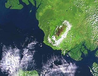
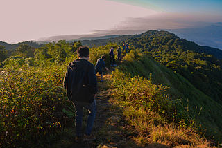
The Mount Cameroon and Bioko montane forests is a tropical moist broadleaf forest ecoregion in central Africa. It occupies the upper slopes of coastal Mount Cameroon in Cameroon, and the mountains of nearby Bioko island in Equatorial Guinea.
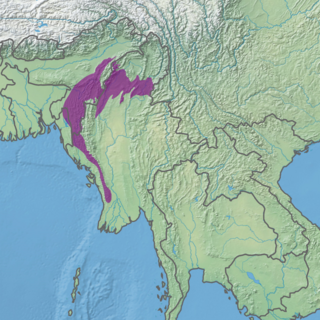
The Mizoram–Manipur–Kachin rain forests is a subtropical moist broadleaf forest ecoregion which occupies the lower hillsides of the mountainous border region joining Bangladesh, China's Yunnan Province, India, and Myanmar. The ecoregion covers an area of 135,600 square kilometres (52,400 sq mi). Located where the biotas of the Indian Subcontinent and the Indochinese Peninsula meet, and in the transition between subtropical and tropical regions of Asia, the Mizoram–Manipur–Kachin rain forests are home to great biodiversity. The WWF rates the ecoregion as "Globally Outstanding" in biological distinctiveness.

The New Caledonia dry forests is a tropical dry broadleaf forest ecoregion in New Caledonia, an overseas territory of France located in the South Pacific Ocean. The dry forests cover the western side of Grand Terre, New Caledonia's largest island.

The Nelson Coast temperate forests is an ecoregion in New Zealand.

The Borneo montane rain forests is an ecoregion on the island of Borneo in Southeast Asia. It includes montane tropical and subtropical moist broadleaf forests, also known as a cloud forests. The ecoregion is partly in East Malaysia and Indonesia (Kalimantan).

The Luzon tropical pine forests are a tropical coniferous forest ecoregion of the Philippines in the western Pacific Ocean. These pine forests are home to a large number of the island's endemic plants and animals.
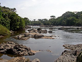
The Northeastern Congolian lowland forests is a tropical moist broadleaf forest ecoregion that spans the Democratic Republic of the Congo and the Central African Republic.

The Peninsular Malaysian rain forests is an ecoregion on the Malay Peninsula and adjacent islands. It is in the tropical and subtropical moist broadleaf forests biome.

The Peninsular Malaysian montane rain forests is an ecoregion on the Malay Peninsula. It occupies the mountainous spine of the peninsula in Malaysia and southernmost Thailand. It is in the tropical and subtropical moist broadleaf forests biome.
The Kayah–Karen montane rain forests is a tropical moist broadleaf forest ecoregion on Mainland Southeast Asia. The montane rain forests cover several connected mountain ranges, including the Daen Lao Range, the Dawna Range, the Karen Hills, the Khun Tan Range, and the Thanon Thong Chai Range.

The Myanmar coastal rain forests is a tropical moist broadleaf forest ecoregion on Mainland Southeast Asia. The ecoregion occupies Myanmar's coastal lowlands along the Andaman Sea and the Bay of Bengal.

The Northern New Guinea montane rain forests is a tropical moist forest ecoregion in northern New Guinea. The ecoregion covers several separate mountain ranges lying north of New Guinea's Central Range and south of the Pacific Ocean.
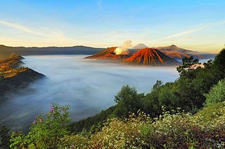
The Eastern Java–Bali montane rain forests ecoregion covers the higher altitude mountain rainforests on the eastern side of the island of Java, and most of the center of the island of Bali in Indonesia. The region has a number of active volcanoes, but is under pressure from growing human populations pushing into higher elevations and more marginal land. With elevations rising from sea level to 3,426 metres (11,240 ft), and precipitation varying between rainforest and drier forest levels, the area has many different forest types – evergreen, deciduous and semi-alpine.

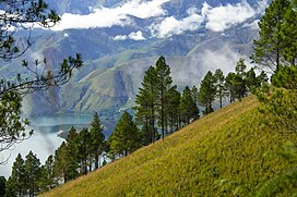
The Sumatran montane rain forests ecoregion covers the mountainous elevations of the Barisan Mountains Range that runs the length of the southwestern side of the island of Sumatra in Indonesia. The ecoregion is almost completely surrounded by the lower elevation Sumatran lowland rain forests. The area is one of very high biodiversity - because of the relative isolation, and variety of forest types, there are 7 endemic species of mammals and eight endemic species of birds.
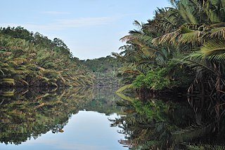
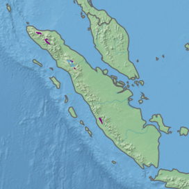
The Sumatran peat swamp forests ecoregion covers the low-lying peat swamp forests along the northeast coast of the island of Sumatra in Indonesia. As is typical for peat swamp forests, this ecoregion lies between a thin strip of saltwater-affected mangroves on the coast, and freshwater swamps and lowland rainforest forest on better drained soils further inland. Because the peat soil has relatively low nutrient levels, this ecoregion has been less used for agriculture, but burning and clearance has degraded half of the forest.