The Ucayali moist forests (NT0174) is an ecoregion in the western Amazon rainforest of Peru.

The Luang Prabang montane rain forests ecoregion covers elevations over 800 meters in the Luang Prabang mountains that straddle the border between northern Thailand and north-central Laos, and the highlands that stretch eastward across north-central Laos. While much of the forest cover has been degraded, there are still large areas of relatively untouched forest.

The Northern Annamites rain forests ecoregion covers the rugged and relatively unexplored northern Annamite Mountains of central Laos and Vietnam. There are high numbers of endemic plant species, and the relative remoteness and isolation of the area supports many rare and endangered animals. Rainfall is somewhat less than the lowland rainforest of the lower elevations in Vietnam, and the temperatures slightly cooler due to the higher elevation.
The Southern Annamites montane rain forests ecoregion covers a region of high biodiversity in the central and southern mountains of the Annamite Range in Vietnam. Terrain ranges from wet lowland forest to evergreen hardwood and conifer montane rain forest. There is a short dry season centered on January–February, but fog and dew are common throughout the year and support a lush forest character.

The Northern Khorat Plateau moist deciduous forests ecoregion covers a small area on the border between northeastern Thailand and Laos, in the transition zone between the drier Khorat Plateau to the south and the wetter Annamite Range and Luang Prabang Range mountains to the north. Much of the ecoregion has been converted to agriculture along the floodplain of the middle course of the Mekong River.
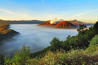
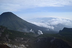
The Eastern Java–Bali montane rain forests ecoregion covers the higher altitude mountain rainforests on the eastern side of the island of Java, and most of the center of the island of Bali in Indonesia. The region has a number of active volcanoes, but is under pressure from growing human populations pushing into higher elevations and more marginal land. With elevations rising from sea level to 3,426 metres (11,240 ft), and precipitation varying between rainforest and drier forest levels, the area has many different forest types – evergreen, deciduous and semi-alpine.
The Eastern Java-Bali rain forests ecoregion covers the lowland areas of the eastern half of the island of Java, and the island of Bali, in Indonesia. This ecoregion is distinct from the Eastern Java-Bali montane rain forests, which exists at higher elevations where mountain forest habitat dominates. Very little of the natural lowland rainforest remains in its pre-human settlement state.

The Sumatran freshwater swamp forests ecoregion covers disconnected patches of freshwater swamp forest on the alluvial plains of the island of Sumatra in Indonesia. The different locations vary greatly in their vegetation and wildlife habitat depending on the local soil types. The land has been greatly disturbed by human conversion to agriculture and illegal logging in recent years. Several of the sectors support significant populations of Asian elephants (Elephas maximus)'.

The Sumatran lowland rain forests ecoregion covers the lowland forests running the length of the island of Sumatra in Indonesia. The region is one of exceptionally high biodiversity, similar to Borneo and New Guinea islands. Many endangered mammals species are present, and over 450 species of birds have been found in the region. In recent years, illegal logging and human encroachment have put great strain on this ecoregion.

The Sumatran montane rain forests ecoregion covers the mountainous elevations of the Barisan Mountains Range that runs the length of the southwestern side of the island of Sumatra in Indonesia. The ecoregion is almost completely surrounded by the lower elevation Sumatran lowland rain forests. The area is one of very high biodiversity - because of the relative isolation, and variety of forest types, there are 7 endemic species of mammals and eight endemic species of birds.

The Mindanao montane rain forests ecoregion covers the montane forests - the zone between the lowland forest and the treeline - in the mountains on the island of Mindanao in the Philippines. Because the ecoregion covers only elevations above 1,000 metres (3,300 ft), it exists in seven discontinuous patches surrounded by lowland rainforest. Biodiversity is high, both because of the isolation of separate mountain ranges that have led to species variation within the island, and because of the altitude zonation. Because most of the surrounding lowland forest has been cleared for human use, the montane regions have become an important refuge for rare and endemic species.

The Greater Negros–Panay rain forests ecoregion covers the central Visayan Islands in the Philippines, including the islands of Panay, Negros, Cebu, Masbate, Sibuyan, Ticao, Guimaras, Romblon, Tablas, Siquijor, and Bohol, but excludes Leyte and Samar. During the last ice age, these were all on the same island. The lack of a land bridge to Asia during the ice age kept most Asian megafauna, including elephants and tigers, from reaching the Philippines and the Visayan Islands, which hosts many unique and endemic species with some exclusive only to an island.

The Mindanao–Eastern Visayas rain forests ecoregion covers the lowland rain forests of the island of Mindanao and of the easternmost of the Visayas Islands in the Philippines. Although 63% of this ecoregion is covered with closed broadleaf evergreen forest or open forest, much of this has been disturbed in the past by human activity, and many of the rare species of the area have been relegated to the isolated areas or higher elevations.

The Mindoro rain forests ecoregion covers the island of Mindoro, which lies between the island of Luzon and the Palawan Archipelago in the Philippines. The island has been subject to heavy commercial logging, with the only original forests remaining on the high ridge of the central mountain range. Logging has been reduced long enough on the east side of the mountains to support a regrown forest and a number of endemic species.

The Palawan rain forests ecoregion covers the Palawan Island Archipelago, centered on Palawan Island, the sixth largest island in the Philippines. The islands act as an ecological bridge between Borneo and the main islands of the Philippines, even though there were channels between the islands through the last ice age when sea levels were low. Biodiversity is high in the islands, with many endemic species, and with many genera shared with Borneo to the south. Pressure from logging is a concern for the forests of this region.

The Sulu Archipelago rain forests ecoregion covers the Sulu Archipelago, excepting Basilan Island at the northern end, in the southwest of the Philippines. The islands are separated enough from Borneo to the south and Mindanao to the north that they have developed their own distinctive floral and faunal communities. Most of the original rainforest has been removed or disturbed for agriculture, and political instability in the islands has hampered conservation efforts.

The Western Java rain forests ecoregion covers the lowland rain forests below 1,000 meters in elevation in the western half of the island of Java in Indonesia. There are a variety of forest types - evergreen, semi-evergreen, moist deciduous, and even some patches of freshwater swamp. The forests have degraded by conversion of the low areas to agriculture, and by logging. National parks protect some of the last remaining untouched rain forest. A number of endangered mammals are found in the ecoregion, including the Javan rhinoceros, the silvery gibbon, and the Javan surili.
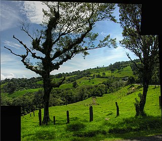
The Costa Rican seasonal moist forests ecoregion covers the Pacific Slope of the volcanic mountain range of northwestern Costa Rica and the extreme south of Nicaragua. The area has a distinct dry season during which the characteristic deciduous trees drop their leaves. The forests themselves have been highly degraded in the past by human conversion to agriculture and settlement. The Costa Rican capital city of San Jose is in the middle of this ecoregion.

The Isthmian–Pacific moist forests ecoregion covers the lowland tropical evergreen forests on the Pacific side of the central mountains of southern Costa Rica and western Panama. As the meeting zone between North and South American floral communities, the area is one of very high biodiversity. Much of the rainforest has, however, been cleared for subsistence agriculture and cattle grazing.

The Leeward Islands moist forests ecoregion covers the forested areas of the Leeward Islands on the northeastern edge of the Caribbean Sea, stretching from the Virgin Islands in the west to Guadeloupe to the southeast. The forested areas are typically in the core interior of the islands, and at the higher elevations of the volcanic islands. Non-forested lower elevations in the region receive less rainfall and are typically semi-arid. A notable feature of the ecoregion is its position in the main hurricane track. The frequent damage to trees produces in many places an uneven forest canopy, and an opening of the canopy that allows more pre-climax trees to grow.