Mount Sindoro | |
---|---|
Mount Sundoro | |
![]() | |
Highest point | |
Elevation | 3,136 m (10,289 ft) [1] |
Prominence | 1,747 m (5,732 ft) |
Listing | Ultra Ribu |
Coordinates | 7°18′02.91″S109°59′46.34″E / 7.3008083°S 109.9962056°E |
Geography | |
Location | Java, Indonesia |
Parent range | Sunda Arc |
Geology | |
Age of rock | 659.000 years |
Mountain type | Stratovolcano |
Last eruption | October to November 1971 |
Climbing | |
Easiest route | Gubugklakah, Burno |
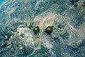
Mount Sindoro, Mount Sindara or Mount Sundoro is an active stratovolcano in Central Java, Indonesia. Parasitic craters and cones are found in the northwest-southern flanks; the largest is called Kembang. A small lava dome occupies the volcano's summit. Historical eruptions have been mostly mild to moderate. [1]
The Sindoro mountain complex serves as the headwaters for the Progo river basin on the eastern slope and the Serayu river basin on the western slope. The boundary between the headwaters of these two river basins extends southeastward from the Sindoro mountain complex to the summit of Mount Sumbing. The headwaters of the Progo River basin on the eastern side flow through Temanggung, while the headwaters of the Serayu River basin on the western side flow through Wonosobo. Both of their mainstem ultimately discharge into the Indian Ocean, on the southern coast of Java, separated by a distance of approximately 125 kilometres (78 mi). [2]
The Great Dividing Range, also known as the East Australian Cordillera or the Eastern Highlands, is a cordillera system in eastern Australia consisting of an expansive collection of mountain ranges, plateaus and rolling hills. It runs roughly parallel to the east coast of Australia and forms the fifth-longest land-based mountain chain in the world, and the longest entirely within a single country. It is mainland Australia's most substantial topographic feature and serves as the definitive watershed for the river systems in eastern Australia, hence the name.
The Ring of Fire is a tectonic belt of volcanoes and earthquakes.
The Indonesian island of Java is almost entirely of volcanic origin, and contains numerous volcanoes, 45 of which are considered active volcanoes. As is the case for many other Indonesian islands, volcanoes have played a vital role in the geological and human history of Java. Indeed, land is created on Java as a result of lava flows, ash deposits, and mud flows (lahars). Volcanoes are a major contributor to the immense fertility of Java, as natural erosion transports volcanic material as alluvium to the island's plains, forming thick layers of fertile sediment. The benefit is not just in the immediate vicinity of the volcano, with fine ash emitted from eruptions being dispersed over wide areas.
Mount Garibaldi is a dormant stratovolcano in the Garibaldi Ranges of the Pacific Ranges in southwestern British Columbia, Canada. It has a maximum elevation of 2,678 metres and rises above the surrounding landscape on the east side of the Cheakamus River in New Westminster Land District. In addition to the main peak, Mount Garibaldi has two named sub-peaks. Atwell Peak is a sharp, conical peak slightly higher than the more rounded peak of Dalton Dome. Both were volcanically active at different times throughout Mount Garibaldi's eruptive history. The northern and eastern flanks of Mount Garibaldi are obscured by the Garibaldi Névé, a large snowfield containing several radiating glaciers. Flowing from the steep western face of Mount Garibaldi is the Cheekye River, a tributary of the Cheakamus River. Opal Cone on the southeastern flank is a small volcanic cone from which a lengthy lava flow descends. The western face is a landslide feature that formed in a series of collapses between 12,800 and 11,500 years ago. These collapses resulted in the formation of a large debris flow deposit that fans out into the Squamish Valley.
The Raung (ꦫꦲꦸꦁ), or Mount Raung is one of the most active volcanoes on the island of Java in Indonesia. It is located in the province of East Java and has a 2-kilometer-wide (1.2 mi) and 500-meter-deep (1,600 ft) caldera surrounded by a grayish rim. The difference in color of the rim and the flanks of the volcanoes is caused by the rim’s lack of vegetation compared with the healthy and extensive vegetation on the flanks. Raung, standing almost 3,332 metres (10,932 ft) above sea level, is the tallest volcano of this cluster.
Mount Sumbing or Gunung Sumbing is an active stratovolcano in Central Java, Indonesia that is symmetrical like its neighbour, Mount Sindoro. The only report of historical eruptions is from 1730. It has created a small phreatic crater at the summit.
Mount Salak is an eroded volcano in West Java, Indonesia. It has several satellite cones on its southeast flank and the northern foot, along with two additional craters at the summit. Mount Salak has been evaluated for geothermal power development. According to a popular belief, the name "Salak" is derived from salak, a tropical fruit with scaly skin; however, according to Sundanese tradition, the name was derived from the Sanskrit word Salaka which means "silver". Mount Salak can be translated to "Silver Mountain" or "Mount Silver".
Wayang-Windu is a twin volcano that consists of Mount Wayang and Mount Windu. They are located just to the east of the town of Pangalengan in the Bandung Regency in West Java, Indonesia, about 40 km (25 mi) south of the city of Bandung. The area has been an active geothermal project. Mount Wayang has a 750 m (2,500 ft) wide crescentic crater which holds four groups of fumaroles. Mount Windu has a 350 m (1,100 ft) wide crater.
Mount Ciremai/Cereme is a dominating symmetrical stratovolcano in West Java, Indonesia. It is located to the southwest of the major town of Cirebon. Mt Ciremai is strikingly visible towards the south from the main west–east corridor (Jakarta-Surabaya) rail link along the north coast of Java. It is the highest point in West Java.
Mount Gede Pangrango National Park is a national park in West Java, Indonesia. The park is centred on two volcanoes—Mount Gede and Mount Pangrango—and is 150 km² in area.
Temanggung Regency is an inland regency in the Central Java Province of Indonesia. It covers a land area of 870.65 km2 and had a population of 708,546 at the 2010 Census and 790,174 at the 2020 Census; the official estimate as of mid-2023 was 808,446, comprising 406,100 males and 402,346 females. Its capital is the town of Temanggung.
Opak River is a river in central south area of Java island, Indonesia.
Borobudur Temple Compounds is the World Heritage designation of the area of three Buddhist temples in Central Java, Indonesia. It comprises Borobudur, Mendut, and Pawon. The temples were built during the Shailendra dynasty around the 8th and 9th centuries CE and fall on a straight line.
The Canadian Cascade Arc, also called the Canadian Cascades, is the Canadian segment of the North American Cascade Volcanic Arc. Located entirely within the Canadian province of British Columbia, it extends from the Cascade Mountains in the south to the Coast Mountains in the north. Specifically, the southern end of the Canadian Cascades begin at the Canada–United States border. However, the specific boundaries of the northern end are not precisely known and the geology in this part of the volcanic arc is poorly understood. It is widely accepted by geologists that the Canadian Cascade Arc extends through the Pacific Ranges of the Coast Mountains. However, others have expressed concern that the volcanic arc possibly extends further north into the Kitimat Ranges, another subdivision of the Coast Mountains, and even as far north as Haida Gwaii.
The Bodri River is a river in Kendal Regency, northern Central Java, Indonesia. The Bodri River flows from the south to north into the Java Sea.
The Serayu River is a river in Central Java, Indonesia, about 300 km southeast of the capital Jakarta.
The Progo River is a river in southern central Java, Indonesia. The river passes through two provinces; Central Java and Yogyakarta Special Region. The source of the river is on the slopes of Mount Sindoro, Central Java.
Lake Bandung was a prehistoric lake located in and around the city of Bandung, Parahyangan highlands, West Java, Indonesia. believed to exist between 126,000 and 20,000 BCE in the Pleistocene due to the violent eruption of Mount Sunda that blocked the Citarum River, causing the lowlands to begin to be inundated with water, eventually forming a lake.