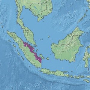
Sumatran peat swamp forests

Last updated
Sumatran peat swamp forests
Berbak National Park 2012.jpg
Berbak National Park 2012
Ecoregion IM0160.png
Ecoregion territory (in purple)
Ecology
Realm Indomalayan
Biome Tropical and subtropical moist broadleaf forests
Borders
Geography
Area87,706 km2 (33,863 sq mi)
Country Indonesia
Coordinates 0°30′N102°30′E / 0.5°N 102.5°E / 0.5; 102.5
Conservation
Conservation status critical/endangered
Protected7.67% [1]

The Sumatran peat swamp forests ecoregion (WWF ID: IM0160) covers the low-lying peat swamp forests along the northeast coast of the island of Sumatra in Indonesia. As is typical for peat swamp forests, this ecoregion lies between a thin strip of saltwater-affected mangroves on the coast, and freshwater swamps and lowland rain forest on better drained soils further inland. Because the peat soil has relatively low nutrient levels, this ecoregion has been less used for agriculture, but burning and clearance has degraded half of the forest. [2] [3] [1] [4]

Contents

Location and description

The ecoregion stretches for about 1,000 km down the south-eastern side of Sumatra, averaging 75 km wide, and separated from the sea by only a few kilometers of mangroves. It also covers the islands of Rupat, Bengkalis, Tebing Tinggi, Rangsang, and Mendol off the northeast coast of Sumatra. The peat swamps are ombrogenous (rain fed), and form where sediments have piled up behind the tangled brush of the mangroves. [4]

Climate

The climate of the ecoregion is Tropical rainforest climate (Köppen climate classification (Af)). This climate is characterized as hot, humid, and having at least 60 mm of precipitation every month. [5] [6]

Flora and fauna

The soil in the ecoregion is typically over 65%, with the peat at least 50 cm thick. Biodiversity and endemism of plants is relatively low, due to the specialized conditions of the soil. Habitat type depends on the local levels of nutrients and acidity, with the edges of the swamps generally more nutrient rich than the interior. [4] Characteristic trees of the region include Tristaniopsis obovata , Ploiarium elegans , Maasia glauca , Stemonurus secundiflorus , Cinnamomum cassia , Durio zibethinus , Garcinia mangostana , Artocarpus heterophyllus , Ficus benghalensis , Gnetum gnemon , Mangifera indica , Toona ciliata , Toona sinensis , Cocos nucifera , Tetrameles nudiflora , Ginkgo biloba , Shorea robusta , Prunus serrulata , Camphora officinarum , Tsuga dumosa , Ulmus lanceifolia , Tectona grandis , Terminalia elliptica , Terminalia bellirica , Quercus acutissima , and Nypa fruticans . Peat swamps tend to support fewer species of wildlife than richer habitat; there are no endemic mammals in this ecoregion, and relatively few species of birds. Land clearance for development, particularly in the south, is putting more pressure on the peat swamp forests. [4]

Protected areas

7.67% of the ecoregion is officially protected. These protected areas include: [1]

Related Research Articles

The Global 200 is the list of ecoregions identified by the World Wide Fund for Nature (WWF), the global conservation organization, as priorities for conservation. According to WWF, an ecoregion is defined as a "relatively large unit of land or water containing a characteristic set of natural communities that share a large majority of their species dynamics, and environmental conditions". For example, based on their levels of endemism, Madagascar gets multiple listings, ancient Lake Baikal gets one, and the North American Great Lakes get none.

<span class="mw-page-title-main">Sundaland heath forests</span> WWF ecoregion

The Sundaland heath forests, also known as Kerangas forest, is a type of tropical moist forest found on the island of Borneo, which is divided between Brunei, Indonesia, and Malaysia, as well as on the Indonesian islands of Belitung and Bangka, which lie to the west of Borneo.

<span class="mw-page-title-main">Northeastern Brazil restingas</span>

The Northeastern Brazil restingas are an ecoregion of northeastern Brazil. Restingas are coastal forests which form along coastal sand dunes in Brazil. The soils are typically sandy, acidic, and nutrient-poor, and are characterized by medium-sized trees and shrubs adapted to local conditions. Restingas have aspects of mangroves, caatingas, wetlands, and moist forests, often forming along wind-driven sand dunes. The Northeast Brazil restingas are the most northerly of the forest type in Brazil.

<span class="mw-page-title-main">Orinoco Delta swamp forests</span> Wetland region of Venezuela and Guyana

The Orinoco Delta swamp forests (NT0147) is an ecoregion of eastern Venezuela and northern Guyana covering the large and shifting Orinoco Delta. The vegetation is mostly permanently flooded rainforest. The ecoregion is relatively intact apart from a large area that was damaged by a failed flood control program in the 1960s. It is inaccessible, so logging is difficult, and the soil is unsuitable for farming. The main threat comes from oil exploration, which would bring an influx of settlers into the delta.

<span class="mw-page-title-main">Orinoco wetlands</span> Ecoregion in northeast Venezuela

The Orinoco wetlands (NT0906) is an ecoregion of northeast Venezuela within the northern Orinoco Delta. It holds areas of tall grasses in flooded land, surrounded by mangroves and swamp forest, giving way to the drier Llanos savanna in the west.

<span class="mw-page-title-main">Paramaribo swamp forests</span>

The Paramaribo swamp forests (NT0149) is an ecoregion in the coastal plain of Suriname covering a strip of land that is almost always flooded by fresh waters. It transitions into saline mangrove swamps towards the coast, and into submontane forests towards the interior.

<span class="mw-page-title-main">Changjiang Plain evergreen forests</span> Ecoregion in Central China

The Changjiang Plain evergreen forests ecoregion covers the plain of the Yangtze River (Changjiang) from where it leaves the mountains at the Three Gorges in the west, to the mouth of the Yangtze at the East China Sea. This plain is one of the most densely populated areas on Earth, and most of the original oak and conifer forests have long been converted to agriculture. Extensive wetlands, however, provide habitat for migratory waterfowl and for diverse aquatic species.

<span class="mw-page-title-main">South Taiwan monsoon rain forests</span> Ecoregion in Southern Taiwan

The South Taiwan monsoon rain forests ecoregion covers the southern tip of Taiwan, 200 km east of the mainland. The area is one of high biodiversity, due to its location between temperate and subtropical zones, its monsoon exposure, and its high altitude variation.

<span class="mw-page-title-main">Peninsular Malaysian rain forests</span> Ecoregion on the Malay Peninsula

The Peninsular Malaysian rain forests is an ecoregion on the Malay Peninsula and adjacent islands. It is in the tropical and subtropical moist broadleaf forests biome.

<span class="mw-page-title-main">Northern Vietnam lowland rain forests</span> Ecoregion in Northern Vietnam

The Northern Vietnam lowland rain forests ecoregion covers the central-eastern coast of Vietnam from the Red River delta in the north to Tam Kỳ in the center of the country and neighboring adjacent parts of Laos. The region is one of the wet evergreen forests, with rain over 50 mm in every month. The forests have been highly degraded by human use, and the high levels of biodiversity have been pushed back into relatively small protected areas like Pu Mat National Park.

<span class="mw-page-title-main">Red River freshwater swamp forests</span> Ecoregion in Red River Delta, Vietnam

The Red River freshwater swamp forests ecoregion covers the freshwater portion of the Hong River delta in northern Vietnam. The ecoregion is separated from the sea by a thin coastal strip of the saltwater mangroves of the Indochina mangroves ecoregion. Very little of the little ecosystem remains; most of the delta has been converted to urbanization, industry, or agriculture. Less than 1% of the ecoregion is protected in significantly sized tracts.

<span class="mw-page-title-main">Tonle Sap–Mekong peat swamp forests</span> Ecoregion in Cambodia and southern Vietnam

The Tonle Sap-Mekong peat swamp forests ecoregion covers a patchwork of areas permanently inundated with fresh water along the Tonle Sap River and Mekong River floodplains in Cambodia and Vietnam. The terrain is mostly flat, with extensive agricultural fields, reed beds, and degraded shrub forest. Less than 10% of the region is in its original state, and less than 1% is protected. Habitat in the region is distinguished from the Tonle Sap freshwater swamp forests ecoregion that runs through the middle, as that ecoregion is only seasonally flooded.

<span class="mw-page-title-main">Irrawaddy freshwater swamp forests</span> Ecoregion in Myanmar

The Irrawaddy freshwater swamp forests ecoregion covers the freshwater portion of the delta of the Irrawaddy River, set back an average of 70 km from the Bay of Bengal by the saltwater mangroves. To the north is a rainforest belt with less inundated land. The region is extremely fertile due to the river-borne silt, but nearly-total conversion to agriculture has degraded the ecology. There are no fully protected areas in this ecoregion.

<span class="mw-page-title-main">Sumatran freshwater swamp forests</span> Ecoregion in Sumatra, Indonesia

The Sumatran freshwater swamp forests ecoregion covers disconnected patches of freshwater swamp forest on the alluvial plains of the island of Sumatra in Indonesia. The different locations vary greatly in their vegetation and wildlife habitat depending on the local soil types. The land has been greatly disturbed by human conversion to agriculture and illegal logging in recent years. Several of the sectors support significant populations of Asian elephants (Elephas maximus)'.

<span class="mw-page-title-main">Sumatran lowland rain forests</span> Ecoregion in Sumatra, Indonesia

The Sumatran lowland rain forests ecoregion covers the lowland forests running the length of the island of Sumatra in Indonesia. The region is one of exceptionally high biodiversity, similar to Borneo and New Guinea islands. Many endangered mammals species are present, and over 450 species of birds have been found in the region. In recent years, illegal logging and human encroachment have put great strain on this ecoregion.

<span class="mw-page-title-main">Southwest Borneo freshwater swamp forests</span> Ecoregion in Borneo

The Southwest Borneo freshwater swamp forests ecoregion covers a number disconnected patches of freshwater swamp forest along the southwestern coasts of Borneo. The swamps are generally set back a few kilometers or two from the sea by the saltwater-affected Sunda Shelf mangroves The relatively fertile, flat soil has led to much of this ecoregion being converted to agriculture.

<span class="mw-page-title-main">Magdalena–Santa Marta mangroves</span>

The Magdalena-Santa Marta mangroves ecoregion covers the mangrove forests along the coast of Colombia on the Caribbean Sea, from Gulf of Urabá in the west at the Colombia-Panama border to the Guajira Peninsula in the east. The region is relatively dry, with low precipitation and high evapotranspiration, so the mangroves depend for water and nutrients on the rivers flowing across the estuarine plain from the Sierra Nevada de Santa Marta mountains to the east. Efforts are currently underway to restore mangroves degraded by development and road building from the 1950s to 1980s.

<span class="mw-page-title-main">Petenes mangroves</span>

The Petenes mangroves ecoregion covers mangrove habitat along the Gulf of Mexico coast of southern Mexico, where Campeche state and Yucatan state meet, centering on the Celestun Lagoon inland from the barrier-island town of Celestún. Because the region has relatively little rainfall and no rivers feeding the lagoons, the freshwater to support the mangrove ecosystem springs from underground aquifers. The area is important for migratory birds, and as a nesting area for sea turtles. The area around the Celestun Lagoon is protected by the Ría Celestún Biosphere Reserve, a UNESCO Biosphere Reserve, and Los Petenes Biosphere Reserve in Campeche.

<span class="mw-page-title-main">Trinidad and Tobago moist forests</span>

The Trinidad and Tobago moist forests ecoregion covers most of Trinidad Island and Tobago Island near the coast of South America where the southeastern Caribbean Sea meets the Atlantic Ocean. Small portions of the islands around river estuaries and coastal lowlands are mangroves or dry forests. Species diversity is very high, in particular for plants and birds. Tobago, being much smaller, has fewer species.

References

  1. 1 2 3 "Sumatran peat swamp forests". Digital Observatory for Protected Areas. Retrieved 19 July 2024.
  2. "Sumatran peat swamp forests". World Wildlife Federation. Retrieved March 21, 2020.
  3. "Map of Ecoregions 2017". Resolve, using WWF data. Retrieved September 14, 2019.
  4. 1 2 3 4 "Sumatran peat swamp forests". The Encyclopedia of Earth. Retrieved August 28, 2020.
  5. Kottek, M.; Grieser, J.; Beck, C.; Rudolf, B.; Rubel, F. (2006). "World Map of Koppen-Geiger Climate Classification Updated" (PDF). Gebrüder Borntraeger 2006. Retrieved September 14, 2019.
  6. "Dataset - Koppen climate classifications". World Bank. Retrieved September 14, 2019.