The Western Ghats or the Western Mountain range is a mountain range that covers an area of 160,000 km2 (62,000 sq mi) in a stretch of 1,600 km (990 mi) parallel to the western coast of the Indian peninsula, traversing the states of Gujarat, Maharashtra, Goa, Karnataka, Kerala and Tamil Nadu. It is a UNESCO World Heritage Site and is one of the 36 biodiversity hotspots in the world. It is sometimes called the Great Escarpment of India. It contains a very large proportion of the country's flora and fauna, many of which are endemic to this region. According to UNESCO, the Western Ghats are older than the Himalayas. They influence Indian monsoon weather patterns by intercepting the rain-laden monsoon winds that sweep in from the south-west during late summer. The range runs north to south along the western edge of the Deccan Plateau and separates the plateau from a narrow coastal plain called Konkan along the Arabian Sea. A total of 39 areas in the Western Ghats, including national parks, wildlife sanctuaries and reserve forests, were designated as world heritage sites in 2012 – twenty in Kerala, ten in Karnataka, six in Tamil Nadu and four in Maharashtra.
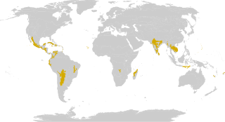
The Global 200 is the list of ecoregions identified by the World Wide Fund for Nature (WWF), the global conservation organization, as priorities for conservation. According to WWF, an ecoregion is defined as a "relatively large unit of land or water containing a characteristic set of natural communities that share a large majority of their species dynamics, and environmental conditions". For example, based on their levels of endemism, Madagascar gets multiple listings, ancient Lake Baikal gets one, and the North American Great Lakes get none.
The tropical and subtropical dry broadleaf forest is a habitat type defined by the World Wide Fund for Nature and is located at tropical and subtropical latitudes. Though these forests occur in climates that are warm year-round, and may receive several hundred centimeters of rain per year, they have long dry seasons that last several months and vary with geographic location. These seasonal droughts have great impact on all living things in the forest.

Tropical and subtropical moist broadleaf forests (TSMF), also known as tropical moist forest, is a subtropical and tropical forest habitat type defined by the World Wide Fund for Nature.

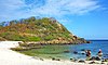
The Malabar Coast moist forests are a tropical moist broadleaf forest ecoregion of southwestern India.

The North Western Ghats moist deciduous forests is a tropical moist broadleaf forest ecoregion of southwestern India.

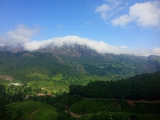
The South Western Ghats moist deciduous forests is an ecoregion in the Western Ghats of southern India with tropical and subtropical moist broadleaf forests. This biome covers the Nilgiri Hills between elevation of 250 and 1,000 m in Kerala, Karnataka and Tamil Nadu states.

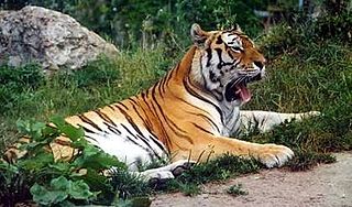
The North Western Ghats montane rain forests is a tropical moist broadleaf forest ecoregion of southwestern Indian peninsula. It covers an area of 30,900 square kilometers (11,900 sq mi), extending down the spine of the Western Ghauts range, from southernmost Gujarat through Damaon, Maharashtra, Goa& Karnataka. The montane rain forests are found above 1000 meters elevation, and are surrounded at lower elevations by the North Western Ghats moist deciduous forests.
The term Malabar rainforests refers to one or more distinct ecoregions recognized by biogeographers:
- the Malabar Coast moist forests formerly occupied the coastal zone to the 250 metre elevation
- the South Western Ghats moist deciduous forests grow at intermediate elevations
- the South Western Ghats montane rain forests cover the areas above 1000 metres elevation
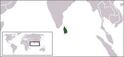
The environment of Sri Lanka is unique in being one of the world's bio-diversity hot-spots.

The Maputaland-Pondoland bushland and thickets is one of the ecoregions of South Africa. It consists of the montane shrubland biome.

The Sri Lanka dry-zone dry evergreen forests are a tropical dry broadleaf forest ecoregion of the island of Sri Lanka.

The Sri Lanka montane rain forests is an ecoregion found above 1,000 m in the central highlands of Sri Lanka. Owing to their rich biodiversity, this region is considered to be a super-hotspot within endemic hotspots of global importance. These forests are cooler than lowland forests and therefore they have ideal conditions for growth of cloud forests. These forests classifications tropical sub montane forest, tropical sub-montane and tropical upper montane. Half of Sri Lanka's endemic flowering plants and 51 percent of the endemic vertebrates are restricted to these forests. More than 34 percent of Sri Lanka's endemic trees, shrubs, and herbs can only be found in this ecoregion. Twisted, stunted trees are a common sight in these forests, together with many varieties of orchids, mosses and ferns. The trees of montane rain forests grow to a height 10–15 meters, shorter than the lowland rain forest trees. These high altitude forests are the catchment area for most of Sri Lanka's major rivers.
All of the animals living in Asia and its surrounding seas and islands are considered the fauna of Asia. Since there is no natural biogeographic boundary in the west between Europe and Asia. The term "fauna of Asia" is somewhat elusive. Temperate Asia is the eastern part of the Palearctic realm, and its south-eastern part belongs to the Indomalayan realm. Asia shows a notable diversity of habitats, with significant variations in rainfall, altitude, topography, temperature and geological history, which is reflected in its richness and diversity of animal life.

Deforestation is one of the most serious environmental issues in Sri Lanka. Sri Lanka's current forest cover as of 2017 was 29.7%. In the 1920s, the island had a 49 percent forest cover but by 2005 this had fallen by approximately 26 percent. Between 1990 and 2000, Sri Lanka lost an average of 26,800 ha of forests per year. This amounts to an average annual deforestation rate of 1.14%. Between 2000 and 2005 the rate accelerated to 1.43% per annum. However, with a long history of policy and laws towards environmental protection, deforestation rates of primary cover have decreased 35% since the end of the 1990s thanks to a strong history of conservation measures. The problem of deforestation in Sri Lanka is not as significant in the southern mountainous regions as it is in northern and lowland southern Sri Lanka, largely due to the nature of environmental protection.

Southwestern Sri Lanka rivers and streams is a freshwater ecoregion in Sri Lanka. The ecoregion is listed in Global 200, a list of ecoregions compiled by the World Wide Fund for Nature for conservation priorities. The extensive network of rivers and streams of Sri Lanka drains a total of 103 distinct natural river basins. Several waterfall habitats have been formed as a result of rivers and streams flowing through high and mid elevation areas. The ecoregion spreads over 15,500 km2 in the wet zone of the southwestern part of Sri Lanka. More than a quarter of the freshwater fishes that have been discovered in Southwestern Sri Lanka rivers and streams are endemic. Nine endemic genera of freshwater fishes of Western Ghats and Sri Lanka hotspot Malpulutta are found only in Sri Lanka. Studies suggest that the number of species still to be discovered is quite high. Until recently wetlands in Sri Lanka were used for drainage, construction sites and land fills.

The Sri Lanka lowland rain forests represents Sri Lanka's Tropical rainforests below 1,000 m (3,281 ft) in elevation in the southwestern part of the island. The year-around warm, wet climate together with thousands years of isolation from mainland India have resulted in the evolution of numerous plants and animal species that can only be found in rain forests in Sri Lanka. The thick forest canopy is made up of over 150 species of trees, some of the emergent layer reaching as high as 45 m (148 ft). The lowland rain forests accounts for 2.14 percent of Sri Lanka's land area. This ecoregion is the home of the jungle shrew, a small endemic mammal of Sri Lanka. Sri Lanka has the highest density of amphibian species worldwide. Many of these, including 250 species of tree frogs, live in these rain forests.

Biogeographic classification of India is the division of India according to biogeographic characteristics. Biogeography is the study of the distribution of species (biology), organisms, and ecosystems in geographic space and through geological time. India has a rich heritage of natural diversity. India ranks fourth in Asia and tenth in the world amongst the top 17 mega-diverse countries in the world. India harbours nearly 11% of the world's floral diversity comprising over 17500 documented flowering plants, 6200 endemic species, 7500 medicinal plants and 246 globally threatened species in only 2.4% of world's land area. India is also home to four biodiversity hotspots—Andaman & Nicobar Islands, Eastern Himalaya, Indo-Burma region, and the Western Ghats. Hence the importance of biogeographical study of India's natural heritage.
Sri Lanka is a relatively small continental island, it exhibits a remarkable diversity of forest types, which are among the biologically one of richest forests in Asia. In these forests plant species show extraordinary patterns of localized distribution. Sri Lanka's forest became one of highest density of species diversity in the world. Sri Lanka natural forest cover about 12,493 km2 29.46% According to the National Red List said, Sri Lanka counts 253 land species, 245 species of butterflies, 240 birds, 211 reptiles, 748 evaluated vertebrates and 1,492 invertebrates. Forest coverage is about 70% tropical dry monsoon forests, 15% tropical moist monsoon forests and 5% tropical lower montane forests. By the dawn of the 19th century, Sri Lanka's forest cover was estimated at up to 70% of the total land area. Since then, the forest cover has decreased progressively over time. Significant loss of Sri Lanka's forest cover was first reported in the 19th century, with the introduction of plantation agricultural crops such as tea and vegetables. Commercial timber extraction policy of colonial rulers (British colonial time also led to clearing of forests in the dry zone. Irrigation development and agricultural expansions have been identified as key drivers of forest cover change.