Related Research Articles

The Euphrates is the longest and one of the most historically important rivers of Western Asia. Together with the Tigris, it is one of the two defining rivers of Mesopotamia. Originating in Turkey, the Euphrates flows through Syria and Iraq to join the Tigris in the Shatt al-Arab, which empties into the Persian Gulf.

The geography of Iraq is diverse and falls into five main regions: the desert, Upper Mesopotamia, the northern highlands of Iraq, Lower Mesopotamia, and the alluvial plain extending from around Tikrit to the Persian Gulf.

Kuwait is a country in West Asia, bordering the Persian Gulf, between Iraq and Saudi Arabia. Kuwait is located at the far northwestern corner of the Persian Gulf. Kuwait is 17,820 square kilometres in size. At its most distant points, it is about 200 km (120 mi) north to south, and 170 km (110 mi) east to west. Kuwait has 10 islands. Kuwait's area consists mostly of desert.

The Sahara desert, as defined by the World Wide Fund for Nature (WWF), includes the hyper-arid center of the Sahara, between latitudes 18° N and 30° N. It is one of several desert and xeric shrubland ecoregions that cover the northern portion of the African continent.
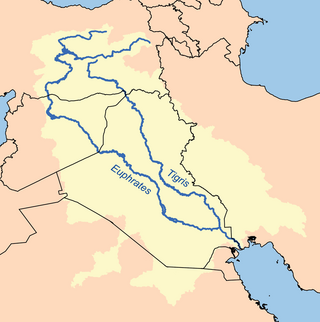
The Tigris is the eastern of the two great rivers that define Mesopotamia, the other being the Euphrates. The river flows south from the mountains of the Armenian Highlands through the Syrian and Arabian Deserts, and empties into the Persian Gulf.
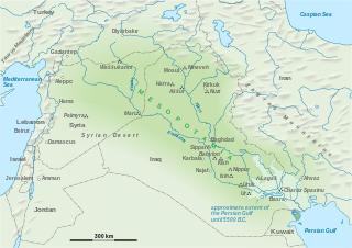
The geography of Mesopotamia, encompassing its ethnology and history, centered on the two great rivers, the Tigris and Euphrates. While the southern is flat and marshy, the near approach of the two rivers to one another, at a spot where the undulating plateau of the north sinks suddenly into the Babylonian alluvium, tends to separate them still more completely. In the earliest recorded times, the northern portion was included in Mesopotamia; it was marked off as Assyria after the rise of the Assyrian monarchy. Apart from Assur, the original capital of Assyria, the chief cities of the country, Nineveh, Kalaḫ and Arbela, were all on the east bank of the Tigris. The reason was its abundant supply of water, whereas the great plain on the western side had to depend on streams flowing into the Euphrates.
The Tigris–Euphrates river system is a large river system in Western Asia that discharges into the Persian Gulf. Its principal rivers are the Tigris and Euphrates, along with smaller tributaries.

The Zagros Mountains are a long mountain range in Iran, northern Iraq, and southeastern Turkey. This mountain range has a total length of 1,600 km (990 mi). The Zagros mountain range begins in northwestern Iran and roughly follows Iran's western border while covering much of southeastern Turkey and northeastern Iraq. From this border region, the range continues to the southeast under also the waters of the Persian Gulf. It spans the southern parts of the Armenian highland, the whole length of the western and southwestern Iranian plateau, ending at the Strait of Hormuz. The highest point is Mount Dena, at 4,409 metres (14,465 ft).
The wildlife of Iraq includes its flora and fauna and their natural habitats. Iraq has multiple biomes from mountainous region in the north to the wet marshlands along the Euphrates river. The western part of the country is mainly desert and some semi-arid regions. As of 2001, seven of Iraq's mammal species and 12 of its bird species were endangered. The endangered species include the northern bald ibis and Persian fallow deer. The Syrian wild ass is extinct, and the Saudi Arabian dorcas gazelle was declared extinct in 2008.

The Mesopotamian Marshes, also known as the Iraqi Marshes, are a wetland area located in Southern Iraq and southwestern Iran as well as partially in northern Kuwait. The marshes are primarily located on the floodplains of the Euphrates and Tigris rivers bound by the cities of Basra, Nasiriyah, Amarah and a portion of southwestern Iran and northern Kuwait. Historically the marshlands, mainly composed of the separate but adjacent Central, Hawizeh and Hammar Marshes, used to be the largest wetland ecosystem of Western Eurasia. The unique wetland landscape is home to the Marsh people, who have developed a unique culture tightly coupled to the landscape – harvesting reeds and rice, fishing and herding water buffalo.

The Hyrcanian forests are a zone of lush lowland and montane forests covering about 55,000 square kilometres (21,000 sq mi) near the shores of the Caspian Sea in Iran and Azerbaijan. The forest is named after the ancient region of Hyrcania. The World Wide Fund for Nature refers to the ecoregion as the Caspian Hyrcanian mixed forests. Since 5 July 2019, the Hyrcanian Forests have been designated a UNESCO World Heritage Site. In September 2023, the heritage site expanded to incorporate portions of the forest located in Azerbaijan.

Theora mesopotamica is a species of saltwater and brackish water clam, a bivalve mollusk in the family Semelidae. This species is known from the northwestern end of the Persian Gulf, and from subfossil remains in brackish deposits in the lower Tigris–Euphrates basin of Iraq.
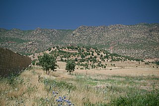
The Middle East steppe ecoregion stretches in an arc from southern Jordan across Syria and Iraq to the western border of Iran. The upper plains of the Tigris and Euphrates Rivers dominate most of the ecoregion. The terrain is mostly open shrub steppe. The climate is arid. Evidence is that this region was once more of a forest-steppe, but centuries of overgrazing and gathering firewood have reduced tree and grass cover to small areas and along the riverine corridors. Despite the degraded condition of the steppe environment, the ecoregion is important for water birds as the rivers and reservoirs provide habitat in the arid region.

The Persian Gulf desert and semi-desert ecoregion covers the desert coastal plain of the northwest Persian Gulf, that is, on the northeast Arabian Peninsula, from Kuwait in the north to a small coastal sector in the United Arab Emirates to the southeast.
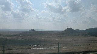
The Mesopotamian shrub desert is a deserts and xeric shrublands ecoregion in Western Asia. It extends across portions of Israel, Jordan, Syria, Iraq, and Iran.
References
- ↑ Olson, D. M., Dinerstein, E., Wikramanayake, E. D., Burgess, N. D., Powell, G. V. N., Underwood, E. C., D'Amico, J. A., Itoua, I., Strand, H. E., Morrison, J. C., Loucks, C. J., Allnutt, T. F., Ricketts, T. H., Kura, Y., Lamoreux, J. F., Wettengel, W. W., Hedao, P., Kassem, K. R. (2001). Terrestrial ecoregions of the world: a new map of life on Earth. Bioscience 51(11):933-938