Brackish water, sometimes termed brack water, is water occurring in a natural environment that has more salinity than freshwater, but not as much as seawater. It may result from mixing seawater and fresh water together, as in estuaries, or it may occur in brackish fossil aquifers. The word comes from the Middle Dutch root brak. Certain human activities can produce brackish water, in particular civil engineering projects such as dikes and the flooding of coastal marshland to produce brackish water pools for freshwater prawn farming. Brackish water is also the primary waste product of the salinity gradient power process. Because brackish water is hostile to the growth of most terrestrial plant species, without appropriate management it can be damaging to the environment.
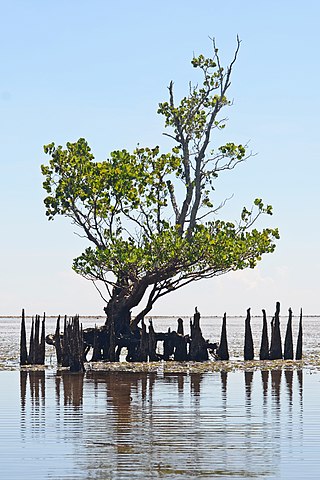
A mangrove is a shrub or tree that grows mainly in coastal saline or brackish water. Mangroves grow in an equatorial climate, typically along coastlines and tidal rivers. They have particular adaptations to take in extra oxygen and remove salt, allowing them to tolerate conditions that kill most plants. The term is also used for tropical coastal vegetation consisting of such species. Mangroves are taxonomically diverse due to convergent evolution in several plant families. They occur worldwide in the tropics and subtropics and even some temperate coastal areas, mainly between latitudes 30° N and 30° S, with the greatest mangrove area within 5° of the equator. Mangrove plant families first appeared during the Late Cretaceous to Paleocene epochs and became widely distributed in part due to the movement of tectonic plates. The oldest known fossils of mangrove palm date to 75 million years ago.

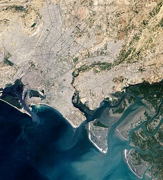
An estuary is a partially enclosed coastal body of brackish water with one or more rivers or streams flowing into it, and with a free connection to the open sea. Estuaries form a transition zone between river environments and maritime environments and are an example of an ecotone. Estuaries are subject both to marine influences such as tides, waves, and the influx of saline water, and to fluvial influences such as flows of freshwater and sediment. The mixing of seawater and freshwater provides high levels of nutrients both in the water column and in sediment, making estuaries among the most productive natural habitats in the world.
An aquatic ecosystem is an ecosystem found in and around a body of water, in contrast to land-based terrestrial ecosystems. Aquatic ecosystems contain communities of organisms—aquatic life—that are dependent on each other and on their environment. The two main types of aquatic ecosystems are marine ecosystems and freshwater ecosystems. Freshwater ecosystems may be lentic ; lotic ; and wetlands.

Mangrove forests, also called mangrove swamps, mangrove thickets or mangals, are productive wetlands that occur in coastal intertidal zones. Mangrove forests grow mainly at tropical and subtropical latitudes because mangrove trees cannot withstand freezing temperatures. There are about 80 different species of mangroves, all of which grow in areas with low-oxygen soil, where slow-moving waters allow fine sediments to accumulate.

Rhizophora mangle, also known as the red mangrove, is a salt-tolerant, small-to-medium sized evergreen tree restricted to coastal, estuarine ecosystems along the southern portions of North America, the Caribbean as well as Central America and tropical West Africa. Its viviparous "seeds", in actuality called propagules, become fully mature plants before dropping off the parent tree. These are dispersed by water until eventually embedding in the shallows.

Marine ecosystems are the largest of Earth's aquatic ecosystems and exist in waters that have a high salt content. These systems contrast with freshwater ecosystems, which have a lower salt content. Marine waters cover more than 70% of the surface of the Earth and account for more than 97% of Earth's water supply and 90% of habitable space on Earth. Seawater has an average salinity of 35 parts per thousand of water. Actual salinity varies among different marine ecosystems. Marine ecosystems can be divided into many zones depending upon water depth and shoreline features. The oceanic zone is the vast open part of the ocean where animals such as whales, sharks, and tuna live. The benthic zone consists of substrates below water where many invertebrates live. The intertidal zone is the area between high and low tides. Other near-shore (neritic) zones can include mudflats, seagrass meadows, mangroves, rocky intertidal systems, salt marshes, coral reefs, lagoons. In the deep water, hydrothermal vents may occur where chemosynthetic sulfur bacteria form the base of the food web.
The Florida mangroves ecoregion, of the mangrove forest biome, comprise an ecosystem along the coasts of the Florida peninsula, and the Florida Keys. Four major species of mangrove populate the region: red mangrove, black mangrove, white mangrove, and the buttonwood. The mangroves live in the coastal zones in the more tropical southern parts of Florida; mangroves are particularly vulnerable to frosts. Mangroves are important habitat as both fish nursery and brackish water habitats for birds and other coastal species.
Jaffna Lagoon is a large lagoon off Jaffna District and Kilinochchi District, northern Sri Lanka. The lagoon is surrounded by the densely populated Jaffna Peninsula containing palmyra palms, coconut plantations, and rice paddies. There are numerous fishing villages and some salt pans. The lagoon has extensive mudflats, seagrass beds and some mangroves. The lagoon attracts a wide variety of water birds including American flamingoes, ducks, gulls, terns and other shorebirds.

The tall-stilt mangrove belongs to the Plantae kingdom under the Rhizophoraceae family. R. apiculata is distributed throughout Southeast Asia and the western Pacific islands.

Before drainage, the Everglades, a region of tropical wetlands in southern Florida, were an interwoven mesh of marshes and prairies covering 4,000 square miles (10,000 km2). The Everglades is both a vast watershed that has historically extended from Lake Okeechobee 100 miles (160 km) south to Florida Bay, and many interconnected ecosystems within a geographic boundary. It is such a unique meeting of water, land, and climate that the use of either singular or plural to refer to the Everglades is appropriate. When Marjory Stoneman Douglas wrote her definitive description of the region in 1947, she used the metaphor "River of Grass" to explain the blending of water and plant life.
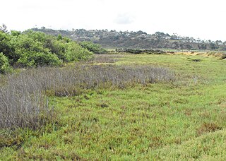
Brackish marshes develop from salt marshes where a significant freshwater influx dilutes the seawater to brackish levels of salinity. This commonly happens upstream from salt marshes by estuaries of coastal rivers or near the mouths of coastal rivers with heavy freshwater discharges in the conditions of low tidal ranges.
Classification of wetlands has been a problematical task, with the commonly accepted definition of what constitutes a wetland being among the major difficulties. A number of national wetland classifications exist. In the 1970s, the Ramsar Convention on Wetlands of International Importance introduced a first attempt to establish an internationally acceptable wetland classification scheme.

Coastal fish, also called inshore fish or neritic fish, inhabit the sea between the shoreline and the edge of the continental shelf. Since the continental shelf is usually less than 200 metres (660 ft) deep, it follows that pelagic coastal fish are generally epipelagic fish, inhabiting the sunlit epipelagic zone. Coastal fish can be contrasted with oceanic fish or offshore fish, which inhabit the deep seas beyond the continental shelves.

Mangrove ecosystems represent natural capital capable of producing a wide range of goods and services for coastal environments and communities and society as a whole. Some of these outputs, such as timber, are freely exchanged in formal markets. Value is determined in these markets through exchange and quantified in terms of price. Mangroves are important for aquatic life and home for many species of fish.
The Indus River Delta-Arabian Sea mangroves are a large mangrove ecoregion on the Arabian Sea coast of Sindh Province, Pakistan, and the Gulfs of Kutch and Khambhat in Gujarat, India. The mangroves are the seventh largest mangrove forest in the world.

A marine habitat is a habitat that supports marine life. Marine life depends in some way on the saltwater that is in the sea. A habitat is an ecological or environmental area inhabited by one or more living species. The marine environment supports many kinds of these habitats.

Koggala Lagoon is a coastal body of water located in Galle District, Southern Sri Lanka. It is situated near the town of Koggala and adjacent to the southern coast, about 110 km (68 mi) south of Colombo. The lagoon is embellished with eight ecologically rich small islands.

Rekawa Lagoon is a coastal waterbody located in Hambantota Districtt in the Southern Province, Sri Lanka and it is located 200 km (120 mi) south of Colombo. The lagoon possesses a rich biodiversity with a variety of flora and fauna.
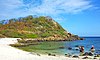
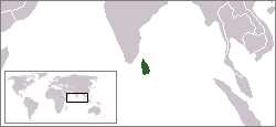
Sri Lanka exhibits a remarkable biological diversity and is considered to be the richest country in Asia in terms of species concentration.