Guianan mangroves

Last updated
Guianan mangroves (NT1411)
Laguna de Ajies o cano de Ajies.jpg
Ecoregion NT1411.png
Ecoregion territory (in red)
Ecology
Realm Neotropical
Biome Mangrove
Geography
Area14,500 km2 (5,600 sq mi)
Countries French Guiana, Suriname, Guyana, Venezuela
Coordinates 5°58′55″N55°38′13″W / 5.982°N 55.637°W / 5.982; -55.637 Coordinates: 5°58′55″N55°38′13″W / 5.982°N 55.637°W / 5.982; -55.637
Climate typeAf: equatorial, fully humid

The Guianan mangroves (NT1411) is a coastal ecoregion of southeastern Venezuela, Guyana, Suriname and French Guiana. The mangroves provide an important habitat for migrating birds that winter in the area. Large areas are intact, although they are threatened by destruction of the trees for timber and to make way for agriculture, and from upstream agricultural and industrial pollution.

Contents

Location

South America laea relief location map.jpg
Red pog.svg
Location in South America

The Guianan mangroves ecoregion extends along the Atlantic coasts of southeastern Venezuela, Guyana, Suriname and French Guiana. It covers an area of about 14,500 square kilometres (5,600 sq mi) between the deltas of the Orinoco and Oyapock rivers. It includes the Gulf of Paria and the delta of the San Juan River. The largest part is in Venezuela in and around the Orinoco delta. [1]

The mangroves lie between the sea and areas of Orinoco Delta swamp forests, Guianan moist forests and Guianan freshwater swamp forests. [2] The Guianan mangroves ecoregion is part of the 31,855 square kilometres (12,299 sq mi) Guianan-Amazon Mangroves global ecoregion, which also contains the Amapa mangroves, Pará mangroves and Maranhão mangroves ecoregions. [3]

Physical

Elevations in the flat, narrow strip of coastal land covered by the mangroves range from sea level to about 4 metres (13 ft) above sea level. Sand and shell ridges and elevated mud flats are formed by accumulated sediments, carried steadily westward from the mouth of the Amazon by strong ocean currents. The mud flats evolve into clay flats occupied by some species of mangrove. The coastlines suffer periodically from extensive erosion after large number of mangroves die at the same time. Other habitats are brackish or salt lagoons, brackish herbaceous swamps, swamp woods and swamp forests. The swamps are a source of fresh water to the mangroves. [1]

The alluvial plains in the northwest have different characteristics. The San Juan delta has swamps with marine-fluvial sediment deposits, the Gulf of Paria has marine sediments and the Orinoco delta has mainly fluvial sediments. The tides are no more than 1.3 metres (4 ft 3 in) in the Orinoco delta. The Oronoco river has an average flow of 36,000 cubic metres (1,300,000 cu ft) per second, and deposits 200,000 tons of sediment each year, resulting in a very unstable landscape. [1]

Climate

There are considerable differences in climate along the length of the ecoregion. Annual rainfall varies from 960 millimetres (38 in) in Venezuela to the east of the Gulf of Paria to 3,054 millimetres (120.2 in) in parts of Suriname. Some areas have a four-month dry season while others have none. In the Orinoco Delta the mean monthly temperature ranges from 25.4 to 27.2 °C (77.7 to 81.0 °F). [1]

Flora

The composition of the mangrove forests depend on the soil and the salinity of the water. Mixed stands of Rhizophora and Avicennia species are found in areas of higher salinity, particularly in the extreme northwest. Rhizophora and Laguncularia species grow in channels with more fresh water, and Rhizophora, Avicennia and Laguncularia grow where the soil contains more organic matter. The higher zones hold forests dominated by Avicennia species while herbaceous vegetation grows in the more saline swamps. [1]

There are diverse habitats in the Orinoco delta. The most saline parts have formations of Rhizophora mangle , Rhizophora harrisonii and Rhizophora racemosa . In less saline areas further inland Rhizophora species and the palm Mauritia flexuosa grow together in peat bogs. In other parts of the delta the Rhizophora species mingle with swamp forest species such as Pterocarpus officinalis , Symphonia globulifera , açaí palm (Euterpe oleracea) and Roystonea species. There are wide belts of Rhizophora in the inner estuary, with Avicennia on higher ground, sometimes mixed with Pterocarpus officinalis, Symphonia globulifera and Vitex species. [1]

Beach in Kourou, French Guiana, where it starts to turn into a mangrove Kourou beach mangrove shore 2.jpg
Beach in Kourou, French Guiana, where it starts to turn into a mangrove

Along the coast from eastern Venezuela to the Guyanas the mangroves form belts a few meters wide associated with deciduous forests, muddy meadows and muddy forests in flooded areas. Dominant species include Costus arabicus , Cyperus giganteus , Eichhornia crassipes , Heliconia psittacorum , Roystonea regia and Mauritia flexuosa . Muddy forests on ground that is almost always flooded have a single dense stratum of trees with heights from 15 to 25 metres (49 to 82 ft) such as Pterocarpus officinalis, Symphonia globulifera, Tabebuia aquatilis , açaí palm (Euterpe oleracea), Manicaria species and Mauritia flexuosa . The mangrove belts hold Laguncularia racemosa on the seaward side, mixed with Spartina species of salt marsh grass, in front of stands of Avicennia germinans . [1]

Fauna

scarlet ibis (Eudocimus ruber) Scarlet Ibis - Corocoro Colorado (Eudocimus ruber) (12447024144).jpg
scarlet ibis (Eudocimus ruber)

The ecoregion has diverse fauna. It is the largest area in South America where migrating shorebirds from the Nearctic realm spend the winter, with up to 5 million birds visiting in one year. Over 118 species of birds have been recorded in Suriname and Venezuela, of which more than 70 are waterbirds. Bird species include scarlet ibis (Eudocimus ruber), black skimmer (Rynchops niger), gull-billed tern (Gelochelidon nilotica), short-billed dowitcher (Limnodromus griseus), lesser yellowlegs (Tringa flavipes), greater yellowlegs (Tringa melanoleuca), black-bellied whistling duck (Dendrocygna autumnalis) and tricolored heron (Egretta tricolor). [1]

More than 50 species of mammals have been recorded, including opossums, bats, tufted capuchin (Sapajus apella), common squirrel monkey (Saimiri sciureus), Venezuelan red howler (Alouatta seniculus), white-faced saki (Pithecia pithecia), giant anteater (Myrmecophaga tridactyla), jaguar (Panthera onca), cougar (Puma concolor), ocelot (Leopardus pardalis) and capybara (Hydrochoerus hydrochaeris). The paradoxal frog ( Pseudis paradoxa ) and the common Suriname toad (Pipa pipa) have adapted to the saline conditions. [1] Reptiles include olive ridley sea turtle (Lepidochelys olivacea), which nests on the beaches, green iguana (Iguana iguana), spectacled caiman (Caiman crocodilus) and green anaconda (Eunectes murinus).

Status

The World Wildlife Fund gives the ecoregion the status of "Relatively Stable/Intact". [1] There are many protected areas, and large sections of mangroves are intact. Suriname has at least seven protected areas, most with a degree of connectivity, including the Coppename Monding wetland and the Wia-Wia nature reserve. Venezuela has the 2,650 square kilometres (1,020 sq mi) Mariusa National Park and the 8,765 square kilometres (3,384 sq mi) Orinoco Delta Biosphere Reserve. The Guarapiche Forest Reserve in the San Juan delta holds a 45,000 hectares (110,000 acres) patch of mangroves, palms and swamp forests. [1]

Agriculture such as rice cultivation has caused some fragmentation, but most fragmentation is natural. The main threats come from logging to obtain building material, fuel, tannin and medicinal products. Upstream agriculture releases fertilizers and pesticides, and adds sediments due to erosion. Population growth and tourism are increasing use of the mangroves as a source of food such as shrimp and wildlife, or for grazing domestic animals. Unsuccessful hydraulic engineering has damaged the Orinoco delta environment, and oil prospecting is a concern. [1]

Related Research Articles

Orinoco Delta

The Orinoco Delta is a vast river delta of the Orinoco River, located in eastern Venezuela.

Maranhão mangroves Mangrove ecoregion of northern Brazil

The Maranhão mangroves is a mangrove ecoregion of northern Brazil. It supports half of the shorebird population of the country. The combination of flat land, heavy rainfall and high tides causes the mangroves to extend up to 40 kilometres (25 mi) inland, where they are interspersed with other rainforest species.

Guianan savanna

The Guianan savanna (NT0707) is an ecoregion in the south of Venezuela, Guyana and Suriname and the north of Brazil. It is in the Amazon biome. The savanna covers an area of rolling upland plains on the Guiana Shield between the Amazon and Orinoco basins. It includes forested areas, but these are shrinking steadily due to the effect of frequent fires, either accidental or deliberate. The ecoregion includes the Gran Sabana region of Venezuela.

Marajó várzea

The Marajó várzea (NT0138) is an ecoregion of seasonally and tidally flooded várzea forest in the Amazon biome. It covers a region of sedimentary islands and floodplains at the mouth of the Amazon that is flooded twice daily as the ocean tides push the river waters onto the land. The flooded forests provide food for a wide variety of fruit-eating fish, aquatic mammals, birds and other fauna. It has no protected areas and is threatened by cattle and water-buffalo ranching, logging and fruit plantations.

Guianan Highlands moist forests

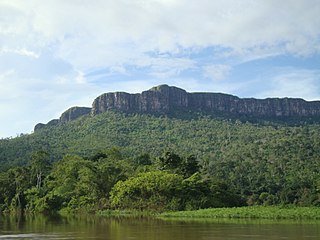
The Guayanan Highlands moist forests (NT0124) is an ecoregion in the south of Venezuela and the north of Brazil and in Guyana, Suriname, French Guiana. It is in the Amazon biome. It encompasses an upland region with diverse fauna and flora, which contains dramatic tepuis, or sandstone table mountains. The region has been inaccessible in the past and is generally fairly intact, apart from the north and northeast where large scale agriculture, ranching and mining operations are steadily encroaching on the ecosystem. New roads are opening the interior to logging, and planned dams will have a drastic impact on the riparian zones.

Guianan moist forests

The Guianan moist forests (NT0125) is an ecoregion in the east of Venezuela, north of Brazil and the Guyanas. It is in the Amazon biome. The climate is hot and humid, with two rainy seasons each year. As of 1996 the tropical rainforest habitat was relatively intact, although there were mounting threats from illegal logging and gold mining.

Amazon–Orinoco–Southern Caribbean mangroves

The Amazon–Orinoco–Southern Caribbean mangroves (NT1401) is an ecoregion along the coasts of Colombia, Venezuela, Guyana, Suriname, French Guiana and Brazil.

Orinoco Delta swamp forests

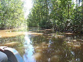
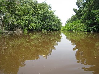
The Orinoco Delta swamp forests (NT0147) is an ecoregion of eastern Venezuela and northern Guyana covering the large and shifting Orinoco Delta. The vegetation is mostly permanently flooded rainforest. The ecoregion is relatively intact apart from a large area that was damaged by a failed flood control program in the 1960s. It is inaccessible, so logging is difficult, and the soil is unsuitable for farming. The main threat comes from oil exploration, which would bring an influx of settlers into the delta.

Orinoco wetlands

The Orinoco wetlands (NT0906) is an ecoregion of northeast Venezuela within the northern Orinoco Delta. It holds areas of tall grasses in flooded land, surrounded by mangroves and swamp forest, giving way to the drier Llanos savanna in the west.

Amapá mangroves

The Amapá mangroves (NT1402) is an ecoregion along the Atlantic coast of the state of Amapá in Brazil. The low coastal plain has been formed from recent sedimentation, including sediments deposited by the rivers and sediments carried northward from the mouth of the Amazon River by strong currents and deposited by the tides. The extensive mangroves grow on the newly formed coastal mudflats and along the edges of estuaries. They merge into freshwater várzea flooded forests further inland. The ecoregion is generally well-preserved, although excessive extraction of natural resources including timber and shrimps is a concern.

Pará mangroves

The Pará mangroves (NT1427) is an ecoregion along the Atlantic coast of the state of Pará in Brazil. They constitute the western extension of the Maranhão mangroves ecoregion. The mangroves are relatively intact, although they are under some pressure from agriculture and logging.

Paramaribo swamp forests

The Paramaribo swamp forests (NT0149) is an ecoregion in the coastal plain of Suriname covering a strip of land that is almost always flooded by fresh waters. It transitions into saline mangrove swamps towards the coast, and into submontane forests towards the interior.

Mesoamerican Gulf–Caribbean mangroves

The Mesoamerican Gulf-Caribbean mangroves ecoregion covers the series of disconnected mangrove habitats along the eastern coast of Central America. These salt-water wetlands are found in river deltas, lagoons, and low-lying areas facing the Gulf of Mexico and Caribbean Sea, from Tampico, Mexico to central Panama. The mangroves are areas of high biodiversity and endemism. Many of the sites are protected as national parks or nature reserves.

Coastal Venezuelan mangroves

The Coastal Venezuelan mangroves ecoregion covers the salt-water mangrove forests along the Caribbean Sea and Atlantic Ocean coast of Venezuela, from Cocinetas Basin to the edge of the Caño Manamo River and the Orinoco Delta in the east. It is one of the largest mangrove ecoregions in South America, with an area of 5,698 km2, and stretching across over 400 km of Venezuelan coastline.

Lesser Antilles mangroves

The Lesser Antilles mangroves ecoregion covers the salt-water habitats along the coasts of the islands on the divide between the Caribbean Sea and the Atlantic Ocean. the included islands stretch from Anguilla in the north to the island of Grenada in the south. The species diversity of these small islands is less than that of the larger islands of the Greater Antilles with to the west, but endemism is high due to the relative isolation of the different islands.

Magdalena–Santa Marta mangroves

The Magdalena-Santa Marta mangroves ecoregion covers the mangrove forests along the coast of Colombia on the Caribbean Sea, from Gulf of Urabá in the west at the Colombia-Panama border to the Guajira Peninsula in the east. The region is relatively dry, with low precipitation and high evapotranspiration, so the mangroves depend for water and nutrients on the rivers flowing across the estuarine plain from the Sierra Nevada de Santa Marta mountains to the east. Efforts are currently underway to restore mangroves degraded by development and road building from the 1950s to 1980s.

Trinidad mangroves Ecoregion in Trinidad

The Trinidad mangroves ecoregion covers the separate mangrove forest areas on the coast of the island of Trinidad, in the country of Trinidad and Tobago. The character of the mangroves is affected by the large amount of fresh water flowing out of the Orinoco River and Amazon River to the south, which flow northwest around the island. The mangroves of Trinidad are found on all coasts, and are usually in the estuaries of rivers, but also found in coastal lagoons.

Usumacinta mangroves

The Usumacinta mangroves ecoregion covers the mangrove forests ont the Gulf Coast of Mexico, around the margins of the Laguna de Términos. The "Ends" in the name refer to the mouths of the rivers that empty into the lagoon, including the Usumacinta River. This region, which is due south of the mouth of the Mississippi River across the Gulf of Mexico, receives an estimated one-third of the wintering birds migrating on the Mississippi Flyway. It is estimated that the lagoon supports 90 endangered species.

References

  1. 1 2 3 4 5 6 7 8 9 10 11 12 Tognetti, Burdette & Schipper.
  2. WildFinder – WWF.
  3. Guianan-Amazon Mangroves – WWF Global.

Sources