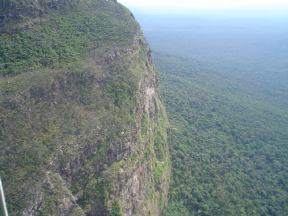
Serranía de la Macarena is an isolated mountain range located in the Meta Department, Colombia. It was named after the Virgin of Hope of Macarena. The mountains are separated by about 40 km (25 mi) at their northern extreme from the East Andes. The range is orientated from north to south and is 120 km (75 mi) in length and 30 km (19 mi) wide. The highest peak reaches 2,615 m (8,579 ft) and is the highest point of the Orinoquía Region. The first national reserve in Colombia was established in the central part of the mountain range in accordance with a Congressional Law promulgated in 1948. The status of National Natural Park was designated in 1971 and the protected area encompasses 6,200 km2 (2,400 sq mi).
The Tamá National Natural Park is a national park located in the Tamá Massif of the Andean Region of Colombia, between the municipalities Toledo and Herrán, in the department of Norte de Santander, in the northeastern part of the Eastern Ranges of the Colombian Andes. One of the main attractions of the park is a 820-metre-high (2,690 ft) waterfall, one of the world's highest.

The Tapo-Caparo National Park, or National Park Tapo Caparo, is a protected area with national park status in Venezuela. The park covers 2,050 square kilometres (790 sq mi) in the western states of Barinas, Mérida, and Táchira.

Tirgua National Park, also known as General Manuel Manrique National Park, is a national park in Venezuela. It protects the headwaters of several waterways, especially the river Tirgua, which gives its name to the park.
The Río Viejo San Camilo National Park, or Rio Viejo-San Camilo National Park, Is a protected area with the status of national park in the South American country of Venezuela. Specifically its territory is part of the state of Apure near the border with Colombia. It has an estimated area of 80,000 hectares, which constitute national park since 1 July 1993.
The Ciénagas del Catatumbo National Park Also Catatumbo Marshes National Park or Ciénagas de Juan Manuel National Park Is a protected area of Venezuela.

The Turuépano National Park Is a protected area with national park status in the South American country of Venezuela, located in the Benítez, Cajigal, Libertador and Mariño municipalities in the eastern part of Sucre State, north of the San Juan River and in front of the Gulf of Paria.

The Dinira National Park is a protected area with the national park status located between the states Lara, Portuguesa and Trujillo in the South American country of Venezuela. It was created on November 30, 1988.

The Península de Paria National Park, or Peninsula of Paria National Park, Is a national park on Paria Peninsula in Venezuela.
The Yapacana National Park is a protected area with the status of national park in the South American country of Venezuela. It was formed on December 12, 1978 by executive decree of President Carlos Andres Perez. It is located southwest of the confluence of the Ventuari River on the Orinoco River, in the jurisdiction of the Atabapo municipality of Amazonas state.

The Terepaima National Park Is a protected area with the status of national park in the South American country of Venezuela located in the mountainous region of the Lara and Portuguesa States. Specifically southeast of the city of Barquisimeto, capital of the Lara State, it covers areas belonging to the municipalities Iribarren, Palavecino and Simón Planas.

The Aguaro-Guariquito National Park, also rendered as Aguaro Guariquito National Park, is a protected area with the status of national park in the South American country of Venezuela. Located in the region of the Llanos, it extends over the municipalities of Francisco de Miranda and Jose Rondon in Guárico state.

The Cerro El Copey National Park Also Cerro El Copey-Jóvito Villalba National Park Is a protected area with the status of a national park located to the east of the Caribbean island of Margarita, in the highest mountainous region of Nueva Esparta State in Venezuela.

The Laguna de Tacarigua National Park, also known as Tacarigua Lagoon National Park, is a protected area with the status of a national park located east of Miranda State, close to the town of Laguna de Tacarigua in the South American country of Venezuela. It comprises a permanent coastal lagoon of 7800 ha and 1.2 m of average depth, separated from the sea by a restinga or coastal barrier of 28.8 km long and 300–1000 m wide that was formed by the action of the sea current which runs along the coast in an East-West direction.

The Macarao National Park Is a protected area with the status of a national park located in the Macarao, San Pedro and Jarillo rivers, in the north of the South American country of Venezuela. Its extension of 15,000 hectares covers part of the Capital District and Miranda State. The area was declared National Park in 1973.

The Yurubí National Park is a protected area with the status of national park in the north of the South American country of Venezuela. It was founded on March 18, 1960 in Yaracuy State created to protect the Yurubí river basin, which is the source of fresh water for the city of San Felipe. The Yurubí National Park is located in the mountains of the Sierra de Aroa. The park includes cloud forests and low montane forests and is surrounded by cultivated areas. The park is crossed by small trails, which are used mainly by poachers or by a small number of visitors and researchers. The park is not inhabited; The former settlers of the area were relocated many years ago.

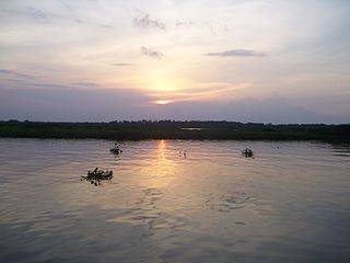
The Orinoco wetlands (NT0906) is an ecoregion of northeast Venezuela within the northern Orinoco Delta. It holds areas of tall grasses in flooded land, surrounded by mangroves and swamp forest, giving way to the drier Llanos savanna in the west.

The Tamá Massif is a group of mountains on the border between Colombia and Venezuela to the south of Lake Maracaibo. It contains evergreen rainforest and cloud forest at the lower levels, and páramos at the highest levels.

The Caura National Park is a protected area with the status of National Park in Venezuela. With an area of 7,534,000 ha. (75,340 km2) it is the largest park in the country and the most recently created (2017).

