Southern Annamites montane rain forests

Last updated
Southern Annamites montane rain forests
Thung lung tinh yeu.JPG
"Valley of Love", near Da Lat, Vietnam
Ecoregion IM0152.png
Ecoregion territory (in purple)
Ecology
Realm Indomalayan
Biome Tropical and subtropical moist broadleaf forests
Borders
Geography
Area46,620 km2 (18,000 sq mi)
Country Vietnam, Laos, Cambodia
Coordinates 12°00′N108°30′E / 12°N 108.5°E / 12; 108.5
Conservation
Protected19.65% [1]

The Southern Annamites montane rain forests ecoregion (WWF ID: IM0152) covers a region of high biodiversity in the central and southern mountains of the Annamite Range in Vietnam. Terrain ranges from wet lowland forest to evergreen hardwood and conifer montane rain forest. [2] [3] [1] There is a short dry season centered on January–February, but fog and dew are common throughout the year and support a lush forest character.

Contents

Location and description

The ecoregion consists of two main sections. The northern section begins south of the Lao Bao Pass, and extends south along the central Annamites to the Ba River valley. This northern sector around the Kontum Massif is a complex of granite mountains, and includes Ngọc Linh, the highest peak in Vietnam at 2,598 metres (8,524 ft). It also includes the Bolaven Plateau in southern Laos, which just west of the main chain of the Annamites.

The southern section is in the south of Vietnam around the Đà Lạt Plateau, which has a highest point of 2,200 metres (7,200 ft). The southern mountains are of weathered basalt, which creates fertile soil for agriculture. [2]

Climate

The climate of the ecoregion is Tropical savanna climate - dry winter (Köppen climate classification (Aw)). This climate is characterized by relatively even temperatures throughout the year, and a pronounced dry season. The driest month has less than 60 mm of precipitation, and is drier than the average month. [4] [5] In this ecoregion, annual precipitation is 1,800-2,000 mm in the Annamites and in the western regions of the Da Lat Plateau, but can reach over 3,000 mm/year on the eastern edge of the Da Lat Plateau.

Flora

The region is about 75% forested. Most of this is a closed forest of broadleaf evergreens and some needle-leaf evergreens. [2] Wet evergreen forest covers from 600 to 900 meters elevation is characterized by species of Fagaceae, Myrtaceae, and Lauraceae. Above 900 meters, the wet hardwood forest supports a wide variety of tree species, generally dependent on the geology and soil of the location. The canopy of about 30 meters is lower at higher elevations and with thinner soils. [2] Epiphytes are a common feature of these forests. Khasi pine ( Pinus kesiya ) is common throughout the region at elevations up to 1,800 meters, particularly in drier areas.

Pinus krempfii and Pinus dalatensis are endemic to the ecoregion, with P. krempfii found only on the Da Lat Plateau, and P. dalatensis on the Da Lat Plateau and several smaller massifs to the north. Both are emergent trees growing 25 meters or more in height above humid montane broadleaf evergreen forest. Pinus krempfii grows in closed-canopy evergreen forests of Castanopsis chinensis, Trigonobalanus verticillata, Engelhardia roxburghiana , and Dendropanax hainanensis . Pinus dalatensis typically grows above a continuous canopy of Schima wallichii, Exbucklandia populnea , and Pentaphylax euryoides and the conifers Dacrycarpus imbricatus and Dacrydium elatum . [6]

Fauna

There are about 134 native species of mammals, including the douc langur, tiger (Panthera tigris), Asian elephant (Elephas maximus), gaur (Bos gaurus), banteng (Bos javanicus), mainland serow (Capricornis sumatraensis), and particoloured flying squirrel (Hylopetes alboniger). Endemic and near-endemic mammals include the red-shanked douc (Pygathrix nemaeus), gray-shanked douc (Pygathrix cinerea), black-shanked douc (Pygathrix nigripes), yellow-cheeked gibbon (Nomascus gabriellae), Truong Son muntjac (Muntiacus truongsonensis), Osgood's rat (Rattus osgoodi), and Mo's spiny rat (Maxomys moi). [2]

410 species of birds are native to the ecoregion. Endemic and near-endemic species include Edwards's pheasant (Lophura edwardsi), Germain's peacock-pheasant (Polyplectron germaini), Vietnamese crested argus (Rheinardia ocellata), collared laughingthrush (Trochalopteron yersini), golden-winged laughingthrush (Trochalopteron ngoclinhensis), short-tailed scimitar babbler (Napothera danjoui), grey-faced tit-babbler (Mixornis kelleyi), black-crowned barwing (Actinodura sodangorum), grey-crowned crocias (Laniellus langbianis), and Vietnamese greenfinch (Chloris monguilloti). [2]

Protected areas

19.65% of the ecoregion is in officially protected areas, including: [1]

Related Research Articles

<span class="mw-page-title-main">South Western Ghats montane rain forests</span> Ecoregion in South India

The South Western Ghats montane rain forests is an ecoregion in South India, covering the southern portion of the Western Ghats in Karnataka, Kerala and Tamil Nadu at elevations from 1,000 to 2,695 m. Annual rainfall in this ecoregion exceeds 2,800 mm (110 in).

<span class="mw-page-title-main">Laurel forest</span> Type of subtropical forest

Laurel forest, also called laurisilva or laurissilva, is a type of subtropical forest found in areas with high humidity and relatively stable, mild temperatures. The forest is characterized by broadleaf tree species with evergreen, glossy and elongated leaves, known as "laurophyll" or "lauroid". Plants from the laurel family (Lauraceae) may or may not be present, depending on the location.

<span class="mw-page-title-main">Annamite Range</span> 1,100 km long Mountain range in Indochina

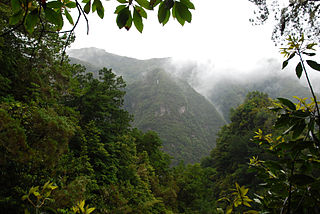
The Annamite Range or the Annamese Mountains is a major mountain range of eastern Indochina, extending approximately 1,100 km (680 mi) through Laos, Vietnam, and a small area in northeast Cambodia. The mountain range is also referred to variously as Annamese Range, Annamese Mountains, Annamese Cordillera, Annamite Mountains and Annamite Cordillera. The name "Annam" is the Vietnamese pronunciation and terminology of Chinese: 安南, meaning "the tranquil south" referring to Vietnam. The French adopted the word and used "Annamese" or "Annamite" to refer to the Vietnamese.

The Lâm Viên Plateau is a plateau in southeastern Vietnam. At its centre is the city of Da Lat. Several mountains in this area rise to over 2,000 m (6,562 ft), the highest being Chư Yang Sin Summit at 2,442 m (8,012 ft).

<span class="mw-page-title-main">Indo-Burma</span> Biodiversity hotspot

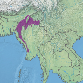
Indo-Burma is a biodiversity hotspot designated by Conservation International.

<span class="mw-page-title-main">Chin Hills–Arakan Yoma montane forests</span> Ecoregion in Myanmar

The Chin Hills-Arakan Yoma montane forests is a tropical and subtropical moist broadleaf forest ecoregion in western Myanmar (Burma). Surrounded at lower elevations by moist tropical forests, this ecoregion is home a diverse range of subtropical and temperate species, including many species characteristic of the Himalayas, as well as many endemic species.

<span class="mw-page-title-main">Black-shanked douc</span> Species of Old World monkey

The black-shanked douc is an endangered species of douc found mostly in the forests of Eastern Cambodia, with some smaller populations in Southern Vietnam. The region they are mostly found in is called the Annamite Range, a mountainous area that passes through Cambodia and Vietnam. Its habitat is mostly characterized by evergreen forest in the mountains, in the middle to upper canopy. They move around quadrupedally and by brachiation up in the trees. This species is unique with its coloration among the doucs as it has a bluish face with yellow rings around its eyes a blue scrotum and a pink penis. Like other doucs, this specie has a tail as long as its body and head length. Black-shanked douc have been observed in groups ranging from 3 to 30 individuals, depending on their habitat. Group tend to have a fission-fusion dynamic that changes with food availability. Their diet varies from dry to wet season. Regardless of the season, their diet consists mostly of leaves, but they have also been found to consume considerable amounts of fruits and flowers during wet season. The species changed conservation status in 2015 from endangered to critically endangered in the IUCN Red List of Endangered Species. This reassessment is due to an increase of the rate of population decline. No global population estimate exists. The majority of the population can be found in Cambodia, with smaller populations in Vietnam. In fact, the Wildlife Conservation Society reports almost 25,000 individuals in Cambodia's Keo Seima Wildlife Sanctuary, a population that has remained stable over the last decade. The largest populations estimated to be in Vietnam is around 500-600 individuals. The biggest challenges that the black-shanked douc faces in terms of conservation are habitat loss and illegal poaching. Conservation efforts are being made to control illegal poaching and trade in Vietnam by putting laws against hunting and trading threatened species.

<span class="mw-page-title-main">Northern Indochina subtropical forests</span> Ecoregion in Southeast Asia

The Northern Indochina subtropical forests are a subtropical moist broadleaf forest ecoregion of northern Indochina, covering portions of Vietnam, Laos, Thailand, Myanmar, and China's Yunnan Province.

<span class="mw-page-title-main">Wildlife of Laos</span>

The wildlife of Laos encompasses the animals and plants found in the Lao People's Democratic Republic, a landlocked country in southeastern Asia. Part of the country is mountainous and much of it is still clad in tropical broadleaf forest. It has a great variety of animal and plant species.

<span class="mw-page-title-main">Bar-throated minla</span> Species of bird

The bar-throated minla or chestnut-tailed minla, or even bar-throated siva, is a species of bird in the laughingthrush and babbler family Leiothrichidae. Traditionally, it has been placed in the genus Minla but is now placed in Actinodura.

<span class="mw-page-title-main">Mizoram–Manipur–Kachin rain forests</span> Ecoregion in Indochina

The Mizoram–Manipur–Kachin rain forests is a subtropical moist broadleaf forest ecoregion which occupies the lower hillsides of the mountainous border region joining Bangladesh, China's Yunnan Province, India, and Myanmar. The ecoregion covers an area of 135,600 square kilometres (52,400 sq mi). Located where the biotas of the Indian Subcontinent and the Indochinese Peninsula meet, and in the transition between subtropical and tropical regions of Asia, the Mizoram–Manipur–Kachin rain forests are home to great biodiversity. The WWF rates the ecoregion as "Globally Outstanding" in biological distinctiveness.

<span class="mw-page-title-main">Phước Bình National Park</span> National park in Vietnam

Phước Bình National Park is a national park in the commune of Phước Bình, Bác Ái District, Ninh Thuận Province. It is located 62 km north-west from Phan Rang town, the capital of Ninh Thuận Province, on the border with Lâm Đồng and Khánh Hòa provinces. Phước Bình National Park was classified as a nature reserve by Decision 125/2002/QD dated 26 September 2002. On 8 June 2006 it was established as a national park under Decision number 822/QĐ-TTg dated 8 June 2006 by then Vice Prime Minister of Vietnam Nguyễn Tấn Dũng.

<span class="mw-page-title-main">Núi Chúa National Park</span> National park in Vietnam

Núi Chúa National Park, formerly Núi Chúa Nature Reserve is a national park in the province of Ninh Thuận Province, on the border with Khánh Hòa Province, South Central Coast, Vietnam.

<span class="mw-page-title-main">Cardamom Mountains rain forests</span> Ecoregion in Thailand and Cambodia

The Cardamom Mountains rain forests is a tropical moist broadleaf forest ecoregion in Southeast Asia, as identified by the WWF. The ecoregion covers the Cardamom Mountains and Elephant Mountains and the adjacent coastal lowlands in eastern Thailand and southwestern Cambodia, as well as the Vietnamese island of Dao Phu Quoc.

<span class="mw-page-title-main">Hainan Island monsoon rain forests</span> Ecoregion in Hainan Island, China

The Hainan Island monsoon rain forests ecoregion covers mountainous interior of Hainan Island in China. The tropical forests receive over 1,000 mm/year of rain, heavily concentrated in the summer rainy season. The island has high levels of biodiversity, with over 4,200 plant species, 630 of which are endemic to the island. The region is under ecological pressure from deforestation for agriculture and timber extraction.

<span class="mw-page-title-main">Luang Prabang montane rain forests</span> Ecoregion in Central Laos and Northeast Thailand

The Luang Prabang montane rain forests ecoregion covers elevations over 800 meters in the Luang Prabang mountains that straddle the border between northern Thailand and north-central Laos, and the highlands that stretch eastward across north-central Laos. While much of the forest cover has been degraded, there are still large areas of relatively untouched forest.

<span class="mw-page-title-main">Northern Annamites rain forests</span> Ecoregion in the Annamites Range

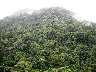
The Northern Annamites rain forests ecoregion covers the rugged and relatively unexplored northern Annamite Mountains of central Laos and Vietnam. There are high numbers of endemic plant species, and the relative remoteness and isolation of the area supports many rare and endangered animals. Rainfall is somewhat less than the lowland rainforest of the lower elevations in Vietnam, and the temperatures slightly cooler due to the higher elevation.

<span class="mw-page-title-main">Northern Vietnam lowland rain forests</span> Ecoregion in Northern Vietnam

The Northern Vietnam lowland rain forests ecoregion covers the central-eastern coast of Vietnam from the Red River delta in the north to Tam Kỳ in the center of the country and neighboring adjacent parts of Laos. The region is one of the wet evergreen forests, with rain over 50 mm in every month. The forests have been highly degraded by human use, and the high levels of biodiversity have been pushed back into relatively small protected areas like Pu Mat National Park.

<span class="mw-page-title-main">Southern Vietnam lowland dry forests</span> Ecoregion (WWF)

The Southern Vietnam lowland dry forests ecoregion covers the low, relatively arid coastal strip of southern Vietnam on the South China Sea. The region is in the rain shadow of the Southern Annamite Range, which blocks humid air from the west. Although approximately half of the ecoregion is forested to some degree, most has at some point been cleared for agriculture or degraded by extraction of hardwoods. There are few protected areas.

<span class="mw-page-title-main">Eastern Java–Bali montane rain forests</span> Ecoregion in Eastern Java and Bali

The Eastern Java–Bali montane rain forests ecoregion covers the higher altitude mountain rainforests on the eastern side of the island of Java, and most of the center of the island of Bali in Indonesia. The region has a number of active volcanoes, but is under pressure from growing human populations pushing into higher elevations and more marginal land. With elevations rising from sea level to 3,426 metres (11,240 ft), and precipitation varying between rainforest and drier forest levels, the area has many different forest types – evergreen, deciduous and semi-alpine.

References

  1. 1 2 3 "Southern Annamites montane rain forests". Digital Observatory for Protected Areas. Retrieved 1 June 2023.
  2. 1 2 3 4 5 6 "Southern Annamites montane rain forests". World Wildlife Federation. Retrieved March 21, 2020.
  3. "Map of Ecoregions 2017". Resolve, using WWF data. Retrieved September 14, 2019.
  4. Kottek, M.; Grieser, J.; Beck, C.; Rudolf, B.; Rubel, F. (2006). "World Map of Koppen-Geiger Climate Classification Updated" (PDF). Gebrüder Borntraeger 2006. Retrieved September 14, 2019.
  5. "Dataset - Koppen climate classifications". World Bank. Retrieved September 14, 2019.
  6. Hara, M., Hoàng, T., Tiến, T., & Ohsawa, M. (2021). Composition and structure of mountain forests containing two tropical pines, Pinus krempfii and Pinus dalatensis, on the Da Lat Plateau, southern Vietnam. Journal of Tropical Ecology, 37(2), 51-63. doi:10.1017/S0266467421000092