Related Research Articles

The flag of Greenland was designed by Greenland native Thue Christiansen. It features two equal horizontal bands of white (top) and red (bottom) with a counter-changed red-and-white disk slightly to the hoist side of centre. The entire flag measures 18 by 12 parts; each stripe measures 6 parts; the disk is 8 parts in diameter, horizontally offset by 7 parts from the hoist to the centre of the circle, and vertically centered.

The krone is the official currency of Denmark, Greenland, and the Faroe Islands, introduced on 1 January 1875. Both the ISO code "DKK" and currency sign "kr." are in common use; the former precedes the value, the latter in some contexts follows it. The currency is sometimes referred to as the Danish crown in English, since krone literally means crown. Krone coins have been minted in Denmark since the 17th century.

The Geological Survey of Denmark and Greenland is the independent sector research institute under the Danish Ministry of Climate and Energy. GEUS is an advisory, research and survey institute in hydrogeology, geophysics, geochemistry, stratigraphy, glaciology, ore geology, marine geology, mineralogy, climatology, environmental history, air photo interpretation, geothermal energy fields concerning Denmark and Greenland.

Ludvig Mylius-Erichsen was a Danish author, ethnologist, and explorer, from Ringkøbing. He was most notably an explorer of Greenland.

The Minister for Foreign Affairs is the head of the Ministry of Foreign Affairs of Denmark. The officeholder is in charge of Danish foreign policy and international relations.

Danmark Fjord, also known as Denmark Sound, is a fjord in northeast Greenland. Administratively it belongs to the Northeast Greenland National Park.

The Wandel Sea is a body of water in the Arctic Ocean, stretching from northeast of Greenland to Svalbard. It is obstructed by ice most of the year.
The Scout and Guide movement in Denmark consists of about ten different associations. Most of them are members of two large federations, but there are also some independent organizations. Affiliated to Danish Scouting and Guiding are the organizations in Greenland, on the Faroe Islands and in Southern Schleswig.

The Danish Realm, officially the Kingdom of Denmark, or simply Denmark, is a country and refers to the area over which the monarch of Denmark is head of state. It consists of metropolitan Denmark—the kingdom's territory in continental Europe and sometimes called "Denmark proper" —and the realm's two autonomous regions: the Faroe Islands in the North Atlantic and Greenland in North America. The relationship between the three parts of the Kingdom is also known as The unity of the Realm.

Germania Land or Germanialand is a peninsula in northeastern Greenland. Despite the high latitude it is largely unglaciated.

The following is an alphabetical list of topics related to the nation of Kalaallit Nunaat (Greenland).
Upernavik Archipelago is a vast coastal archipelago in the Avannaata municipality in northwestern Greenland, off the shores of northeastern Baffin Bay. The archipelago extends from the northwestern coast of Sigguup Nunaa peninsula in the south at approximately 71°50′N56°00′W to the southern end of Melville Bay in the north at approximately 74°50′N57°30′W.
Godfred Hansen Island is an uninhabited island of the Greenland Sea, Greenland.

King Frederik VIII Land is a major geographic division of northeastern Greenland. It extends above the Arctic Circle from 76°N to 81°N in a North-South direction along the coast of the Greenland Sea.
Petermann Peak,, also known as Petermann Fjeld, Petermanns Topp and Petermann Point is a mountain in King Christian X Land, Northeast Greenland. Administratively it is part of the Northeast Greenland National Park zone.

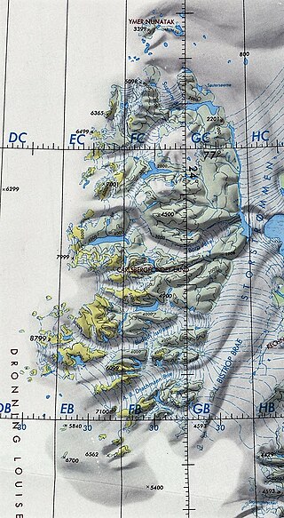
Queen Louise Land is a vast mountainous region located west of Dove Bay, King Frederik VIII Land, northeastern Greenland. Administratively it is part of the Northeast Greenland National Park zone.

The Denmark expedition, also known as the Denmark Expedition to Greenland's Northeast Coast and the Danmark Expedition after the ship's name, was an expedition to northeastern Greenland in 1906–1908.

The bark Danmark is best known for her role as expedition ship for the Danmark expedition (1906–08), so named after the ship, but had a long prehistory as a whaler under the name Sir Colin Campbell of Peterhead and later as a sealer named Magdalena of Tønsberg/Kristiana.

The Roosevelt Range or Roosevelt Mountains is a mountain range in Northern Greenland. Administratively this range is part of the Northeast Greenland National Park. Its highest peak is the highest point in Peary Land.

The Daly Range or Daly Mountains is a mountain range in Peary Land, Northern Greenland. Administratively this range is part of the Northeast Greenland National Park.