List of mountains in Ukraine

Last updated

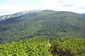
There are two predominant mountain regions in Ukraine: the Carpathians and the Crimean Mountains. Ukraine is located at East European Plain, therefore most of its area consists mostly of rolling hills rather than real mountains. Some high peaks could be found in areas of Podilian Tovtry and Donets Ridge and rarely elsewhere.
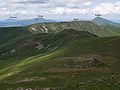
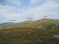
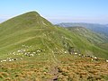
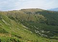
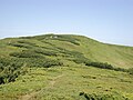
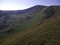
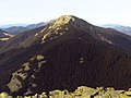
Chornohora (lit.'Black Mountain') is a mountain range in the Carpathians which consists of the highest mountain peaks in the country. Other notable ranges are Maramureş and Gorgany, also located in the Carpathians. In the Crimean Mountains, the highest mountain range, Babuğan yayla  [ uk ], is located closer to the Crimean Southern Coast and is part of the main mountain chain.

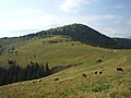
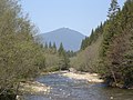
This page shows the highest mountains in Ukraine.

Highest mountains in Ukraine

This list contains peaks with height above 1,500 m. The numbering (except of first 10) is disputable.

RankImageMountainHeight (m)SystemRangeCoordinates
1 Goverla Lazeshchini.jpg Hoverla 2,061 Carpathian Chornohora 48°09′36″N24°30′01″E / 48.16000°N 24.50028°E / 48.16000; 24.50028
2 Gora Brebeneskul.JPG Brebeneskul 2,035 Carpathian Chornohora 48°05′54″N24°34′50″E / 48.09833°N 24.58056°E / 48.09833; 24.58056
3 Pop Iwan.jpg Pip Ivan 2,021 Carpathian Chornohora 48°02′52″N24°37′40″E / 48.04778°N 24.62778°E / 48.04778; 24.62778
4 Petros 2.jpg Petros 2,020 Carpathian Chornohora 48°10′22″N24°25′16″E / 48.17278°N 24.42111°E / 48.17278; 24.42111
5 Gutin Tomnatyk.jpg Hutyn Tomnatyk 2,016 Carpathian Chornohora 48°06′00″N24°33′24″E / 48.10000°N 24.55667°E / 48.10000; 24.55667
6 Rebra ukr.jpg Rebra 2,001 Carpathian Chornohora 48°06′41″N24°33′36″E / 48.11139°N 24.56000°E / 48.11139; 24.56000
7 Hutyn Tomnatyk, Brebeneskul, Menchul.jpg Menchul 1,998 Carpathian Chornohora 48°05′30″N24°35′45″E / 48.09167°N 24.59583°E / 48.09167; 24.59583
8 Pip Ivan Marmaroski view.jpg Pip Ivan 1,936 Carpathian Maramureș 48°55′35″N24°19′30″E / 48.92639°N 24.32500°E / 48.92639; 24.32500
9 Howerla.jpg Turkul 1,933 Carpathian Chornohora 48°07′26″N24°31′52″E / 48.12389°N 24.53111°E / 48.12389; 24.53111
10 Breskul.jpg Breskul 1,911 Carpathian Chornohora 48°09′04″N24°30′43″E / 48.15111°N 24.51194°E / 48.15111; 24.51194
11 Smotrych (hora)-2.JPG Smotrych 1,898 Carpathian Chornohora 48°04′10″N24°38′43″E / 48.06944°N 24.64528°E / 48.06944; 24.64528
12 Svydovec, Blyznycja, jih.jpg Blyznytsya 1,882 Carpathian Svydovets 48°13′21″N24°13′58″E / 48.22250°N 24.23278°E / 48.22250; 24.23278
13 DzembroniaHora.jpg Dzembronia 1,877 Carpathian Chornohora 48°04′38″N24°36′18″E / 48.07722°N 24.60500°E / 48.07722; 24.60500
14 Shpyci-1.jpg Shpytsi 1,863 Carpathian Chornohora 48°07′32″N24°34′05″E / 48.12556°N 24.56806°E / 48.12556; 24.56806
15 Petrosul 1,855 Carpathian Chornohora 48°04′38″N24°36′18″E / 48.07722°N 24.60500°E / 48.07722; 24.60500
16 Dancerz Pozyzewska Howerla pol.jpg Dantsir 1,856 Carpathian Chornohora 48°08′06″N24°31′52″E / 48.13500°N 24.53111°E / 48.13500; 24.53111
17 Pozhyzhevska 1,822 Carpathian Chornohora 48°8′38″N24°31′27″E / 48.14389°N 24.52417°E / 48.14389; 24.52417
18 Neniska Velyka 1,820 Carpathian Maramureș
19 Syvulia 02.jpg Syvulya 1,818 Carpathian Gorgany
20 Igrovets'.JPG Ihrovets 1,803 Carpathian Gorgany
21 Zherban 1,795 Carpathian Maramureș
22 Bratkivs'ka.JPG Bratkivska 1,788 Carpathian Gorgany
23 Vidrig "Velikii Kozel" i gora Gomul.JPG Homul 1,788 Carpathian Chornohora
24 Petros Marmorosky.JPG Petros 1,784 Carpathian Maramureș
25 Shuryn-1.jpg Shuryn 1,772 Carpathian Chornohora
26 Velyky Kotel 1,771 Carpathian Svydovets
27 Chyvchyn osinniy.jpg Chyvchyn 1,769 Carpathian Chyvchyn
28 Dohyaska 1,764 Carpathian Svydovets
29 Gropa1.JPG Hropa 1,763 Carpathian Gorgany
30 Svydovec, Drahobrat, Gorgany.jpg Dragobrat 1,763 Carpathian Svydovets
30 Gory 408.jpg Dovbushanka 1,754 Carpathian Gorgany
31 Grofa 01.jpg Grofa 1,748 Carpathian Gorgany
32 Popadia 01.jpg Popadya 1,740 Carpathian Gorgany
33 Parenki 01.jpg Parenky 1,735 Carpathian Gorgany
34 Koman 1,723 Carpathian Chyvchyn
35 M Moloda RB.jpg Moloda 1,723 Carpathian Gorgany
36 Strymba.JPG Strymba 1,719 Carpathian Gorgany
37 Chorna Klyva.JPG Chorna Kleva 1,719 Carpathian Gorgany
38 Tataruka-1.jpg Tataruka 1,711 Carpathian Svydovets
39 Durnia.JPG Durna 1,709 Carpathian Gorgany
40 Unhariaska-2.jpg Unharyaska 1,708 Carpathian Svydovets
41 Nehrovets 1,707 Carpathian Gorgany
42 Svidovec2.JPG Stih 1,707 Carpathian Svydovets
43 Bushtul 1,691 Carpathian Gorgany
44 Yaiko-Ilemske RB.jpg Yayko-Ilemske 1,679 Carpathian Gorgany
45 Budychevska Velyka 1,677 Carpathian Chyvchyn
46 Stiy mountain.JPG Stiy 1,677 Carpathian Borzhava
47 Bert 1,666 Carpathian Gorgany
48 Synyak.JPG Synyak 1,665 Carpathian Gorgany
49 Stig (marmarosh).jpg Stih 1,635 Carpathian Maramureș
50 Tempa 1,635 Carpathian Svydovets
51 Pidpula 1,634 Carpathian Svydovets
52 Vid na goru Iaiko Ilems'ke z mosta cherez r. Moloda (ur. Trikutnik).JPG Yayko-Perehinske 1,595 Carpathian Gorgany
53 Baba-Lyudova 1,590 Carpathian Hrynyavy
54 Kernychny 1,588 Carpathian Chyvchyn
55 Arshytsia RB.jpg Gorgan-Ilemsky 1,587 Carpathian Gorgany
56 Skupova 1,583 Carpathian Hrynyavy
57 Yarovytsya 1,574 Carpathian Yalovychory
58 Berlyaska 1,555 Carpathian Svydovets
59 Tarnavytsya 1,553 Carpathian Hrynyavy
60 Roman-Kosh (Crimea) top2.jpg Roman-Kosh 1,545 Crimean Babuğan Yayla 44°36′39″N34°14′36″E / 44.61083°N 34.24333°E / 44.61083; 34.24333
61 Demir-Kapu.jpg Demir-Kapu 1,540 Crimean Nikit Yayla 44°35′06″N34°12′26″E / 44.58500°N 34.20722°E / 44.58500; 34.20722
62 Zeytin-Kosh 1,537 Crimean Babuğan Yayla 44°37′02″N34°16′49″E / 44.61722°N 34.28028°E / 44.61722; 34.28028
63 Roman-Kosh (Crimea) top2.jpg Kemal-Egerek 1,529 Crimean Nikit Yayla 44°34′44″N34°11′04″E / 44.57889°N 34.18444°E / 44.57889; 34.18444
64 Eklizi-Burun-mountain.jpg Eklizi-Burun 1,527 Crimean Çatır Dağ 44°44′24″N34°17′19″E / 44.74000°N 34.28861°E / 44.74000; 34.28861
65 Roztitska 1,527 Carpathian Hrynyavy
66 Magura-Zhyde.jpg Zhyd-Mahura 1,518 Carpathian Borzhava
67 Ukraine-Velykyy Verkh Mountain-1.jpg Velyky Verkh 1,508 Carpathian Borzhava
68 Pikui. Naivishcha vershina L'vivs'koyi oblasti..jpg Pikui 1,405 Carpathian Striysko-Syanskaya Verkhovina 48°49′48″N23°00′02″E / 48.83000°N 23.00056°E / 48.83000; 23.00056
69 Parashka.JPG Parashka 1,268.5 Carpathian Parashka range 49°04′10″N23°24′51″E / 49.06944°N 23.41417°E / 49.06944; 23.41417
70 Mt. Trostyan (1235 m)..JPG Trostian 1,235 Carpathian Striysko-Syanskaya Verkhovina 48°51′24″N23°23′31″E / 48.85667°N 23.39194°E / 48.85667; 23.39194

[A link was removed because it sent the user to an unrelated website ]

Related Research Articles

<span class="mw-page-title-main">Geography of Romania</span> Overview of the geography of Romania

With an area of 238,397 km2 (92,046 sq mi), Romania is the twelfth-largest country in Europe. It is a Balkan country located at the crossroads of Eastern and Southeast Europe. It's bordered on the Black Sea, the country is halfway between the equator and the North Pole and equidistant from the westernmost part of Europe—the Atlantic Coast—and the most easterly—the Ural Mountains. Romania has 3,195 kilometres (1,985 mi) of border. Republic of Moldova and Ukraine lies to the east, Bulgaria lies to the south, and Serbia and Hungary to the west. In the southeast, 245 kilometres (152 mi) of sea coastline provide an important outlet to the Black Sea and the Atlantic Ocean.

<span class="mw-page-title-main">Geography of Ukraine</span> Geography of the country of Ukraine

Ukraine is the second-largest European country, after Russia. Its various regions have diverse geographic features ranging from highlands to lowlands, as well as climatic range and a wide variety in hydrography. Most of the country lies within the East European Plain.

<span class="mw-page-title-main">Carpathian Mountains</span> Mountain range in Central and Eastern Europe

The Carpathian Mountains or Carpathians are a range of mountains forming an arc across Central Europe. Roughly 1,500 km (930 mi) long, it is the third-longest European mountain range after the Urals at 2,500 km (1,600 mi) and the Scandinavian Mountains at 1,700 km (1,100 mi). The range stretches from the far eastern Czech Republic (3%) and Austria (1%) in the northwest through Slovakia (21%), Poland (10%), Ukraine (10%), Romania (50%) to Serbia (5%) in the south. The highest range within the Carpathians is known as the Tatra mountains in Poland and Slovakia, where the highest peaks exceed 2,600 m (8,500 ft). The second-highest range is the Southern Carpathians in Romania, where the highest peaks range between 2,500 m (8,200 ft) and 2,550 m (8,370 ft).

<span class="mw-page-title-main">East European Plain</span> Vast interior plain east of the North/Central European

The East European Plain is a vast interior plain extending east of the North European Plain, and comprising several plateaus stretching roughly from 25 degrees longitude eastward. It includes Volhynian-Podolian Upland on its westernmost fringe, the Central Russian Upland, and, on the eastern border, encompasses the Volga Upland. The plain includes also a series of major river basins such as the Dnepr Basin, the Oka–Don Lowland, and the Volga Basin. At the southeastern point of the East European Plain are the Caucasus and Crimean mountain ranges. Together with the North European Plain, and covering the Baltic states, European Russia, Belarus, Ukraine, Moldova, southeastern Romania, and, at its southernmost point, the Danubian Plain in Northern Bulgaria, it constitutes the majority of the Great European Plain, the greatest mountain-free part of the European landscape. The plain spans approximately 4,000,000 km2 (2,000,000 sq mi) and averages about 170 m (560 ft) in elevation. The highest point of the plain, located in the Valdai Hills, is 346.9 metres (1,138.1 ft).

<span class="mw-page-title-main">Bieszczady Mountains</span> Mountain range in Poland, Slovakia, and Ukraine

Bieszczady Mountains is a mountain range that runs from the extreme south-east of Poland and north-east of Slovakia through to western Ukraine. It forms the western part of the Eastern Beskids, and is more generally part of the Outer Eastern Carpathians. The mountain range is situated between the Łupków Pass and the Vyshkovskyi Pass. The highest peak of Bieszczady is Mt Pikui in Ukraine. The highest peak of the Polish part is Tarnica.

<span class="mw-page-title-main">Chornohora</span> Mountain range in Ukraine

Chornohora is the highest mountain range in Western Ukraine. It is within the Polonynian Beskids, a subgroup of the mountain group of Eastern Beskids, which in turn is part of the Outer Eastern Carpathians.

<span class="mw-page-title-main">Gorgany</span> Mountain range in Western Ukraine

Gorgany is a mountain range in Western Ukraine in Outer Eastern Carpathians, adjacent to Chornohora range. The highest peak of Gorgany is Syvulia with the other high peaks including Ihrovyshche, Vysoka, Lopushna and Grofa. The mountains are made of flysch rock, mostly sandstone, which create typical for Gorgany debris fields. They are bordered by the Mizunka River and Vyshkiv Pass in the west and the Prut River and Yablunytsia Pass in the east.

<span class="mw-page-title-main">Crimean Mountains</span> Mountain range along the southeastern coast of Crimea

The Crimean Mountains or Yayla Mountains are a range of mountains running parallel to the south-eastern coast of Crimea, between about 8–13 kilometers from the sea. Toward the west, the mountains drop steeply to the Black Sea, and to the east, they change slowly into a steppe landscape.

<span class="mw-page-title-main">North Hungarian Mountains</span> Mountain range in Hungary and Slovakia

The North Hungarian Mountains, sometimes also referred to as the Northeast Hungarian Mountains, Northeast Mountains, North Hungarian Highlands, North Hungarian Mid-Mountains or North Hungarian Range, is the northern, mountainous part of Hungary. It forms a geographical unity with the Mátra-Slanec Area, the adjacent parts of Slovakia. It is a separate geomorphological area within the Western Carpathians.

<span class="mw-page-title-main">Gutin Mountains</span>

The Gutin Mountains are a mountain range within the Vihorlat-Gutin Area of the Inner Eastern Carpathians. They are centered in Maramureș County in Romania, bordering Satu Mare County, and also stretching further towards northwest as the Oaș Mountains, and reaching the border with Zakarpattia Oblast in Ukraine.

<span class="mw-page-title-main">Bukovinian Subcarpathians</span>

Bukovinian Subcarpathians is a geographic area in the NNE of Romania and SWW of Ukraine, situated to the east and north-east of the Eastern Carpathian Mountains. It is a subunit of the Eastern Carpathian Foothills.

<span class="mw-page-title-main">OaČ™ Mountains</span>

The Oaș Mountains are a small volcanic mountain range within the Vihorlat-Gutin Area of the Inner Eastern Carpathians. The mountains are centered in northern section of the Țara Oașului, covering border area between the Satu Mare County in Romania, and the Zakarpattia Oblast in Ukraine. They are an extension of the Gutin Mountains.

<span class="mw-page-title-main">Svydovets</span> Mountain range in Ukraine

The Svydovets is a mountain range in western Ukraine, one of the ranges of Eastern Beskids, itself belonging to the Outer Eastern Carpathians. It is a biodiversity hotspot in the Ukrainian Carpathians. The territories of the Svydovets mountain range belong to the state. The highest peak of the range is Blysnyzi mountain. The Black Tisza, the source of Tisza, is one of the more fullflowing rivers of the region, it flows out from the Svydovets.

<span class="mw-page-title-main">Skole Beskids</span> Mountain range in Ukraine

The Skole Beskids is a mountain range in western Ukraine, belonging to the set of ranges called the Eastern Beskids, within the Outer Eastern Carpathians.

<span class="mw-page-title-main">Carpathian Biosphere Reserve</span> UNESCO biosphere reserve in Ukrainian Carpathian mountains

Carpathian Biosphere Reserve is a biosphere reserve in Ukraine that was established in 1968 and became part of the World Network of Biosphere Reserves of UNESCO in 1992. Since 2007 bigger portion of the reserve along with some territories of the Uzh River National Park was listed with the UNESCO World Heritage Sites as part of the Ancient and Primeval Beech Forests of the Carpathians and Other Regions of Europe.

<span class="mw-page-title-main">Wildlife of Ukraine</span>

The wildlife of Ukraine consists of its diverse fauna, flora and funga. The reported fauna consists of 45,000 species when including the areas of the Black Sea and the Sea of Azov. Ukraine's protected environments consist of 33 Ramsar sites covering an area of 7,446.51 square kilometres (2,875.11 sq mi). Biosphere nature reserves and three national parks are all part of the GEF projects portfolio of conservation of biodiversity in the Danube Delta. Their vegetation pattern is mixed forest area, forest-steppe area, steppe area, Ukrainian Carpathian Mountains and Crimean Mountains. Some of the protected areas that were reserves or parks are subsumed under the biosphere reserves.

<span class="mw-page-title-main">Sanok-Turka Mountains</span>

The Sanok-Turka Mountains are a mountain range in the Eastern Beskids, within the Outer Eastern Carpathians. They are located in southern border section between Poland and Ukraine.

<span class="mw-page-title-main">Dragobrat (Mountain)</span>

Dragobrat is a mountain of the Urdu-Flavantuch mountain range in the eastern part of the Svydovets massif. It is located in the Rakhiv district of the Zakarpattia region, between the rivers Chorna Tysa and Kosivska.