List of mountains in Slovakia

Last updated
Map of Slovakia. Slovakia-geographic map-en.svg
Map of Slovakia.

This is a listof mountains in Slovakia, that contains all mountains in the Slovak Republic sorted by alphabetical order.

Contents

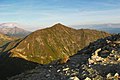
The most predominant mountain regions in Slovakia are the Carpathians. Slovakia is a landlocked Central European country, with more mountainous regions in the north and flat terrain in the south. [1]

Highest peaks

Geomorphological divisions of Slovakia. Geomorphologische Einteilung der Slowakei.png
Geomorphological divisions of Slovakia.
The Gerlachovsky stit. Gerlachovsky stit Vysoke Tatry 03.jpg
The Gerlachovský štít.

Around 8,489 named mountains shape the landscape of Slovakia, which covers an area of 49,035 square kilometers (18,933 square miles), with peaks distributed throughout nearly the entire country, excluding the southwestern corner. Gerlachovský štít stands as Slovakia's highest and most distinguished mountain, reaching an elevation of 2,655 meters (8,711 feet) and a prominence of 2,356 meters (7,730 feet), ranking it among the ten tallest mountains in the Carpathian range. [2]

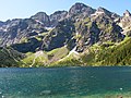
The Tatra Mountains, with 29 peaks higher than 2,500 metres (8,202 feet) AMSL, are the highest mountain range in the Carpathian Mountains. The Tatras occupy an area of 750 square kilometres (290 sq mi), of which the greater part 600 square kilometres (232 sq mi) lies in Slovakia. They are divided into several parts. [3]

List of mountains

NameImageHeight (m)Height (ft)LocationRangeNote
Albínovská hora Albinov Hill east view.PNG 177581 Sečovce Eastern Slovak Hills  
Babia Góra 8maja2006 babiagora 035.jpg 1,7255,659 Polish/Slovak border Żywiec Beskids  
Baníkov Banikov.jpg 2,1787,146 Žilina Region Western Tatras  
Black Mountain Mountains Cierna hora Slovakia 675.jpg 1,0293,376 Košice Region Slovak Ore Mountains
Borišov Borisov, Velka Fatra (SVK) - view from Krackov.jpg 1,5094,952 Martin Veľká Fatra
Bystrá Bystra from Klin.jpg 2,2487,375 Žilina Region Western Tatras Is the highest mountain in the Western Tatras. [4]
Chopok Chopok top.jpg 2,0246,640 Žilina Region Low Tatra Is the third highest peak of the Low Tatra range. [5]
Ciemniak Ciemniak a9.jpg 2,0966,877 Polish/Slovak border Tatra Mountains and Carpathian Mountains Slovak sources list its elevation as 2,090 m. [6]
Cubryna Morskie Oko - panoramio - Slawomir Hutryk.jpg 2,3767,975 Polish/Slovak border High Tatras and Tatra Mountains One of the highest peaks in Poland. [7]
Czerwone Wierchy Czerwone Wierchy, widok z Giewontu.jpg 2,1226,962 Polish/Slovak border Western Tatras and Tatra Mountains
Dereše Derese2.jpg 2,0046,575 Žilina Region Low Tatras Is the third highest peak of the Low Tatra range. [8]
Devínska Kobyla Devinska Kobyla 02.jpg 5141,686 Bratislava Little Carpathians Is the highest point of Bratislava. [9]
Drieňok Drienok.jpg 1,2684,160 Turčianske Teplice Veľká Fatra
Gerlachovský štít Gerlachovsky stit z Granatovej lavky.jpg 2,6548,709 Prešov Region High Tatras Tallest mountain in Slovakia. [10]
Stratenec Stratenec Mala Fatra.JPG 1,5094,951 Žilina Region Malá Fatra  

References

  1. Vaškovský, Imrich; Vaškovská, Eugenia (1981). "The development of the natural landscape in Slovakia during the Quaternary". Biuletyn Peryglacjalny . 28: 249–258.
  2. "Gerlachovský štít - Peakbagger.com". www.peakbagger.com. Retrieved 2025-12-26.
  3. Krupa, Maciej (2004). The Tatra Mountains. Parma Press. ISBN   978-83-7419-011-4.
  4. "Why You Need to Go Hiking in Slovakia's Tatra Mountains". Much Better Adventures Magazine. 2019-07-11. Archived from the original on 2025-06-22. Retrieved 2025-12-27.
  5. "Hiking". Zruby pod Chopkom. Retrieved 2025-12-27.
  6. Cywiński, Władysław (1996). Czerwone Wierchy, część zachodnia[Red Peaks, Western Part] (in Polish). Vol. 3. Poronin: Wyd. Górskie. ISBN   83-7104-011-3.
  7. "Hiking". Zruby pod Chopkom. Retrieved 2025-12-27.
  8. "Dereše". derese.slovakian-mountains.eu. Retrieved 2025-12-27.
  9. "Protected Wildlife by the Morava | Green Bratislava". Visit Bratislava. Retrieved 2025-12-27.
  10. "Gerlachovský štít peak (High Tatras) - Slovakia.travel". slovakia.travel. Archived from the original on 2025-05-13. Retrieved 2025-12-26.