
The Tatra Mountains, Tatras, or Tatra, are a series of mountains within the Western Carpathians that form a natural border between Slovakia and Poland. They are the highest mountains in the Carpathians. The Tatras are distinct from the Low Tatras, a separate Slovak mountain range further south.

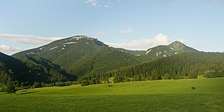
The Low Tatras or Low Tatra is a mountain range of the Inner Western Carpathians in central Slovakia.

Castle Mountain is a mountain located within Banff National Park in the Canadian Rockies, approximately halfway between Banff and Lake Louise. It is the easternmost mountain of the Main Ranges in the Bow Valley and sits astride the Castle Mountain Fault which has thrust older sedimentary and metamorphic rocks forming the upper part of the mountain over the younger rocks forming its base. The mountain's castellated, or castle-like, appearance is a result of erosive processes acting at different rates on the peak's alternating layers of softer shale and harder limestone, dolomite and quartzite.

Kriváň is a mountain in the High Tatras, Slovakia, that dominates the upper part of the former Liptov County. Multiple surveys among nature lovers have ranked it as the country's most beautiful peak. Readily accessible along maintained marked trails and with the exceptional vistas afforded from its summit, it is the hikers' favorite mountain in the western part of the High Tatras. Kriváň has also been a major symbol in Slovak ethnic and national activism for the past two centuries. It has been referenced in works of art from 19th-century literature, through paintings, film documentaries, to a Polish rock track. A country-wide vote in 2005 selected it to be one of the images on Slovakia's euro coins.

Veľká Fatra is a mountain range in the Western Carpathians in Slovakia. The Veľká Fatra lie to the southeast of the better known Malá (Lesser) Fatra mountains and are less developed, as well as being lower.

The Malá Fatra National Park is a national park in the northern part of the Malá Fatra mountains called Krivánska Malá Fatra.

Malá Fatra is a mountain range in the Western Carpathians in the north-west of Central Slovakia. In the geomorphological system, it is a part of the Fatra-Tatra Area.

The Little Carpathians are a low mountain range, about 100 km long, and part of the Carpathian Mountains. The mountains are situated in Western Slovakia, covering the area from Bratislava to Nové Mesto nad Váhom, and northeastern Austria, where a very small part called Hundsheimer Berge is located south of the Devín Gate. The Little Carpathians are bordered by the Záhorie Lowland in the west and the Danubian Lowland in the east.

Monte Binga is the highest mountain in Mozambique and the second-highest mountain in Zimbabwe. It is located in the Chimanimani Mountains, on the border between Zimbabwe and Mozambique in the Chimanimani Transfrontier Park in Manica Province. Its height is 8004 feet (2440m) above sea level.

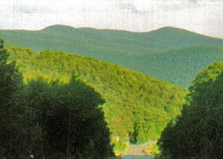
Rusk Mountain is a peak located in the towns of Jewett and Lexington in Greene County, New York, United States. At 3,680 feet (1,120 m) in elevation, it is the 20th-highest peak in the Catskill Mountains and considered a member of the Catskill High Peaks. While there is no maintained trail, a bushwhack to the summit is considered relatively easy, and required for membership in the Catskill Mountain 3500 Club.
Panther Mountain is one of the Catskill High Peaks, located in the Town of Shandaken in Ulster County, New York. At approximately 3,720 feet (1,130 m) in elevation, it is the 18th highest in the range. A combination of factors has led some geologists to believe the mountain is on the site of an ancient meteorite impact crater.

Veľká Fatra National Park is a National Park in Slovakia. Most of it lies in the southern part of the Žilina Region and a small part in the northern part of Banská Bystrica Region. The national park and its protective zone comprise most of the Greater Fatra Range which belongs to the Outer Western Carpathians.
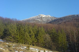
Tlstá is a mountain in the Bralná Fatra part of the Greater Fatra Range, measuring 1,373.3 m (4,506 ft). It is located over the Turiec Valley, rising steeply nearly 1,000 m (3,300 ft) above the valley bottom. It has rugged slopes with many rock spires and rock terraces under the grass-covered summit. With its well-preserved forests, rare plants and many karst caves in the massif, the mountain and its surrounding area were declared a National Nature Reserve in 1981, covering an area of 30.66 km2 (11.84 sq mi). Together with the opposite Ostrá Mountain and Gader Valley beneath them, they create one of the most valuable and picturesque parts of the Greater Fatra Range.
The Strážov Mountains are a mountain range in northwestern Slovakia, being part of Inner Western Carpathians, and of the Fatra-Tatra Area. They are situated between the towns of Trenčín, Považská Bystrica, Rajec, Prievidza and Bánovce nad Bebravou, bordering White Carpathians and the Váh river in the northwest and west, Javorníky in the north, Malá Fatra in the east, Vtáčnik and Nitra river in the south and Považský Inovec in the southwest. The highest mountain is Strážov

Muránska planina National Park is one of the youngest national parks in Slovakia. The core area measures 21,318 ha and the protective belt 21,698 ha. It includes 14 smaller protected territories. The headquarters are located in Revúca.

Vrátna dolina or Vrátna Valley is a valley in the Malá Fatra mountain range in Slovakia. It is situated 3 kilometers from the village of Terchová in the Žilina Region. Vrátna dolina covers an area of approximately 36 km2 (13,9 mi2). There are four access points into the valley: Tiesňavy, Stará dolina, Nová dolina, and Starý dvor.

The Fatra-Tatra Area or the Tatra-Fatra Belt of core mountains is a part of the Inner Western Carpathians, a subprovince of the Western Carpathians. Most of the area lies in Slovakia with small parts reaching into Austria and Poland. The highest summit of the whole Carpathians, the Gerlachovský štít at 2,655 m (8,711 ft), lies in the High Tatras range which belongs to this area.

This article gives an overview of the geomorphological division of Slovakia. It is ordered in a hierarchical form, belonging to the Alps-Himalaya System and to the sub-systems of the Carpathian Mountains and of the Pannonian Basin. These subsystems are subsequently divided into provinces, sub-provinces and areas.

Balsam Mountain is one of the High Peaks of the Catskill Mountains in the U.S. state of New York. Its exact height has not been determined, so the highest contour line, 3,600 feet (1,100 m), is usually given as its elevation. It is located in western Ulster County, on the divide between the Hudson and Delaware watersheds. The summit and western slopes of the peak are within the Town of Hardenburgh and its eastern slopes are in Shandaken. The small community of Oliverea is near its base on that side. Most of the mountain is publicly owned, managed by the New York State Department of Environmental Conservation as part of the state Forest Preserve, part of the Big Indian-Beaverkill Range Wilderness Area in the Catskill Park. The summit is on a small corner of private land.
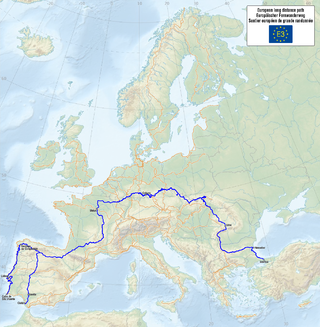
The E3 European long distance path, or just E3 path, is a 6,950-kilometre (4,320 mi) long-distance footpath that is planned to run from the Portuguese coast to the Black Sea in Bulgaria. It is one of the network of European long-distance paths.


