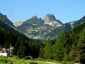
Mountains constitute a significant part of Bulgaria and are dominant in the southwest and central parts. Bulgaria's highest mountains are Rila (highest peak Musala, 2925 m; the highest in the Balkans) and Pirin (highest peak Vihren, 2914 m). The large mountain chain of Stara planina (Balkan Mountains) runs west–east across the entire country, bisecting it and giving the name to the entire Balkan peninsula. Other extensive mountains are the massifs Rhodopes and Strandzha in the south.
|
|
Bulgaria is a country situated in Southeast Europe that occupies the eastern quarter of the Balkan peninsula, being the largest country within its geographic boundaries. It borders Romania to the north, Serbia and North Macedonia to the west, Greece and Turkey to the south, and the Black Sea to the east. The northern border with Romania follows the river Danube until the city of Silistra. The land area of Bulgaria is 110,994 square kilometres (42,855 sq mi), slightly larger than that of Cuba, Iceland or the U.S. state of Tennessee. Considering its relatively compact territorial size and shape, Bulgaria has a great variety of topographical features. Even within small parts of the country, the land may be divided into plains, plateaus, hills, mountains, basins, gorges, and deep river valleys. The geographic center of Bulgaria is located in Uzana.
The Rhodopes are a mountain range in Southeastern Europe, and the largest by area in Bulgaria, with over 83% of its area in the southern part of the country and the remainder in Greece. Golyam Perelik is its highest peak at 2,191 meters (7,188 ft). The mountain range gives its name to the terrestrial ecoregion Rodope montane mixed forests that belongs in the temperate broadleaf and mixed forests biome and the Palearctic realm. The region is particularly notable for its karst areas with their deep river gorges, large caves and specific sculptured forms, such as the Trigrad Gorge.
Blagoevgrad Province, also known as Pirin Macedonia or Bulgarian Macedonia, is a province (oblast) of southwestern Bulgaria. It borders four other Bulgarian provinces to the north and east, the Greek region of Macedonia to the south, and North Macedonia to the west. The province has 14 municipalities with 12 towns. Its principal city is Blagoevgrad, while other significant towns include Bansko, Gotse Delchev, Melnik, Petrich, Razlog, Sandanski, and Simitli.
Musala ; from Arabic through Ottoman Turkish: from Musalla, "near God" or "place for prayer" is the highest peak in the Rila Mountains, as well as in Bulgaria and the entire Balkan Peninsula, standing at 2,925.42 metres (9,597.8 ft).
Vitosha, the ancient Scomius or Scombrus, is a mountain massif, on the outskirts of Sofia, the capital of Bulgaria. Vitosha is one of the symbols of Sofia and the closest site for hiking, alpinism and skiing. Convenient bus lines and rope ways render the mountain easily accessible. Vitosha has the outlines of an enormous dome. The territory of the mountain includes Vitosha nature park that encompasses the best known and most frequently visited parts. The foothills of Vitosha shelter resort quarters of Sofia; Knyazhevo quarter has mineral springs. Vitosha is the oldest nature park in the Balkans. The mountain emerged as a result of volcanic activity and has been subsequently shaped by the slow folding of the granite rock layers and a series of gradual uplifts of the area. It appears dome shaped at first sight, but the mountain, 19 km long by 17 km wide, actually consists of concentric denudational plateaus rising in tiers one above the other. Vitosha is separated into four main parts whose main ridges gather at a crown known as Cherni Vrah. This is the highest point of the mountain at 2290 m and is one of 12 peaks of Vitosha over 2000 m in height. It is the highest massif of Srednogorie mountain chain system, together with Sredna gora, Plana (mountain), Lyulin Mountain, Greben (mountain), Viskyar Mountain, etc. They all are a result of the folding of the earth layers through the Mesozoic, causing also magma sheet-like intrusion that has been injected between layers of sedimentary rock. The laccolithic domed form of Vitosha is a typical example.
Rila is the highest mountain range of Bulgaria, the Balkan Peninsula and Southeast Europe. It is situated in southwestern Bulgaria and forms part of the Rila–Rhodope Massif. The highest summit is Musala at an elevation of 2,925 m which makes Rila the sixth highest mountain range in Europe after the Caucasus, the Alps, Sierra Nevada, the Pyrenees and Mount Etna, and the highest one between the Alps and the Caucasus. It spans a territory of 2,629 km2 with an average elevation of 1487 m. The mountain is believed to have been named after the river of the same name, which comes from the Old Bulgarian verb "рыти" meaning "to grub".
The Pirin Mountains are a mountain range in southwestern Bulgaria, with the highest peak, Vihren, at an altitude of 2,914 m (9,560 ft).
Pirin National Park, originally named Vihren National Park, encompasses the larger part of the Pirin Mountains in southwestern Bulgaria, spanning an area of 403.56 square kilometers (155.82 sq mi).
Sredna Gora is a mountain range in central Bulgaria, situated south of and parallel to the Balkan Mountains and extending from the Iskar to the west and the elbow of Tundzha north of Yambol to the east. Sredna Gora is 285 km long, reaching 50 km at its greatest width. Its highest peak is Golyam Bogdan at 1,604 m (5,262 ft).
Vihren is the highest peak of Bulgaria's Pirin Mountains. Reaching 2,914 metres (9,560 ft), it is Bulgaria's second and the Balkans' third highest, after Musala and Mount Olympus. Although due to the karst topography Vihren is deprived of lakes and streams, a number of Pirin's lakes are located around the peak, as is Europe's southernmost glacial mass, the Snezhnika glacieret. Until 1942 Vihren was known as Eltepe ; it was also called Buren (stormy) and Malnienosets (lightning-bringer). The UNESCO World Heritage Site Pirin National Park was originally known as the Vihren National Park. Vihren is included in the 100 Tourist Sites of Bulgaria under No. 2.
Kutelo is a summit in the Pirin mountain range, southwestern Bulgaria. With a height of 2,908 m it is the second highest peak in Pirin after Vihren (2,914 m), and the third one in Bulgaria, behind Musala (2,925 m) in Rila and Vihren. Kutelo is a double peak with a small saddle between the two parts, the lower being only one meter below the higher one, at 2,907 m. Seen from the town of Bansko it appears higher than Vihren.
Plana is a mountain range in western Bulgaria, bounded by Sofia Valley to the north, Iskar River to the east, Samokov Valley to the south and southwest, and Vitosha Mountain to the northwest. The summit Manastirishte rises to 1338m.
Southern Bulgaria is the southern half of the territory of Bulgaria, located to the south of the main ridge of the Balkan Mountains which conventionally separates the country into a northern and a southern part. Besides the Balkan Mountains, Southern Bulgaria borders Serbia to the west, North Macedonia to the southwest, Greece to the south, Turkey to the southeast and the Bulgarian Black Sea Coast to the east.
The Rodope montane mixed forests is a terrestrial ecoregion of Europe defined by the WWF. It belongs in the temperate broadleaf and mixed forests biome and the Palearctic realm.
Snezhnika is a glacieret in the Pirin Mountains of Bulgaria, a remnant of the former Vihren Glacier. The glacieret lies at an elevation between 2,425 m (7,956 ft) and 2,480 m (8,140 ft) in the deep Golemiya Kazan cirque at the steep northern foot of Vihren, Pirin's highest summit. Due to the relatively easy access and its location along a popular hiking trail, Snezhnika is Bulgaria's most famous glacieret. Snezhnika has an average area of 0.01 km2 (0.0039 sq mi) and in 2006 it had a volume of 30,000 m3 (1,100,000 cu ft).
Kaymakchal, also known as Izvorets (Изворец) is a peak in the Pirin mountain range, south-western Bulgaria. It is located in the northern part of Pirin on the Polezhan secondary ridge. It is 2,753 m high and is built up of granite.
The southernmost persistent glacial masses in Europe are mainly small glaciers, glacierets, and perennial firn fields and patches, located in the highest mountains of the three big southern European peninsulas - the Balkan, the Apennine, and the Iberian, the southernmost ranges of the Alps and the glaciers on the european northwestern slopes of the Greater Caucasus mountains in Russia. There are summer lasting snow patches in Sierra Nevada, in Mount Olympus (40°05′08″), in Mount Korab (41°47′28″), in Rila Mountain, in Picos de Europa (43°11′51″) in the Cantabrian Mountains, in Mount Maglić (43°16′52″) and others. However, none of them have both persistency and indications of dynamic motion. In southern direction, some 4000 km away, are the glaciers in Africa in Rwenzori Mountains (00°23′09″N), Mount Kenya (00°09′03″S) and Mount Kilimanjaro (03°04′33″S).
Malka Musala is a summit in the eastern part of the Rila Mountain in southwestern Bulgaria. With an altitude of 2,902 m, it is the second highest peak in Rila after Musala (2,925 m), fourth in Bulgaria behind Vihren (2,914 m) and Kutelo (2,908 m) in the Pirin Mountain, and seventh in the Balkan Peninsula.