
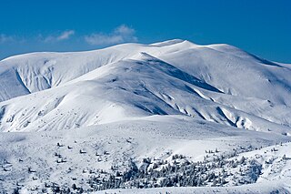
The Balkans, corresponding partially with the Balkan Peninsula, is a geographical area in southeastern Europe with various geographical and historical definitions. The region takes its name from the Balkan Mountains that stretch throughout the whole of Bulgaria. The Balkan Peninsula is bordered by the Adriatic Sea in the northwest, the Ionian Sea in the southwest, the Aegean Sea in the south, the Turkish straits in the east, and the Black Sea in the northeast. The northern border of the peninsula is variously defined. The highest point of the Balkans is Musala, 2,925 metres (9,596 ft), in the Rila mountain range, Bulgaria.
Tylis or Tyle was a capital of a short-lived Balkan state mentioned by Polybius that was founded by Celts led by Comontorius in the 3rd century BC. Following their invasion of Thrace and Greece in 279 BC, the Gauls were defeated by the Macedonian king Antigonus II Gonatas in the Battle of Lysimachia in 277 BC, after which they turned inland to Thrace and founded their kingdom at Tylis. It was located near the eastern edge of the Haemus (Balkan) Mountains in what is now eastern Bulgaria. Some bands of Celts, namely the Tectosages, Tolistobogii and Trocmi, did not settle in Thrace, but crossed into Asia Minor to become known as the Galatians. The last king of Tylis was Cavarus who maintained good relations with the city of Byzantium. His capital was destroyed by the Thracians in 212 BC and this was also the end of his kingdom. The modern Bulgarian village of Tulovo in Stara Zagora Province now occupies the site.

The Strumica or Strumeshnitsa is a river in North Macedonia and Bulgaria. It runs through the town of Strumica and flows into the river Struma.

Belasica, Belles or Kerkini, is a mountain range in the region of Macedonia in Southeastern Europe, shared by northeastern Greece, southeastern North Macedonia (35%) and southwestern Bulgaria (20%).
Osogovo, or Osogovska Planina or Osogovski Planini, is a mountain range and ski resort between the south-western part of Bulgaria and the north-eastern part of North Macedonia. Osogovo Monastery is situated on the mountain.

Kajmakčalan (Kaimakchalan), Kaimaki, Kaimaktsalan or Voras, is a mountain on the border between Greece and North Macedonia. It is the southernmost and highest peak, 2,521 metres (8,271 ft), of a range known in Greek as the Voras Mountains and in Macedonian as Nidže. In terms of prominence, the Kaimaktsalan summit rises 1,758 metres above its surroundings. The frontier between the two countries runs across the summit. It is the third-highest peak in Greece after Mytikas and Smolikas and the fifth-highest in North Macedonia.

Tresonče is a mountainous village located in the Mavrovo and Rostuša Municipality in western North Macedonia. It is a mountain village populated by Macedonian Orthodox Christians. There are also several Orthodox churches in the village.
Gyueshevo is a village in Kyustendil Municipality, Kyustendil Province, in western Bulgaria. As of 2006 the population is 275 and the mayor is Stoyne Maksimov. The village is located on the border with North Macedonia and is the most important of the three border checkpoints between the two countries. It is the last stop of the railway from Sofia. This railway is intended to link the capital to Skopje, but the Macedonian section of the line has not been built. Gyueshevo lies at 42°14′13″N22°28′35″E, 1,016 metres above sea level, in the Osogovo mountains. The local railway station was built in 1910, while the first school dates to 1888. The Prosveta community centre (chitalishte) was opened in 1921. There is also a church mausoleum dedicated to the perished Bulgarian soldiers in the Balkan Wars and the First World War. Gyueshevo was first mentioned in 1570 as Gyuveshevo. The name is thought to originate from the personal name Gyuesh, probably a derivative of George; –esh is a rare personal name suffix used in names such as Dobresh, Malesh or Radesh.

Klyuch is a village in south-westernmost Bulgaria, part of Petrich Municipality, Blagoevgrad Province. It lies 455 metres above sea level. As of 2005, it has a population of 1,113 and the mayor is Hristo Markov.

Kozjak is a mountain situated on the border between North Macedonia and Serbia. It is situated north-east from Kumanovo. The tallest peak of Kozjak is Virovi at 1284 meters. The region is also known as Kozjačija (Козјачија). The river Pčinja flows along the western edge of the mountain.

Džepčište is a village in the municipality of Tetovo, North Macedonia.
North Macedonia, officially the Republic of North Macedonia, is a landlocked country in Southeast Europe. It shares land borders with Greece to the south, Albania to the west, Bulgaria to the east, Kosovo to the northwest and Serbia to the north. It constitutes approximately the northern third of the larger geographical region of Macedonia. Skopje, the capital and largest city, is home to a quarter of the country's population of 1.83 million. The majority of the residents are ethnic Macedonians, a South Slavic people. Albanians form a significant minority at around 25%, followed by Turks, Roma, Serbs, Bosniaks, Aromanians and a few other minorities.

Doleni is a village in the municipality of Sandanski, in Blagoevgrad Province, south-western Bulgaria and as of 2013 has only 3 inhabitants. It is situated at the south-western foothills of the Pirin mountains a few kilometres north of the Melnik Earth Pyramids. Further north is located Pirin National Park, a UNESCO World Heritage Site. Doleni lies some 124 km south of the national capital Sofia.

Vrutok is a village in the municipality of Gostivar, North Macedonia. The village is situated on the slopes of Mount Bistra by the Korab mountains, near the town of Gostivar.

The Battle of Lerin or Battle of Florina or Chegan offensive was an offensive operation of the Bulgarian army fought between 17–28 August 1916, during the First World War, in which they conquered the city of Florina but failed to take Chegan.
Lisolaj is a village in the Bitola Municipality of North Macedonia. It used to be part of the former municipality of Kukurečani.

National Road I-6 is a major road in Southern Bulgaria. It runs from Gyueshevo at the border with North Macedonia and Burgas on the Black Sea coast. With a total length of 508.5 km (316.0 mi), I-6 road is the longest road in Bulgaria.

Podgorci is a small village in the municipality of Struga, North Macedonia.

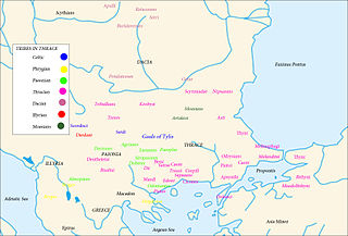
Pirin Macedonia or Bulgarian Macedonia is the third-biggest part of the geographical region of Macedonia, today in southwestern Bulgaria. This region coincides with the borders of the Blagoevgrad Province, as well as the surrounding area of Barakovo from the Kyustendil Province. After World War I, Strumica and the surrounding area were broken away from the region and were ceded to Yugoslavia.

