- The Dnieper River passes through many cities — notably Kyiv, the capital of Ukraine. In Kyiv, more than seven bridges cross the river.
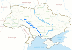
- A map of the Southern Buh flowing through Ukraine (in Lithuanian).
- Kalmius river, Donetsk
Ukraine has around 23,000 rivers, with most of the rivers draining into the Black Sea and Azov Sea and belonging to the larger Mediterranean basin. Those rivers mostly flow in a southerly direction, except for the Pripyat tributaries in Volhynia and Dniester tributaries in Prykarpattia. A few western Ukraine rivers drain to the north west through Poland to the Baltic Sea, as part of the Western Bug drainage basin. The most notable rivers of Ukraine include the Dnieper, Dniester, Southern Buh, and Siverskyi Donets. The longest river is the Dnieper, the longest tributary is the Dnieper's tributary Desna. Two of the Danube's tributaries in Ukraine, the Prut and the Tysa, are longer than the main river within Ukraine.
The territory of Ukraine can be divided into nine hydrographic zones according to major river basins, including the basins of the Wisła (Western Bug and San), Danube, Dniester, Southern Bug, Dnieper, Don, the rivers of the Black Sea littoral, the Sea of Azov littoral, and separately the rivers of Crimea. The biggest river basin by area is the Dnieper which is subdivided into the Pripyat basin, Desna basin, basin of Middle Dnieper, basin of Lower Dnieper. Beside Dnieper, basin of the Danube zoning is also subdivided into basin of Tysa, basin of Prut and Siret, and basin of the Lower Danube.
Listed are rivers over 150 km (93 mi) long. Length is in kilometers.
Name | Name (Cyrillic) | Length (in Ukraine, including borders) | Length (total) | Drainage area | Basin |
---|---|---|---|---|---|
Dnieper | Дніпро | 981 | 2201 | 291,400 | Dnieper-Bug Estuary |
Southern Bug | Південний Буг | 806 | 806 | 63,700 | Dnieper-Bug Estuary |
Dniester | Дністер | 705 | 1362 | 72,100 | Black Sea |
Siverskyi Donets | Сіверський Донець | 672 | 1053 | 98,900 | Don |
Desna | Десна | 591 | 1130 | 88,900 | Dnieper |
Horyn | Горинь | 577 [1] | 659 [1] | 27,010 [1] | Pripyat |
Inhulets | Інгулець | 549 | 549 | 14,870 | Dnieper |
Psel | Псел | 526 | 717 | 22,800 | Dnieper |
Sluch | Случ | 451 | 451 | 13,800 | Horyn |
Styr | Стир | 445 | 494 | 13,100 | Pripyat |
Western Bug | Західний Буг | 401 | 831 | 73,500 | Narew [Narva] |
Teteriv | Тетерів | 385 | 385 | 15,300 | Dnieper |
Sula | Сула | 365 | 365 | 19,600 | Dnieper |
Inhul | Інгул | 354 | 354 | 9,890 | Southern Bug |
Vorskla | Ворскла | 348 | 464 | 14,700 | Dnieper |
Ros | Рось | 346 | 346 | 12,600 | Dnieper |
Oril | Оріль | 346 [2] | 346 [2] | 9,800 [2] | Dnieper |
Udai | Удай | 327 [2] | 327 [2] | 7,030 [2] | Sula |
Vovcha | Вовча | 323 [2] | 323 [2] | 13,300 [2] | Samara |
Samara | Самара | 320 | 320 | 22,600 | Dnieper |
Khorol | Хорол | 308 [2] | 308 [2] | 3,870 [2] | Psel |
Prut | Прут | 272 | 967 | 27,500 | Danube |
Pripyat | Прип'ять | 261 | 761 | 121,000 | Dnieper |
Uzh | Уж | 256 [2] | 256 [2] | 8,080 [2] | Pripyat |
Zbruch | Збруч | 244 | 244 | 3,400 | Dniester |
Seret | Серет | 242 | 242 | 3,900 [3] | Dniester |
Stryi | Стрий | 232 | 232 | 3,060 [4] | Dniester |
Seim | Сейм | 222 [5] | 748 [5] | 27,500 | Desna |
Aidar | Айдар | 213 [6] | 264 [6] | 7,420 | Siverskyi Donets |
Kalmius | Кальміус | 209 [2] | 209 [2] | 5,070 [2] | Sea of Azov |
Salhir | Салгир | 204 [7] | 204 [7] | 3,750 [7] | Syvash |
Tysa | Тиса | 201 | 966 | 11,300 [2] | Danube |
Vysun | Висунь | 201 [2] | 201 [2] | 2,670 [2] | Inhulets |
Oster | Остер | 199 [2] | 201 [2] | 2,950 [2] | Desna |
Luhan | Лугань | 198 [2] | 198 [2] | 3,740 [2] | Siverskyi Donets |
Molochna | Молочна | 197 [2] | 197 [2] | 3,450 [2] | Sea of Azov |
Snov | Снов | 190 [2] | 253 [2] | Desna | |
Stokhid | Стохід | 188 [2] | 188 [2] | 3,150 [2] | Pripyat |
Turija | Турія | 184 [2] | 184 [2] | 2,800 [2] | Pripyat |
Oskil | Оскiл | 177 [2] | 472 [2] | Siverskyi Donets | |
Danube | Дунай | 174 [2] | 2900 [2] | Black Sea | |
Ubort | Уборть | 171 [2] | 292 [2] | Pripyat | |
Krynka | Кринка | 170 [2] | 180 [2] | Mius River | |
Smotrych | Смотрич | 168 [2] | 168 [2] | 1,800 [2] | Dniester |
Hirsky Tikych | Гірський Тікич | 167 [2] | 167 [2] | 3,510 [2] | Hnylyi Tikych |
Velyka Vys | Велика Вись | 166 [2] | 166 [2] | 2,860 [2] | Synyukha |
Murafa | Мурафа | 163 [2] | 163 [2] | 2,410 [2] | Dniester |
Irpin | Ірпінь | 162 [2] | 162 [2] | 3,340 [2] | Dnieper |
Tiasmyn | Тясмин | 160 [2] | 160 [2] | 4,540 [2] | Dnieper |
Bazavluk | Базавлук | 157 [2] | 157 [2] | 4,200 [2] | Dnieper |
Hnylyi Tikych | Гнилий Тікич | 157 [2] | 157 [2] | 3,150 [2] | Synyukha |
Ikva | Іква | 156 [2] | 156 [2] | 2,250 [2] | Styr |
Chychyklia | Чичиклія | 156 [2] | 156 [2] | 2,120 [2] | Southern Bug |
Tylihul | Тилігул | 154 [2] | 154 [2] | 3,300 [2] | Black Sea |
Derkul | Деркул | 153 [2] | 163 [2] | Siverskyi Donets | |
Stvyha | Ствига | 66 [2] | 178 [2] | 5,440 [2] | Pripyat |
Velykyi Kuialnyk | Великий Куяльник | 150 [2] | 150 [2] | 1,860 [2] | Black Sea |
The most water in Ukraine is carried by Dnieper. Its annual drainage volume is 52.42 km3 (12.58 cu mi). The only other river that has higher drainage volume is the Danube which running through Central Europe within Ukraine stretches only for 174 km (108 mi). The average annual drainage of the Danube is around 123 km3 (30 cu mi).
The deepest river of Ukraine is Dniester. In its mid stream between Pyzhniv village and Mohyliv-Podilsky through the Dniester canyon (Podillia Upland) the river narrows to 1.5 km (0.93 mi) in width and deepens up to 10 m (33 ft).
The biggest water amount among distributaries is carried by the Chilia branch.
The biggest river delta in Ukraine belongs to Dnieper and has area of 350 km2 (140 sq mi), while the Danube Delta within Ukraine is only 120 km2 (46 sq mi).
Ukraine is the second-largest European country, after Russia. Its various regions have diverse geographic features ranging from highlands to lowlands, as well as climatic range and a wide variety in hydrography. Most of the country lies within the East European Plain.
Transport in Ukraine includes ground transportation, water, air transportation, and pipelines. The transportation sector accounts for roughly 11% of the country's gross domestic product and 7% of total employment.
Polesia, also called Polissia, Polesie, or Polesye, is a natural (geographic) and historical region in Eastern Europe within the bigger East European Plain, including part of eastern Poland and the Belarus–Ukraine border region. This region should not be confused with parts of Russia also traditionally called "Polesie".
The Dnieper, also called Dnepr or Dnipro, is one of the major transboundary rivers of Europe, rising in the Valdai Hills near Smolensk, Russia, before flowing through Belarus and Ukraine to the Black Sea. Approximately 2,200 km (1,400 mi) long, with a drainage basin of 504,000 square kilometres (195,000 sq mi), it is the longest river of Ukraine and Belarus and the fourth-longest river in Europe, after the Volga, Danube, and Ural rivers.
The Pripyat or Prypiat is a river in Eastern Europe. The river, which is approximately 761 km (473 mi) long, flows east through Ukraine, Belarus, and Ukraine again, draining into the Dnieper.
The Seversky Donets or Siverskyi Donets, usually simply called the Donets, is a river on the south of the East European Plain. It originates in the Central Russian Upland, north of Belgorod, flows south-east through Ukraine and then again through Russia to join the river Don, about 100 km (62 mi) from the Sea of Azov. The Donets is the fourth-longest river in Ukraine, and the largest in eastern Ukraine, where it is an important source of fresh water. It gives its name to the Donets Basin, known commonly as the Donbas, an important coal-mining and industrial region in Ukraine.
The Bug or Western Bug is a major river in Central Europe that flows through Belarus (border), Poland, and Ukraine, with a total length of 774 kilometres (481 mi). A tributary of the Narew, the Bug forms part of the border between Belarus and Poland for 178 kilometres (111 mi) and part of the border between Ukraine and Poland for 185 kilometres (115 mi).
The Desna is a river in Russia and Ukraine, a major left-tributary of the Dnieper. Its name means "right hand" in the Old East Slavic language. It has a length of 1,130 km (702 mi), and its drainage basin covers 88,900 km2 (34,324 sq mi).
The East European Plain is a vast interior plain extending east of the North European Plain, and comprising several plateaus stretching roughly from 25 degrees longitude eastward. It includes Volhynian-Podolian Upland on its westernmost fringe, the Central Russian Upland, and, on the eastern border, encompasses the Volga Upland. The plain includes also a series of major river basins such as the Dnepr Basin, the Oka–Don Lowland, and the Volga Basin. At the southeastern point of the East European Plain are the Caucasus and Crimean mountain ranges. Together with the North European Plain, and covering the Baltic states, European Russia, Belarus, Ukraine, Moldova, southeastern Romania, and, at its southernmost point, the Danubian Plain in Northern Bulgaria, it constitutes the majority of the Great European Plain, the greatest mountain-free part of the European landscape. The plain spans approximately 4,000,000 km2 (2,000,000 sq mi) and averages about 170 m (560 ft) in elevation. The highest point of the plain, located in the Valdai Hills, is 346.9 metres (1,138.1 ft).
The Bureya is a south-flowing, left tributary of the Amur river in Russia. It is 623 kilometres (387 mi) long, and has a drainage basin of 70,700 square kilometres (27,300 sq mi). Its name comes from the Evenk word birija, meaning river.
Ivankovo Reservoir or Ivankovskoye Reservoir, informally known as the Moscow Sea, is the uppermost reservoir on the Volga, in Moscow and Tver Oblasts of Russia, located some 130 km (81 mi) north of Moscow. The dam of the reservoir is situated in the town of Dubna. The town of Konakovo is located on its southern coast. The reservoir is connected to the Moskva by the Moscow Canal, and is the principal fresh water source for the city of Moscow. Its area is 327 km2 (126 sq mi), and the area of its drainage basin is 41,000 km2 (16,000 sq mi).
The racer goby is a species of goby native to fresh, sometimes brackish, waters, of the Black Sea basin. It is a Ponto-Caspian relict species. The species is placed a monotypic genus, Babka, which was once considered a subgenus of genus Neogobius, but was then elevated to genus-status based on the molecular analysis.
Muravsky Trail or Murava Route was an important trade route and an invasion route of the Crimean Nogays during the Russo-Crimean Wars of the 16th and early 17th centuries. As described in the Book to the Great Chart of Muscovy (1627), the route went north from the Tatar fortress of Or Qapı (Perekop), the gateway of the Crimean peninsula, east of the Dnieper, to the Russian fortress of Tula, 193 km south of Moscow.
The Ubort is a river in Zhytomyr Oblast (Ukraine) and Gomel Region (Belarus), a right tributary to the Pripyat in the Dnieper river basin. It is 292 kilometres (181 mi) long, and has a drainage basin of 5,820 square kilometres (2,250 sq mi).
Canals in Ukraine are mostly for irrigation or water supply. Most of them are supervised by the Canal Administration of the State Agency of water resources of Ukraine. As the rest of water resources canals compose the Water Fund of Ukraine and are included in the Water Cadastre (register) of Ukraine.
Voronizh is a rural settlement in Shostka Raion, Sumy Oblast, Ukraine. It is located on the banks of the Osota, a left tributary of the Desna, in the drainage basin of the Dnieper. Voronizh belongs to Shostka urban hromada, one of the hromadas of Ukraine. Population: 6,560.
The Krasna is a river in Ukraine, a tributary on the left bank of the Donets River, within the Don River Basin.
The Dnieper Basin is the drainage basin of the Dnieper River, covering an area of 531,817 square kilometres (205,336 sq mi). Its water resources compose around 80% of the total for all Ukraine.
The Siverskyi Donets – Donbas Canal is a canal in Eastern Ukraine, connecting the Siverskyi Donets with the Kalmius River. The canal was built in the 1950s to improve the area's water supplies.
(Copies of the works are available at the Electronic library "Chtyvo")